
Bayside in Saint Andrews, New Brunswick — The Atlantic Provinces (North America)
Saint Croix Island International Historic Site
⎯⎯⎯
Lieu historique international de l'Île Sainte-Croix

Photographed by Cosmos Mariner, July 13, 2019
1. Saint Croix Island International Historic Site /
Lieu historique international de l'Île Sainte-Croix Marker
Lieu historique international de l'Île Sainte-Croix Marker

Welcome
On Saint Croix Island in 1604, French nobleman-courtier Pierre Dugua Sieur de Monts established a settlement. This outpost was the first attempt by the French at year-round colonization in the territory they called La Cadie or l’Acadie.
The experience of the French on Saint Croix Island taught them much about adapting to the environment and interacting with the Aboriginal peoples. These insights formed the foundation for an enduring French presence in northeastern North America.
Enjoy your visit.
Bienvenue
En 1604, Pierre Dugua, sieur de Monts, gentilhomme et courtisan français, établit un avant-poste dans l'île Sainte-Croix. Cet établissement est la première tentative de colonisation permanente jamais réalisée par les Français sur le territoire qu'ils appellent La Cadie ou l'Acadie.
Les expériences des Français dans l'île Sainte-Croix leur font acquérir les connaissances nécessaires pour s'adapter au milieu et nouer des liens avec les peuples autochtones. Ces connaissances posent les bases de l'établissement d'une présence française durable dans le nord-est de l'Amérique du Nord.
Nous vous souhaitons une agréable visite.
Erected by Parks
this page online
Topics and series. This historical marker is listed in these topic lists: Colonial Era • Settlements & Settlers. In addition, it is included in the Acadian History series list. A significant historical year for this entry is 1604.
Location. 45° 8.077′ N, 67° 6.739′ W. Marker is in Bayside, New Brunswick, in Saint Andrews. It can be reached from New Brunswick Highway 127 (New Brunswick Route 127) 9 kilometers south of Route 1, on the right when traveling south. Marker is located at the Saint Croix Island National Historic Site, at the beginning of the interpretive trail. Touch for map. Marker is at or near this postal address: 3509 New Brunswick Highway 127, Bayside NB E5B 2V2, Canada. Touch for directions.

Regionally, this marker is in Charlotte County and the Fundy Isles. It is also in the Maritimes and in Atlantic Canada. Globally, it is in the North Atlantic Region, North America, the Western Hemisphere, the Western World, and the Anglosphere. Historically, it finds itself in what was once a British colony, the Viceroyalty of New France, and Acadia.
Other nearby markers. At least 8 other
Photographed by Cosmos Mariner, July 13, 2019
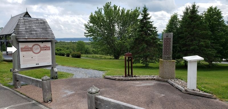
2. Saint Croix Island International Historic Site Marker
(wide view)
(wide view)
Related markers. Click here for a list of markers that are related to this marker. Saint Croix Island International Historic Site / Île Sainte-Croix Lieu historique international
Also see . . .
1. Saint Croix Island International Historic Site: Pierre Dugua, Sieur de Mons. He was named Lieutenant General for the "New World". Henri IV granted him this title on 8 November 1603 and gave him the monopoly on the land located between the 40th and 46th parallels. Having sold his belongings to finance his enterprise, he agreed to "conquer" this land in the name of King Henri IV and to establish permanent French settlements. (Submitted on January 16, 2020, by Cosmos Mariner of Cape Canaveral, Florida.)
2. Pierre Dugua De Monts. He was given a trading monopoly and appointed lieutenant-general “of the coasts, lands and confines of Acadia, Canada and other places in New France,” there to establish 60 colonists a year and to win the Indians to the Christian faith. Exploring the coast in June 1604, de Monts and his companions came to an island all felt suitable for their first settlement. Île Sainte-Croix (Dochet Island), as it came to be called, was chosen for its central position, its good anchorage, its ease of defence against attack, and because little time remained to prepare for the winter season. (Submitted on January 16, 2020, by Cosmos Mariner of Cape Canaveral, Florida.)
Credits. This page was last revised on January 19, 2020. It was originally submitted on January 15, 2020, by Cosmos Mariner of Cape Canaveral, Florida. This page has been viewed 421 times since then and 29 times this year. Photos: 1. submitted on January 15, 2020, by Cosmos Mariner of Cape Canaveral, Florida. 2. submitted on January 16, 2020, by Cosmos Mariner of Cape Canaveral, Florida.
