Near Sirmans in Clinch County, Georgia — The American South (South Atlantic)
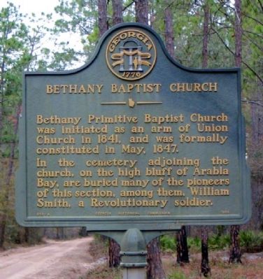
Bethany Baptist Church
In the cemetery adjoining the church, on the high bluff of Arabia Bay, are buried many of the pioneers of this section, among them, William Smith, a Revolutionary soldier.
Erected 1958 by Georgia Historical Commission. (Marker Number 032-4.)
Topics and series. This historical marker is listed in these topic lists: Cemeteries & Burial Sites • Churches & Religion • War, US Revolutionary. In addition, it is included in the Georgia Historical Society series list. A significant historical month for this entry is May 1847.
Location. 31° 6.642′ N, 82° 53.19′ W. Marker is near Sirmans, Georgia, in Clinch County. Marker is on Arabia Church Road, 0.1 miles north of Georgia Route 122, on the right when traveling north. Touch for map. Marker is in this post office area: Lakeland GA 31635, United States of America. Touch for directions.
Other nearby markers. At least 8 other markers are within 10 miles of this marker, measured as the crow flies. First Court in Clinch County (approx. 5.3 miles away); Guest Mill Pond (approx. 5˝ miles away); a different marker also named Guest Mill Pond (approx. 5˝ miles away); Salem Church (approx. 6.1 miles away); Kinnaird Trail (approx. 6˝ miles away); Clinch County World War II Memorial (approx. 9.7 miles away); Clinch Court House (approx. 9.7 miles away); Fender Cemetery (approx. 9.8 miles away).
Credits. This page was last revised on January 26, 2020. It was originally submitted on December 24, 2008, by David Seibert of Sandy Springs, Georgia. This page has been viewed 1,488 times since then and 18 times this year. Photo 1. submitted on December 24, 2008, by David Seibert of Sandy Springs, Georgia. • Bill Pfingsten was the editor who published this page.
Editor’s want-list for this marker. A wide shot of the marker and its surroundings. • Can you help?
