Lower Merion Township near Bala Cynwyd in Montgomery County, Pennsylvania — The American Northeast (Mid-Atlantic)
Switchback Bridge
Cynwyd Heritage Trail
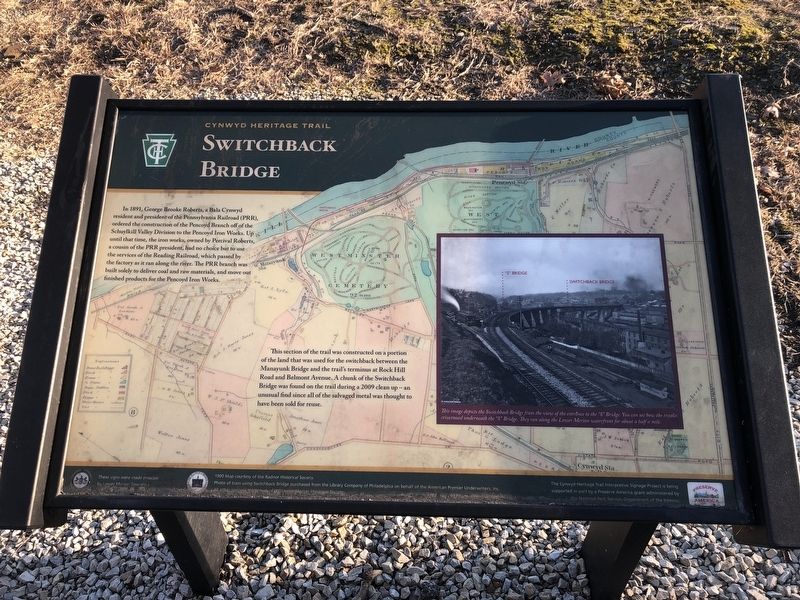
In 1891, George Brooke Roberts, a Bala Cynwyd resident and president of the Pennsylvania Railroad (PRR), ordered the construction of the Pencoyd Bridge off the Schuylkill Valley Division to the Pencoyd Iron Works. Up until that time, the iron works, owned the Percival Roberts, a cousin of the PRR president, had no choice but to use the services of the Reading Railroad, which passed by the factory as it ran along the river. The PRR branch was built solely to deliver coal and raw materials, and move out finished products for the Pencoyd Iron Works.
This section of the trail was constructed on a portion of the land that was used for the switchback between the Manayunk Bridge and the trail's terminus at Rock Hill Road and Belmont Avenue. A chunk of the Switchback Bridge was found on the trail during a 2009 clean up — an unusual find since all of the salvaged metal was thought to have been sold for reuse.
Erected by Lower Merion Township; Preserve America grant administered by the National Park Service, U.S. Department of the Interior.
Topics and series. This historical marker is listed in these topic lists:
this page online
Location. 40° 1.465′ N, 75° 13.74′ W. Marker is near Bala Cynwyd, Pennsylvania, in Montgomery County. It is in Lower Merion Township. It is on Cynwyd Heritage Trail 0.2 miles west of Manayunk Bridge Trail, on the right when traveling west. Touch for map. Marker is at or near this postal address: 100 Belmont Ave, Bala Cynwyd PA 19004, United States of America. Touch for directions.

Regionally, this marker is in Southeast Pennsylvania and in Greater Philadelphia. It is also in the American Northeast and in the Mid-Atlantic. Globally, it is in North America, the Western Hemisphere, the Western World, and the Anglosphere. Historically, it finds itself in what was once the Haudenosaunee (Iroquois) Confederacy and also one of the original Thirteen Colonies.
Other nearby markers. At least 8 other markers are within walking distance of this marker: Pencoyd Iron Works (here, next to this marker); Sebastian A. Rudolph's Ashland Paper Mill
Credits. This page was last revised on February 7, 2023. It was originally submitted on March 14, 2020, by Devry Becker Jones of Washington, District of Columbia. This page has been viewed 664 times since then and 44 times this year. Photos: 1, 2. submitted on March 14, 2020, by Devry Becker Jones of Washington, District of Columbia.
