Near Smithfield in Johnston County, North Carolina — The American South (South Atlantic)
Federal Line of March
“Poor North Carolina …”
— Carolinas Campaign —
(Preface): The Carolinas Campaign began on February 1, 1865, when Union Gen. William T. Sherman led his army north from Savannah, Georgia, after the “March to the Sea.” Sherman's objective was to join Gen. Ulysses S. Grant in Virginia to crush Gen. Robert E. Lee's Army of Northern Virginia. Scattered Confederate forces consolidated in North Carolina, the Confederacy's logistical lifeline, where Sherman defeated Gen. Joseph E. Johnston's last-ditch attack at Bentonville. After Sherman was reinforced at Goldsboro late in March, Johnston saw the futility of further resistance and surrendered on April 26, essentially ending the Civil War.
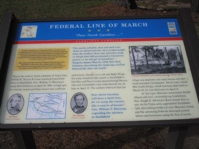
“The marks of bullet, shot and shell were thick on shrub and tree. At a certain height from the surface, there was scarcely a twig or bough that did not present a transverse groove, or its abrupt termination.” - Surgeon James Mowris, 117th New York Infantry, describing the landscape around Bentonville after the battle.
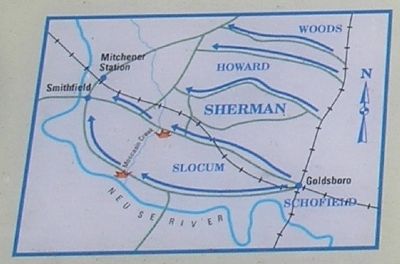
This is the road on which elements of Union Gen. Alfred H. Terry’s X Corps marched from Goldsboro to Smithfield. Gen. William T. Sherman’s army left Goldsboro on April 10, 1865, in high spirits, having rested and been issued new uniforms and rations. Divided into Left and Right Wings, the army completed the march to Smithfield in two days, and Terry’s corps passed through Bentonville and bivouacked a few miles beyond the village on April 11. The soldiers observed that the village was destitute and many houses still sheltered wounded Confederates. Terry’s men rebuilt Mill Creek Bridge, which had been destroyed on March 22, by mid-afternoon on April 11.
At this time, Sherman commanded 88,948 officers and men, outnumbering Confederate Gen. Joseph E. Johnston’s army almost four to one. As the Union army approached Smithfield, light skirmishing broke out near Moccasin Creek, and the advancing Federals destroyed several homes and businesses along the line of march.
“Poor North Carolina will have a hard time, for we sweep the country like a swarm of locusts.” Gen. William T. Sherman, regarding the advance to Smithfield.
Erected by North Carolina Civil War Trails.
Topics and series. This historical marker
is listed in this topic list: War, US Civil. In addition, it is included in the North Carolina Civil War Trails series list. A significant historical date for this entry is March 19, 1865.
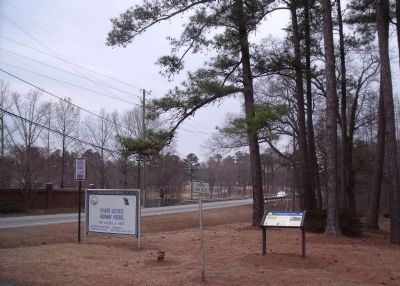
Location. 35° 28.098′ N, 78° 23.092′ W. Marker is near Smithfield, North Carolina, in Johnston County. Marker is on U.S. 301 north of Carroll Drive, on the right when traveling north. Located near the office of NC Highway Patrol Troop C, District VI. Touch for map. Marker is at or near this postal address: 3783 US Hwy 301 S, Four Oaks NC 27524, United States of America. Touch for directions.
Other nearby markers. At least 8 other markers are within 4 miles of this marker, measured as the crow flies. Sherman’s March (approx. 2.9 miles away); Hastings House (approx. 3.6 miles away); Town of Smithfield (approx. 3.6 miles away); a different marker also named The Town of Smithfield (approx. 3.6 miles away); Edward W. Pou (approx. 3.7 miles away); Occupation of Smithfield (approx. 3.7 miles away); Sherman Receives News of Lee's Surrender in Smithfield (approx. 3.7 miles away); Ava Gardner (approx. 3.7 miles away). Touch for a list and map of all markers in Smithfield.
More about this marker. The upper right of the marker contains an illustration from Harper’s Weekly of “Sherman’s destruction on the Southern landscape.” The bottom of the marker features photographs of Generals Alfred H. Terry and William T. Sherman, courtesy of the Library of Congress. Also present is a map of Union troop movements from Goldsboro to Smithfield.
Credits. This page was last revised on May 9, 2023. It was originally submitted on December 26, 2008, by Bill Coughlin of Woodland Park, New Jersey. This page has been viewed 2,246 times since then and 26 times this year. Last updated on May 9, 2023, by Michael Buckner of Durham, North Carolina. Photos: 1, 2. submitted on December 26, 2008, by Bill Coughlin of Woodland Park, New Jersey. 3. submitted on March 12, 2010, by Bernard Fisher of Richmond, Virginia. • J. Makali Bruton was the editor who published this page.


