Richmond in Chesterfield County, Virginia — The American South (Mid-Atlantic)
Fort Stevens
Butler’s Campaign Ends
— Bermuda Hundred Campaign —
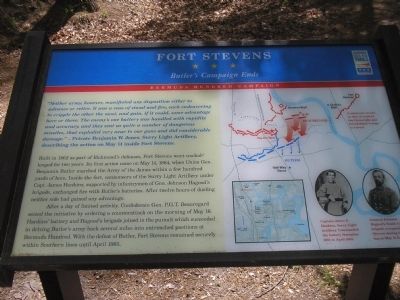
“Neither army, however, manifested any disposition either to advance or retire. It was a case of stand and fire, each endeavoring to cripple the other the most, and gain, if it could, some advantage here or there. The enemy’s one battery was handled with rapidity and accuracy, and they sent us quite a number of dangerous missiles, that exploded very near to our guns and did considerable damage.” - Private Benjamin W. Jones, Surry Light Artillery, describing the action on May 14 inside Fort Stevens.
Built in 1862 as part of Richmond’s defenses, Fort Stevens went unchallenged for two years. Its first action came on May 14, 1864, when Union Gen. Benjamin Butler marched the Army of the James within a few hundred yards of here. Inside the fort, cannoneers of the Surry Light Artillery under Capt. James Hankins, supported by infantrymen of Gen. Johnson Hagood’s brigade, exchanged fire with Butler’s batteries. After twelve hours of dueling neither side had gained any advantage.
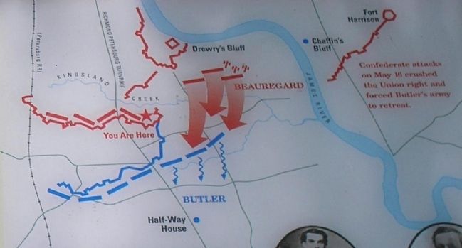
After a day of limited activity, Confederate Gen. P.G.T. Beauregard seized the initiative by ordering a counterattack on the morning of May 16. Hankins’ battery and Hagood’s brigade joined in the pursuit which succeeded in driving Butler’s army back several miles into entrenched positions at Bermuda Hundred. With the defeat of Butler, Fort Stevens remained securely within Southern lines until April 1865.
Erected by Virginia Civil War Trails.
Topics and series. This historical marker is listed in these topic lists: Forts and Castles • War, US Civil. In addition, it is included in the Virginia Civil War Trails series list. A significant historical year for this entry is 1862.
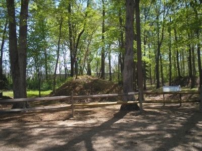
Location. 37° 24.225′ N, 77° 25.759′ W. Marker is in Richmond, Virginia, in Chesterfield County. Marker is at the intersection of Pams Avenue and Norcliff Avenue, on the left when traveling north on Pams Avenue. Marker is in Fort Stevens Historical Park, located at the corner of Pams and Norcliff Avenues. Touch for map. Marker is in this post office area: Richmond VA 23237, United States of America. Touch for directions.
Other nearby markers. At least 8 other markers are within walking distance of this marker. The Bermuda Campaign (a few steps from this marker); First Virginia Infantry Regiment (within shouting distance of this marker); a different marker also named Fort Stevens (within shouting distance of this marker); Battle of Drewry’s Bluff (approx. ¼ mile away); Drewry’s Bluff Defences (approx. 0.3 miles away); Drewry’s Bluff Battlefield (approx. half a mile away); Second Battle of Drewry's Bluff (approx. half a mile away); Bellwood Elk Herd (approx. ¾ mile away). Touch for a list and map of all markers in Richmond.
More about this marker. Photographs of two Confederate officers appear at the bottom right of the marker. They have captions of “Captain James D. Hankins, Surry Light Artillery. Commanded the battery November 1862 to April 1865” and “General Johnson Hagood’s South Carolina brigade occupied Fort Stevens during the fighting on May 14 & 16.” The top of the marker features a battle map of the May 16 counterattack.
Also see . . . Central Virginia, Richmond and Area. CivilWarTraveler website. (Submitted on December 31, 2008, by Bill Coughlin of Woodland Park, New Jersey.)
Credits. This page was last revised on September 23, 2021. It was originally submitted on December 31, 2008, by Bill Coughlin of Woodland Park, New Jersey. This page has been viewed 1,809 times since then and 26 times this year. Photos: 1, 2, 3, 4. submitted on December 31, 2008, by Bill Coughlin of Woodland Park, New Jersey.


