Near Spotsylvania Courthouse in Spotsylvania County, Virginia — The American South (Mid-Atlantic)
Spotsylvania Court House
May 8 to 21, 1864
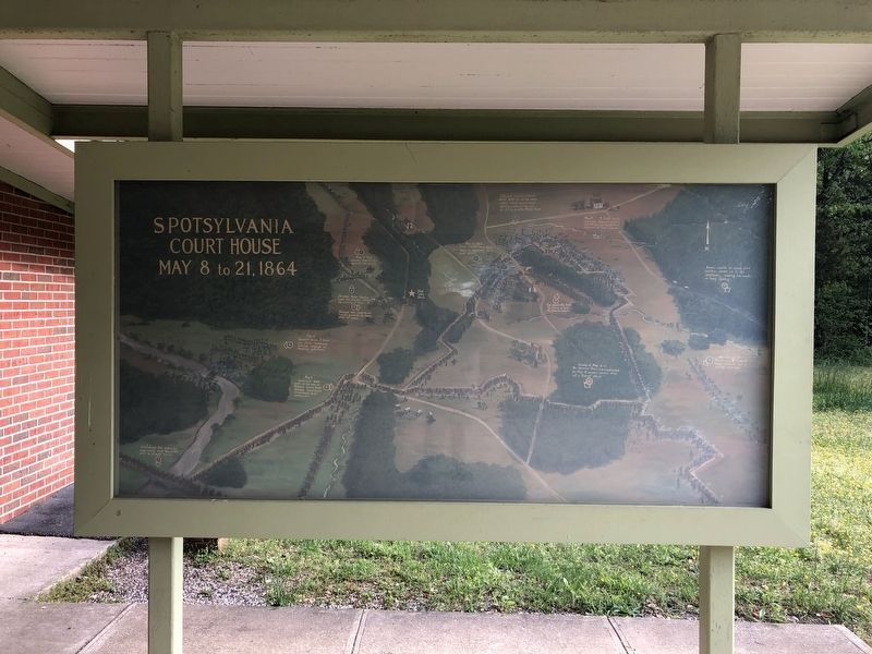
[Marker is a graphic display with captions:]
1. May 8, 1864 - Warren's Union V Corps supports the Cavalry
2. Sheridan's Union Calvary leads the advance during the evening of May 7-8
2. Fitzhugh Lee's Confederate Cavalry contests the Union move all night.
3. Confederate Gen. Anderson's Corps arrives early May 8, 1864 after an all night march.
4. May 8 - Hancock's Union II Corps and Heth's Confederate division engage in flanking operations.
4. May 8 - Anderson's men arrive on the run as Federals nearly breakthrough. Confederates immediately build earthworks.
5. May 10, 1864 - Union Colonel Emory Upton leads 12 regiments to a local success.
6. May 12. A huge early morning Federal assault overwhelms an unprepared segment of Lee's forces.
7. Lee personally leads the effort to halt the Federal attack.
8. Federal reinforcements were held up at the earthworks where hand to hand fighting raged in the rain for 20 hours at "The Bloody Angle".
9. May 12 and 18 - Burnside's IX Federal Corps attacks but is easily repulsed.
10. Evening of May 12-13 - The Harrison House line constructed. On May 18, massed
this page online
11. Grant, unable to break Lee's position, moves on to the southeast, ending two weeks of heavy fighting.
Topics. This memorial is listed in these topic lists: Forts and Castles • War, US Civil. A significant historical date for this entry is May 8, 1864.
Location. 38° 13.149′ N, 77° 36.857′ W. Memorial is near Spotsylvania Courthouse, Virginia, in Spotsylvania County. It is on Grant Drive 0.1 miles north of Brock Road (County Road 613), on the left when traveling north. Touch for map. Memorial is at or near this postal address: 9550 Grant Dr, Spotsylvania VA 22553, United States of America. Touch for directions.

Regionally, this memorial is in the Washington Metropolitan Area, in Northern Virginia, and in the Piedmont. It is also in the American South, specifically in the Upper South, in the Mid-Atlantic, and on the Eastern Seaboard. Globally, it is in the North Atlantic Region, North America, the Western Hemisphere, the Western World, and the Anglosphere. Historically, it finds itself in what was once the territory of the Mississippian Culture, one of the original Thirteen Colonies, one of the Confederate States of America, and the Antebellum South.
Other nearby markers. At least 8 other markers are within walking distance of this marker: No Turning Back (here, next to this marker); A Different Kind of War (here, next to this marker); The Battle of Spotsylvania (a few steps from this marker); Testing the Line: May 8-10 (a few steps from this marker); Grant Finds an Opening: May 12 (a few steps from this marker); The Death of Sedgwick (about 400 feet away, measured in a direct line); Laurel Hill Trail (about 400 feet away); a different marker also named The Death of Sedgwick (about 400 feet away). Touch for a list and map of all markers in Spotsylvania Courthouse.
Other markers no longer nearby. Spotsylvania Campaign (was about 400 feet away but has been permanently removed); a different marker also named Spotsylvania Campaign (was about 400 feet away but has been permanently removed).
Credits. This page was last revised on May 2, 2020. It was originally submitted on May 2, 2020, by Devry Becker Jones of Washington, District of Columbia. This page has been viewed 244 times since then and 25 times this year. Photo 1. submitted on May 2, 2020, by Devry Becker Jones of Washington, District of Columbia.
