Marker Logo HMdb.org THE HISTORICAL
MARKER DATABASE
“Bite-Size Bits of Local, National, and Global History”
Near Cumming in Forsyth County, Georgia — The American South (South Atlantic)
 

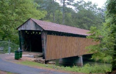
Poole's Mill Covered Bridge


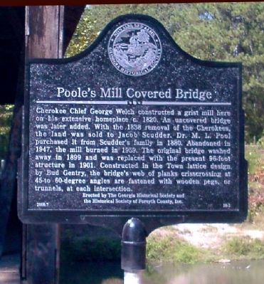
Poole's Mill Covered Bridge Marker image. Click for full size.
Photographed By David Seibert, September 16, 2000
1. Poole's Mill Covered Bridge Marker
Inscription. Cherokee Chief George Welch constructed a grist mill here on his extensive homeplace c. 1820. An uncovered bridge was later added. With the 1838 removal of the Cherokees, the land was sold to Jacob Scudder. Dr. M. L. Pool purchased it from Scudder's family in 1880. Abandoned in 1947, the mill burned in 1959. The original bridge washed away in 1899 and was replaced with the present 96-foot structure in 1901. Constructed in the Town lattice design by Bud Gentry, the bridge's web of planks crisscrossing at 45- to 60-degree angles are fastened with wood pegs, or trunnels, at each intersection.
 
Erected 2000 by The Georgia Historical Society and the Historical Society of Forsyth County, Inc. (Marker Number 58-1.)
 
Topics and series. This historical marker is listed in these topic lists: Bridges & ViaductsIndustry & CommerceNative Americans. In addition, it is included in the Covered Bridges, and the Georgia Historical Society series lists. A significant historical year for this entry is 1820.
 
Location. 34° 17.449′ N, 84° 14.557′ W. Marker is near Cumming, Georgia, in Forsyth County. Marker can be reached from Old Poole's Mill Road, 0.2 miles north of Heardsville Circle, on the right when traveling south. The marker is visible
Paid Advertisement
Click on the ad for more information.
Please report objectionable advertising to the Editor.
Click or scan to see
this page online
(with slight difficulty) from the newer concrete bridge on Poole's Mill Road, which replaced the covered bridge. Touch for map. Marker is in this post office area: Cumming GA 30028, United States of America. Touch for directions.
 
Other nearby markers. At least 8 other markers are within 9 miles of this marker, measured as the crow flies. Old Federal Road (approx. 8.2 miles away); Battle of Taliwa (approx. 8.3 miles away); Colonel William Cumming (approx. 8.3 miles away); Forsyth County (approx. 8.3 miles away); Lynching in America / Lynching in Forsyth County (approx. 8.3 miles away); Forsyth County Courthouse Cornerstone Removed (approx. 8.3 miles away); Forsyth County War Memorial (approx. 8.3 miles away); Cumming School (approx. 8.3 miles away). Touch for a list and map of all markers in Cumming.
 
More about this marker. To reach the marker and the bridge, it is necessary to park and follow an easy trail through the county park which has been constructed at the bridge.
 
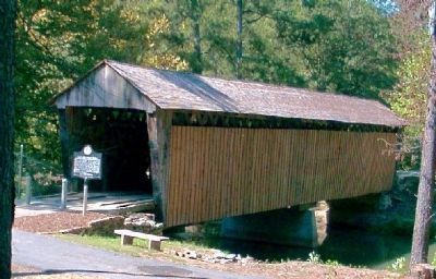
Poole's Mill Covered Bridge before the Marker was installed. image. Click for full size.
Photographed By David Seibert, June 4, 2000
2. Poole's Mill Covered Bridge before the Marker was installed.
Poole's Mill Covered Bridge and Marker image. Click for full size.
Photographed By David Seibert, September 16, 2000
3. Poole's Mill Covered Bridge and Marker
The marker and a small bench have been added (and trash cans removed).
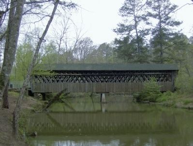
Poole's Mill Covered Bridge 2009 image. Click for full size.
Photographed By David Tibbs, April 19, 2009
4. Poole's Mill Covered Bridge 2009
The bridge was covered over with boards in the 2000 photos. This is a view taken in 2009 that shows the Town Lattice design more clearly.
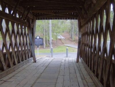
Poole's Mill Covered Bridge Interior image. Click for full size.
Photographed By David Tibbs, April 19, 2009
5. Poole's Mill Covered Bridge Interior
View looking back towards the entrance.
 
 
Credits. This page was last revised on January 26, 2021. It was originally submitted on January 2, 2009, by David Seibert of Sandy Springs, Georgia. This page has been viewed 3,343 times since then and 51 times this year. Photos:   1, 2, 3. submitted on January 2, 2009, by David Seibert of Sandy Springs, Georgia.   4, 5. submitted on May 3, 2009, by David Tibbs of Resaca, Georgia. • Kevin W. was the editor who published this page.
Share this page.  
Share on Tumblr
m=14944

CeraNet Cloud Computing sponsors the Historical Marker Database.
This website earns income from purchases you make after using our links to Amazon.com. We appreciate your support.
Paid Advertisement
Apr. 24, 2024