Fox Point in Providence in Providence County, Rhode Island — The American Northeast (New England)
Tockwotton and the Indiamen
⎯⎯⎯
Sails to Rails 1835: Providence's First Train Station
Providence Harbor Walk at Fox Point & India Point
Photographed by Devry Becker Jones (CC0), June 19, 2020
1. Tockwotton and the Indiamen side of the marker
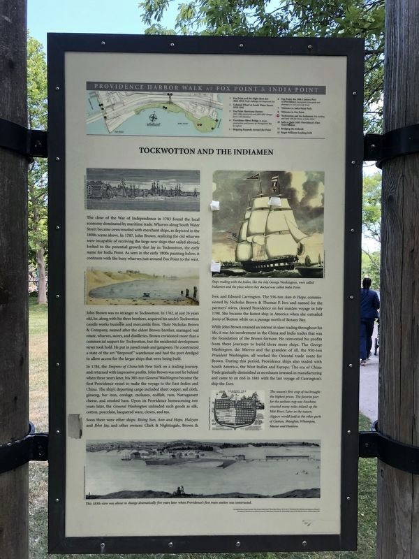
John Brown was no stranger to Tockwotton. In 1762, at just 26 years old, he, along with his three brothers, acquired his uncle's Tockwotton candle works business and mercantile firm. Their Nicholas Brown & Company, named after the eldest Brown brother, managed real estate, wharves, stores, and distilleries. Brown envisioned more than a commercial seaport for Tockwotton, but the residential development never took hold. He put in paved roads and gangways. He constructed a state of the art "fireproof" warehouse and had the port dredged to allow access for the larger ships that were
this page online
In 1784, the Empress of China left New York on a trading journey, and returned with impressive profits. John Brown was not far behind when three years later, his 385-ton General Washington became the first Providence vessel to make the voyage to the East Indies and China. The ship's departing cargo included sheet copper, sail cloth, ginseng, bar iron, cordage, molasses, codfish, rum, Narragansett cheese, and smoked ham. Upon its Providence homecoming two years later, the General Washington unloaded such goods as silk, cotton, porcelain, lacquered ware, cloves, and tea.
Soon there were other ships: Rising Sun, Ann and Hope, Halcyon and John Jay, and other owners: Clark and Nightingale, Brown & Ives, and Edward Carrington. The 536-ton Ann & Hope, commissioned by Nicholas Brown & Thomas P. Ives and named for the partners' wives, cleared Providence on her maiden voyage in July 1798. She became the fastest ship in America when she outsailed Jenny of Boston while on a passage north of Botany Bay.
While John Brown retained an interest in slave trading throughout his life, it was his involvement in the China and India
Photographed by Devry Becker Jones (CC0), June 19, 2020
2. Sails to Rails 1835: Providence's First Train Station side of the marker
The season's first crop of tea brought the highest prices. The favorite port for the earliest crop was Foochow, situated many miles inland up the Min River. Later in the season, clippers would load at the other ports of Canton, Shanghai, Whampoa, Macao and Hankow.
Photographed by Devry Becker Jones (CC0), June 19, 2020
3. Tockwotton and the Indiamen / Sails to Rails 1835: Providence's First Train Station Marker
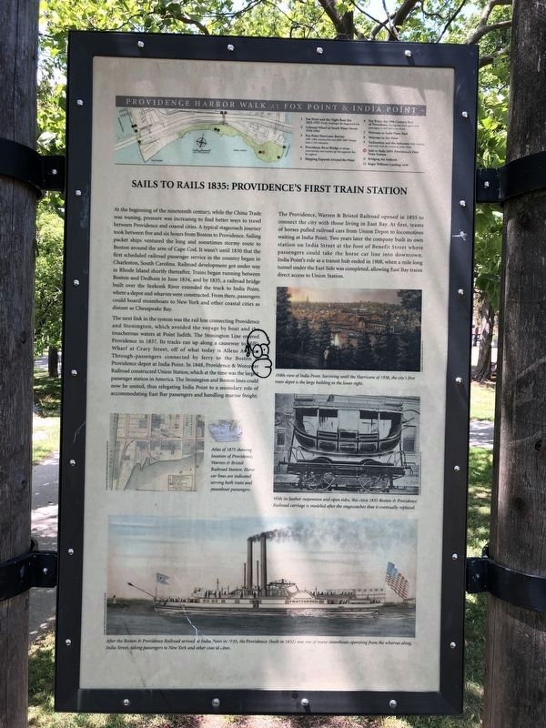
The next link in the system was the rail line connecting Providence and Stonington, which avoided the voyage by boat and the treacherous waters at Point Judith. The Stonington Line entered Providence in 1837. Its tracks ran up along a causeway to Hill's Wharf at Crary Street, off of what today is Allens Avenue. Through-passengers connected by ferry to the Boston & Providence depot at India Point. In 1848, Providence & Worcester Railroad constructed Union Station, which at the time was the largest passenger station in America. The Stonington and Boston lines could now be
Photographed by G.W.Bartlett, July 13, 2026
4. Tockwotton and the Indiamen / Sails to Rails 1835: Providence's First Train Station Marker
The Providence, Warren & Bristol Railroad opened in 1855 to connect the city with those living in East Bay. At first, teams of horses pulled railroad cars from Union Depot to locomotives waiting at India Point. Two years later the company built its own station on India Street at the foot of Benefit Street where passengers could take the horse car line into downtown. India Point's role as a transit hub ended in 1908, when a mile long tunnel under the East Side was completed, allowing East Bay trains direct access to Union Station. (Marker Number 9 & 10.)
Topics. This historical marker is listed in these topic lists: Industry & Commerce • Railroads & Streetcars • Waterways & Vessels. A significant historical month for this entry is June 1834.
Location. 41° 49.04′ N, 71° 23.44′ W. Marker is in Providence, Rhode Island, in Providence County. It is in Fox Point. It can be reached from the intersection of India Street and Tockwotton Street, on the right when traveling east. Touch for map. Marker is at or near this postal

Photographed by G.W.Bartlett, July 13, 2026
5. Loading Tea

Regionally, this marker is on Narragansett Bay. It is also in the American Northeast, in New England, and on the Eastern Seaboard. Globally, it is in the North Atlantic Region, North America, the Western Hemisphere, the Western World, and the Anglosphere. Historically, it finds itself in what was once one of the original Thirteen Colonies.
Other nearby markers. At least 8 other markers are within walking distance of this marker: Green Jacket Shoal (about 600 feet away, measured in a direct line); Bridging the Seekonk (about 700 feet away); Roger Williams Landing 1636 (about 700 feet away); Fox Point: The 19th Century Port of Providence / Shipping Expands Around the Point (approx. 0.2 miles away); Welcome to India Point Park / Welcome to Fox Point (approx. 0.2 miles away); West Bank / East Bank / Washington Bridges (approx. 0.2 miles away); History of John L. Lewis Waterfront Park (approx. 0.2 miles away); Head of Narragansett Bay / Crossing the Seekonk River (approx. 0.2 miles away). Touch for a list and map of all markers in Providence.
Additional keywords. human trafficking
Credits. This page was last revised on July 30, 2026. It was originally submitted on June 22, 2020, by Devry Becker Jones of Washington, District of Columbia. This page has been viewed 905 times since then and 54 times this year. Photos: 1, 2, 3. submitted on June 22, 2020, by Devry Becker Jones of Washington, District of Columbia. 4, 5. submitted on July 16, 2026, by G.W.Bartlett of Hingham, Massachusetts.
