Downtown Providence in Providence County, Rhode Island — The American Northeast (New England)
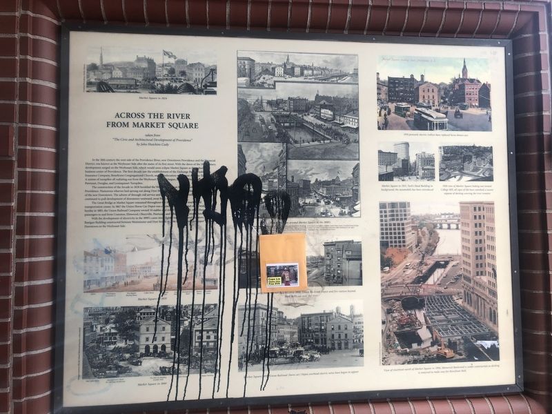
Across the River from Market Square
taken from "The Civic and Architectural Development of Providence" by John Hutchins Cady

Photographed By Devry Becker Jones (CC0), June 19, 2020
1. Across the River from Market Square Marker
In the 18th century the west side of the Providence River, now Downtown Providence and the Financial District, was known as the Weybosset Side after the name of its first street. With the dawn of the 19th century, development surged on the Weybosset Side, which would soon eclipse Market Square as the cultural and business center of Providence. The first decade saw the establishment of the Exchange Bank of Washington Insurance Company, Beneficent Congregational Church, and the relocation of most of [unreadable]. A system of turnpikes all radiating out from the Weybosset Side had begun, [unreadable] Pawtuxet, Douglas, and Louisquisset Turnpikes.
The construction of the Arcade in 1828 heralded the Weybosset Side as the [unreadable] Providence. Numerous wharves had sprung out along the Dyer Street [unreadable] of the new Downtown. The advent of through-rail service and [unreadable] continued to pull development of downtown westward, away from [unreadable].
The Great Bridge at Market Square remained throughout the 1800's [unreadable] transportation center. In 1867 the Union Horse Car Depot was erected at [unreadable] heyday in 1885, the Union Railroad Company owned 10 stables and its [unreadable] passengers to and from Cranston, Elmwood, Olneyville, Pawtuxet, and the [unreadable].
With the development of electricity in the 1890's came street light [unreadable]. Banigan Building constructed between Westminster and Dyer Streets in 1896 was the first "skyscraper" built Downtown on the Weybosset Side.
Topics. This historical marker is listed in these topic lists: Bridges & Viaducts • Industry & Commerce • Settlements & Settlers • Waterways & Vessels. A significant historical year for this entry is 1828.
Location. 41° 49.524′ N, 71° 24.547′ W. Marker has been reported damaged. Marker is in Providence, Rhode Island, in Providence County. It is in Downtown Providence. Marker is at the intersection of Westminster Street and Memorial Boulevard (U.S. 44), on the right when traveling west on Westminster Street. Touch for map. Marker is at or near this postal address: 11 Westminster St, Providence RI 02903, United States of America. Touch for directions.
Other nearby markers. At least 8 other markers are within walking distance of this location. Major Gales and Hurricanes around Market Square (here, next to this marker); Around the Corner from Market Square (within shouting distance of this marker); The History of The Weybosset Bridge (within shouting distance of this marker); The Hurricane of September 21st 1938 (within shouting distance of this marker); Luigi Scala (within shouting distance of this marker); United States Merchant Marine Memorial (about 300 feet away, measured in a direct line); PFC Alfred Silver USA (about 300 feet away); The Market House (about 300 feet away). Touch for a list and map of all markers in Providence.
Additional commentary.
1. Marker Damage
Unfortunately, as of June 19, 2020, the marker was defaced and partially unreadable.
— Submitted June 22, 2020, by Devry Becker Jones of Washington, District of Columbia.
Credits. This page was last revised on February 8, 2023. It was originally submitted on June 22, 2020, by Devry Becker Jones of Washington, District of Columbia. This page has been viewed 118 times since then and 8 times this year. Photo 1. submitted on June 22, 2020, by Devry Becker Jones of Washington, District of Columbia.
Editor’s want-list for this marker. A wide shot of the marker in context • Can you help?