College Hill in Providence in Providence County, Rhode Island — The American Northeast (New England)
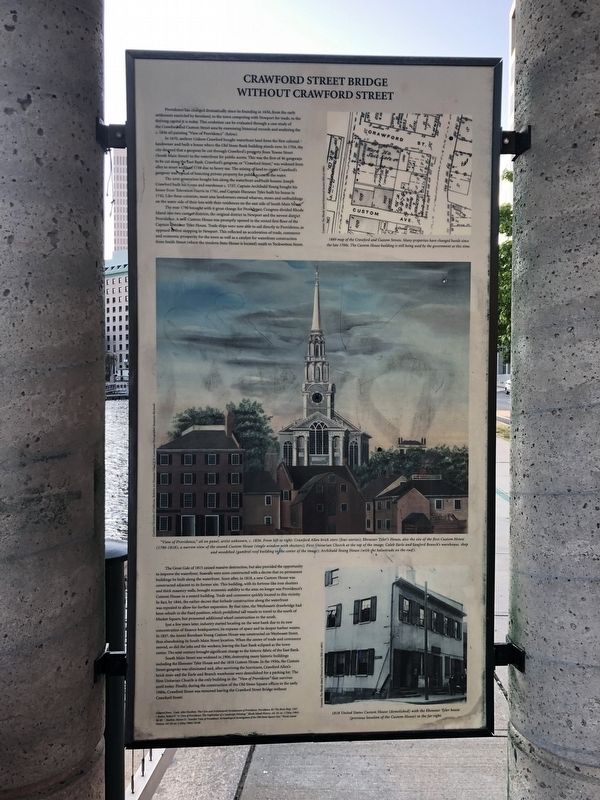
Crawford Street Bridge Without Crawford Street

Photographed By Devry Becker Jones (CC0), June 19, 2020
1. Crawford Street Bridge Without Crawford Street Marker
Providence has changed dramatically since its founding in 1636, from the early settlement enriched by farmland, to the town competing with Newport for trade, to the thriving capital it is today. This evolution can be evaluated through a case study of the Crawford Custom Street area by examining historical records and analyzing the c. 1836 oil painting "View of Providence" (below).
In 1670, seafarer Gideon Crawford bought waterfront land from the first colonial landowner and built a house where the Old Stone Bank building stands now. In 1704 , the city decreed that a gangway be cut through Crawford's property from Towne Street (South Main Street) to the waterfront for public access. This was the first of 46 gangways to be cut along the East Bank. Crawford's gangway, or "Crawford Street," was widened from alley to street width in 1738 due to heavy use. The seizing of land to create Crawford's gangway was typical of bisecting private property for public access to the water.
The next generation bought lots along the waterfront and built houses: Joseph Crawford built his house and warehouse c. 1737, Captain Archibald Young bough his house from Toleration Harris in 1741, and Captain Ebenezer Tyler built his house in 1742. Like these colonists, most area landowners owned wharves, stores and outbuildings on the water side of their lots with their residences on the east side of South Main Street.
The year 1790 brought with it great change for Providence, Congress divided Rhode Island into two custom districts, the original district in Newport and the newest district in Providence. A new Custom House was promptly opened in the rented first floor of the Captain Ebenezer Tyler House. Trade ships were now able to sail directly to Providence, as opposed to first stopping in Newport. This reflected an acceleration of trade, commerce and economic prosperity for the town as well as a catalyst for waterfront construction from Smith Street (where the modern State House is located) south to Tockwotton Street.
The Great Gale of 1815 caused massive destruction, but also provided the opportunity to improve the waterfront. Seawalls were soon constructed with a decree that no permanent buildings be built along the waterfront. Soon after, in 1818, a new Custom House was constructed adjacent to its former site. This building, with its fortress-like iron shutters and thick masonry walls, brought economic stability to the area; no longer was Providence's Custom House in a rented building. Trade and commerce quickly located to this vicinity. In fact, by 1844, the earlier decree that forbade construction along the waterfront was repealed to allow for further expansion. By that time, the Weybossett drawbridge had been rebuilt in the fixed position, which prohibited tall vessels to travel to the north of Market Square, but promoted additional wharf construction to the south.
Just a few years later, industry started locating on the west bank due to its new concentration of finance headquarters, its expanse of space and its deeper harbor waters. In 1857, the Ammi Burnham Young Custom House was constructed on Weybosset Street, thus abandoning its South Main Street location. When the center of trade and commerce moved, so did the jobs and the workers, leaving the East Bank eclipsed as the town center. The next century brought significant change to the historic fabric of the East Bank.
South Main Street was widened in 1906, destroying many historic buildings, including the Ebenezer Tyler House and the 1818 Custom House. In the 1950s, the Custom Street gangway was eliminated and, after surviving the hurricane, Crawford Allen's brick store and the Earl and Branch warehouse were demolished for a parking lot. The First Unitarian Church is the only building in the "View of Providence" that survives until today. Finally, during the construction of the Old Stone Square offices in the early 1980s, Crawford Street was removed leaving the Crawford Street Bridge without Crawford Street.
Topics and series. This historical marker is listed in these topic lists: Bridges & Viaducts • Colonial Era • Industry & Commerce • Settlements & Settlers • Waterways & Vessels. In addition, it is included in the Unitarian Universalism (UUism) series list. A significant historical year for this entry is 1636.
Location. 41° 49.389′ N, 71° 24.415′ W. Marker is in Providence, Rhode Island, in Providence County. It is in College Hill. Marker is at the intersection of South Water Street (U.S. 44) and Packet Street, on the right when traveling south on South Water Street. Touch for map. Marker is in this post office area: Providence RI 02903, United States of America. Touch for directions.
Other nearby markers. At least 8 other markers are within walking distance of this marker. Revolutions: American and Industrial (here, next to this marker); The Changing Face of the West Bank / The West Bank (within shouting distance of this marker); Easter Rising (about 300 feet away, measured in a direct line); Rhode Island Irish Famine Memorial (about 300 feet away); William Gilbane (about 300 feet away); Sons of Liberty (about 300 feet away); HMS Gaspee (about 300 feet away); The Interstate 195 Relocation Project and the Old Harbor Plan (about 400 feet away). Touch for a list and map of all markers in Providence.
Credits. This page was last revised on February 8, 2023. It was originally submitted on June 22, 2020, by Devry Becker Jones of Washington, District of Columbia. This page has been viewed 193 times since then and 30 times this year. Photo 1. submitted on June 22, 2020, by Devry Becker Jones of Washington, District of Columbia.
Editor’s want-list for this marker. A wide shot of the marker in context • Can you help?