Mackville in Washington County, Kentucky — The American South (East South Central)
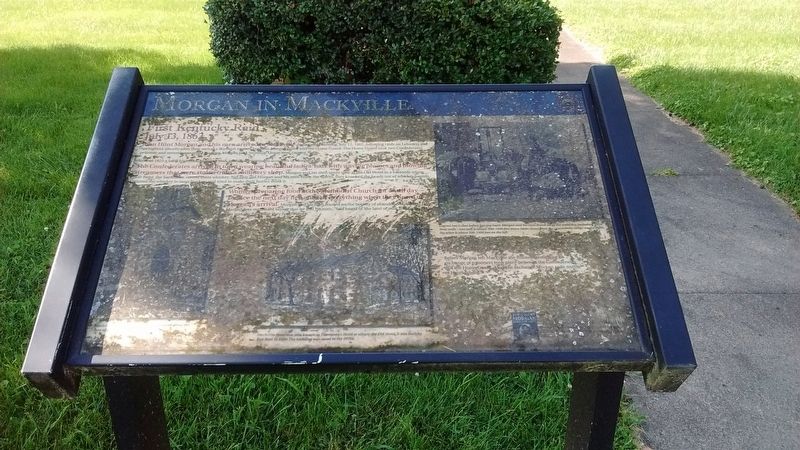
Morgan in Mackville
First Kentucky Raid
— July 13, 1862 —
Around 1925 a local historian, Marshall Hall, recorded eyewitness accounts of Morgan’s stay in Mackville.
The Confederates arrived in town wearing beautiful ladies’ hats with waving plumes and blowing streamers that were stolen from a millinery shop. Morgan and his men spent time at the Old Hotel in a barroom where Bob Reed, the bartender, served them whiskey. Not only did Morgan and his men enjoy the spirits, they knocked the heads out of whiskey barrels, poured the whiskey in large buckets and tried to make their horses drink it.
Women preparing food at the Methodist Church for an all day service the next day fled and left everything when they heard of Morgan’s arrival. Morgan and his men feasted on the bounty of abandoned food and later Morgan was overheard saying that he and his men, "had heard of ‘the land of milk and honey,’ but this was the first time they had found it."
Before Morgan left Mackville the following morning an exchange of prisoners took place between the Confederates and the Home Guard. After the exchange Morgan rode north, to Harrodsburg.
(Captions)
Legend has it that before leaving town, Morgan and his men drank all of the wells dry, including three deep wells – one well is about 500-1000 feet down Main Street from the community center on the right, the other is about 500-1000 feet on the left.
Mackville Hotel was also know as Thompson’s Hotel or simply the Old Hotel. It was built by Bob Reid in 1820. The building was razed in the 1970s.
Mackville Methodist Church as it appeared about the turn of the 20th century.
Erected by Kentucky Heartland Civil War Trails Commission. (Marker Number 31.)
Topics and series. This historical marker is listed in this topic list: War, US Civil. In addition, it is included in the John Hunt Morgan Heritage Trail in Kentucky series list. A significant historical date for this entry is July 13, 1862.
Location. 37° 44.148′ N, 85° 4.215′ W. Marker is unreadable. Marker is in Mackville, Kentucky, in Washington County. Marker is at the intersection of Mackville Hill Road (Kentucky Route 152) and Mackville Elementary School Drive, on the right when traveling east on Mackville Hill Road. Touch for map. Marker is at or near this postal address: 10651 Main St, Mackville KY 40040, United States of America. Touch for directions.
Other nearby markers. At least 8 other markers are within 7 miles of this location, measured as the crow flies. Starkweather's Wall: Highwatermark of the West (approx. 6.6 miles away); Defense of Parsons’ Ridge (approx. 6.7 miles away); Starkweather’s Hill (approx. 6.7 miles away); Dixville Crossroads (approx. 6.7 miles away); On this Spot Brig. Gen. James S. Jackson Fell (approx. 6.7 miles away); Illinois Soldiers at Perryville (approx. 6.7 miles away); a different marker also named Defense of Parsons’ Ridge (approx. 6.7 miles away); The Cornfield (approx. 6.7 miles away).
Also see . . . Link to web page where clear photo of marker is shown. Scroll to bottom of page. (Submitted on February 22, 2024, by Mark Hilton of Montgomery, Alabama.)
Additional commentary.
1. Robert Reed owner of the Robert Reed Hotel in Maxville/Mackville, Kentucky
Robert Reed was born in Ireland. He married Nancy Peter 18 September 1832 in Washington County, Kentucky. They raised their children in Washington County. Robert died in that county in 1865. Nancy runs the hotel a short while before she sells it in 1867 and moves to Jackson County, Missouri. The name of the hotel at that time is the "Robert Reed Hotel" as stated in the deed Power of Attorney record. She sold it to Preston and Paris Peter for $100. Preston and Paris are related to Nancy. William Sweeney, Nancy's Power of Attorney, sells the hotel for her since she is living in Missouri now. Robert and Nancy are my 3rd great grandparents.
— Submitted February 21, 2024, by Anita Chambers of Saint Joseph, Missouri.
Credits. This page was last revised on March 12, 2024. It was originally submitted on July 12, 2020, by Tom Bosse of Jefferson City, Tennessee. This page has been viewed 640 times since then and 156 times this year. Photos: 1, 2, 3. submitted on July 12, 2020, by Tom Bosse of Jefferson City, Tennessee. • Bernard Fisher was the editor who published this page.


