Wharton Township near Farmington in Fayette County, Pennsylvania — The American Northeast (Mid-Atlantic)
The French Attack
Fort Necessity National Battlefield
— National Park Service, U.S. Department of the Interior —
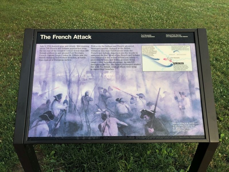
July 3, 1754 dawned gray and drizzly. Mid-morning about 700 French and Indians approached from the far end of the meadow toward fewer than 400 British soldiers in and around Fort Necessity. French Captain Louis Coulon de Villiers saw the British standing before their trenches, in battle lines typical of European tactics.
With a cry the Indians and French advanced. Strategies quickly changed as the British withdrew into their fortifications while the French and Indians dispersed into the woods to surround the fort. Most of the French and Indians concentrated in the woods behind you where — protected by trees and within accurate firing range — they held the advantage. As rain fell throughout the day, the French exchanged musket fire with the British, most of whom were lying in water-filled trenches.
[Sidebar:]
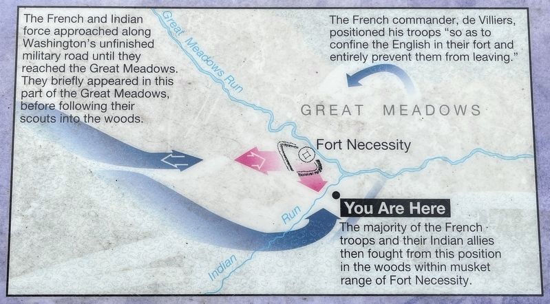
The French and Indian force approaching along Washington's unfinished military road until they reached the Great Meadows. They briefly appeared in this part of the Great Meadows, before following their scouts into the woods.
The French commander, de Villiers, positioned his troops "so as to continue the English in their fort and entirely prevent them from leaving."
You Are Here
The majority of the French troops and their Indian allies then fought from this position in the woods within musket range of Fort Necessity.
[Caption:]
When not firing at the British in and around Fort Necessity, the French and Indians shot the British army's horses, cattle, and dogs in this meadow.
Erected by National Park Service, U.S. Department of the Interior.
Topics. This historical marker is listed in these topic lists: Colonial Era • Forts and Castles • War, French and Indian. A significant historical date for this entry is July 3, 1754.
Location. 39° 48.878′ N, 79° 35.347′ W. Marker is near Farmington, Pennsylvania, in Fayette County. It is in Wharton Township. Marker can be reached from Washington Parkway, 0.4 miles west of National Pike (U.S. 40), on the right when traveling west. Touch for map. Marker is in this post office area: Farmington PA 15437, United States of America. Touch for directions.
Other nearby markers. At least 8 other markers are within walking distance of this marker. British Defenses (a few steps from this marker); Surrender Negotiations (a few steps from this marker); Fort Necessity (within shouting distance of this marker); Building Fort Necessity (within shouting distance of this marker); Civilian Conservation Corps at Fort Necessity (about 700 feet away, measured in a direct line); Do you measure up in Washington's Army? / Are you dressed for the campaign?
(about 700 feet away); The Great Meadows Campaign (about 800 feet away); Fort Necessity National Battlefield (approx. 0.2 miles away). Touch for a list and map of all markers in Farmington.
Credits. This page was last revised on February 7, 2023. It was originally submitted on July 13, 2020, by Devry Becker Jones of Washington, District of Columbia. This page has been viewed 159 times since then and 12 times this year. Photos: 1. submitted on July 13, 2020, by Devry Becker Jones of Washington, District of Columbia. 2. submitted on October 9, 2022, by Craig Swain of Leesburg, Virginia. 3. submitted on July 13, 2020, by Devry Becker Jones of Washington, District of Columbia.


