Milton in Santa Rosa County, Florida — The American South (South Atlantic)
Arcadia Dam and Water Works
Arcadia Mill Archaeological Site
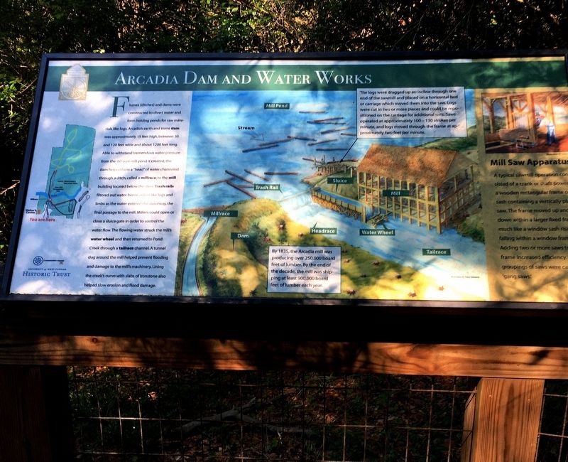
Flumes (ditches) and dams were constructed to divert and form holding ponds for raw materials like logs. Arcadia’s earth and stone dam was approximately 15 foot high, between 30 and 120 feet wide and about 1200 feet long. Able to withstand tremendous water pressure from the 60 acre mill pond it created, the dam helped form a “head” of water channeled through a ditch, called a millrace to the mill building located below the dam. Trash rails filtered out water-borne debris like logs and limbs as the water entered the sluiceway, the final passage to the mill. Millers could open or close a sluice gate in order to control the water flow. The flowing water struck the mill’s water wheel and then returned to Pond Creek through a tailrace channel. A tunnel dug around the mill helped prevent flooding and damage to the mill’s machinery. Lining the creek’s curve with slabs of ironstone also helped slow erosion and flood damage.
By 1835, the Arcadia mill was producing over 250,000 board feet of lumber. By the end of the decade, the mill was shipping at least 900,000 board feet of lumber each year.
The logs were dragged up an incline through one end of the sawmill and placed on a horizontal bed or carriage which moved them into the saw. Logs were cut in two or more pieces and could be repositioned on the carriage for additional cuts. Saws operated at approximately 100-130 strokes per minute, and logs moved through the frame at approximately two feet per minute.
Mill Saw Apparatus
A typical sawmill operation consisted of a crank or shaft powered a wooden rectangular frame or sash containing a vertically placed saw. The frame moved up and down within a larger fixed frame. Adding two or more saws to the frame increased efficiency. These groupings of saws were called “gang saws.”
Erected by University of West Florida Historic Trust.
Topics. This historical marker is listed in these topic lists: Anthropology & Archaeology • Horticulture & Forestry • Industry & Commerce.
Location. 30° 36.819′ N, 87° 5.003′ W. Marker is in Milton, Florida, in Santa Rosa County. Marker can be reached from Mill Pond Lane, 0.1 miles north of Juan De Laurua Court when traveling north. Marker located within the Arcadia Mill Archaeological Site. Touch for map. Marker is at or near this postal address: 5709 Mill Pond Lane, Milton FL 32583, United States of America. Touch for directions.
Other nearby markers. At least 8 other markers are within walking distance of this marker. Arcadia Community (within shouting distance of this marker); Arcadia Mill (within shouting distance of this marker); Existing Foundations: Sawmill and Textile Mill (within shouting distance of this marker); Arcadia Dam (within shouting distance of this marker); The Millrace (within shouting distance of this marker); Elliott’s Flume (about 400 feet away, measured in a direct line); Plunge Pool (about 500 feet away); Arcadia’s Cotton Textile Mill (about 500 feet away). Touch for a list and map of all markers in Milton.
Also see . . . Historic Pensacola - Explore Arcadia Mill. University of West Florida Historic Trust (Submitted on July 14, 2020.)
Credits. This page was last revised on July 15, 2020. It was originally submitted on July 14, 2020, by Brandon D Cross of Flagler Beach, Florida. This page has been viewed 186 times since then and 19 times this year. Photos: 1, 2, 3. submitted on July 14, 2020, by Brandon D Cross of Flagler Beach, Florida. • Bernard Fisher was the editor who published this page.


