Bismarck to Deadwood Stage Trail
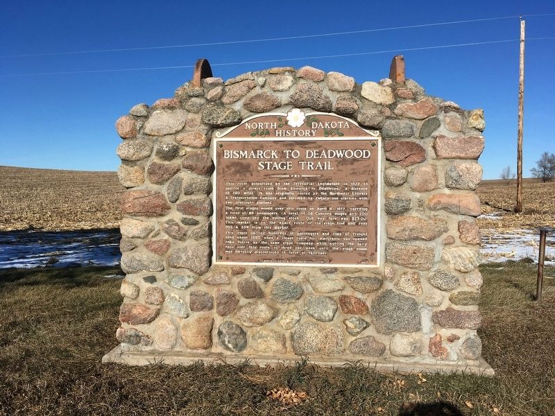
The first stages moved over this route on 11 April 1877, carrying 68 passengers. A total of 26 Concord Stages and 200 teams comprised the rolling stock. One way fare was $23.00. This marker is on the exact route of the stage line and runs NNE & SSE from this marker.
This route carried hundreds of passengers and tons of freight until about 1880 when a closer route for immigrants from Pierre, SD by the same company while cutting the daily runs over this route to three per week until the stage route was virtually discontinued in favor of railroads.
Erected 1962 by North Dakota State Historical Society.
Topics. This historical marker is listed in this topic list: Roads & Vehicles. A significant historical year for this entry is 1877.
Location. 46° 27.523′ N, 101° 13.154′ W. Marker is near Flasher, North
this page online

Regionally, this marker is on the Missouri Plateau and in Greater Bismarck Area. It is also in the American Lewis & Clark Corridor, on the prairies, and on the Northern Plains. Globally, it is in North America, the Western Hemisphere, the Western World, and the Anglosphere. Historically, it finds itself in what was once Rupert’s Land and also the Louisiana Purchase.
Other nearby markers. At least one other marker is within walking distance of this marker: Flasher Centennial Railroad Park (approx. 0.8 miles away).
Also see . . . Bismarck-Deadwood Stage Marker. (Submitted on August 2, 2020, by Connor Olson of Menomonee Falls, Wisconsin.)
Credits. This page was last revised on August 3, 2020. It was originally submitted on July 18, 2020, by Connor Olson of Menomonee Falls, Wisconsin. This page has been viewed 638 times since then and 49 times this year. Photos: 1, 2. submitted on July 18, 2020, by Connor Olson of Menomonee Falls, Wisconsin. • Mark Hilton was the editor who published this page.
