Near Hesperus in La Plata County, Colorado — The American Mountains (Southwest)
Dominguez and Escalante
Photographed by Duane Hall, October 10, 2010
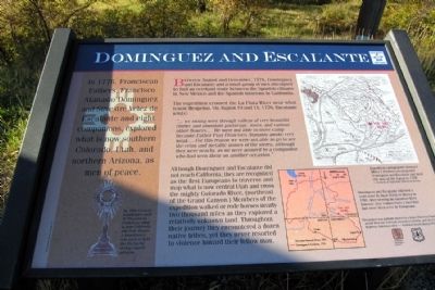
1. Dominguez and Escalante Marker
In 1776, Franciscan Fathers, Francisco Atanasio Dominguez and Silvestre Velez de Excalante and eight companions, explored what is now southern Colorado, Utah, and northern Arizona, as men of peace.
Between August and December, 1776, Dominguez and Escalante and a small group of men attempted to find an overland route between the Spanish villages in New Mexico and the Spanish missions in California.
The expedition crossed the La Plata River near what is now Hesperus. On August 10 and 11, 1776, Escalante wrote:
"... we swung west through the valleys of very beautiful timber and abundant pasturage, roses, and various other flowers.... We were not able to move camp because Father Fray Francisco Atanasio awoke very weak.... For this reason we were not able to go to see the veins and metallic stones of the sierra, although they were nearby, as we were assured by a companion who had seen them on another occasion."
Although Dominguez and Escalante did not reach California, they are recognized as the first Europeans to traverse and map what is now central Utah and cross the mighty Colorado River, (northeast of the Grand
this page online
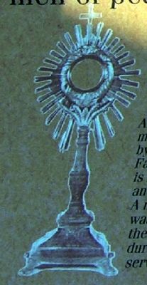
Left caption
An 18th Century monstrance used by Franciscan Fathers in what is now California and New Mexico. A monstrance was used to hold the Eucharist during church services.
Upper right map caption
Expedition cartographer Bernard Miera Y Pacheco accompanied Dominguez and Escalante and drew this map of the region in 1778.
– Courtesy of Utah State Historical Society
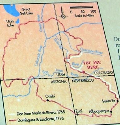
Lower right Map caption
Dominguez and Escalante followed a route used by Juan Maria de Rivera in 1765. After crossing the Gunnison River, however, they ventured into a land that had never been seen by Europeans.
Erected by Colorado Historical Society and United States Forest Service.
Topics and series. This historical marker is listed in these topic lists: Colonial Era • Exploration. In addition, it is included in the Dominguez y Escalante Expedition series list. A significant historical month for this entry is December 1776.
Location. This marker has been replaced by another marker nearby.
Photographed by Duane Hall, October 10, 2010
2. 18th Century Monstrance

Regionally, this marker was in the American Mountain West and at the Four Corners. Globally, it was in North America, the Rocky Mountains, the Western Hemisphere, the Western World, and the Anglosphere. Historically, it found itself in what was once the territory of the Ancestral Puebloans.
Other nearby markers. At least 8 other markers are within 9 miles of this location, measured as the crow flies: Dominguez & Escalante (here, next to this marker); Dominguez-Escalante Expedition (here, next to this marker); The Old Spanish Trail (here, next to this marker); Fort Lewis College (approx. 8 miles away); Cedar Grove Cemetery Veterans' Memorial (approx. 8½ miles away); 1892 Horse-Drawn Pull Grader (approx. 8.7 miles away); Hard Pressed (approx. 8.7 miles away); Bauer Bank Building (approx. 8.7 miles away). Touch for a list and map of all markers in Hesperus.
More about this marker. Marker is an interpretive sign on the San Juan Skyway scenic highway.
Also see . . . Dominguez - Escalante Expedition - Wikipedia entry. (Submitted on February 6, 2014.)
Additional commentary.
1. Dominguez and Escalante Marker
The marker states, “This project was partially funded by a State Historical Fund award from the Colorado Historical Society and the Federal Highway Administration - National Scenic Byway Program."
— Submitted February 6, 2014.

Photographed by Duane Hall, October 10, 2010
3. Bernard Miera y Pacheco 1778 Map
Photographed by Duane Hall, October 10, 2010
4. Route of Dominguez-Escalante Expedition
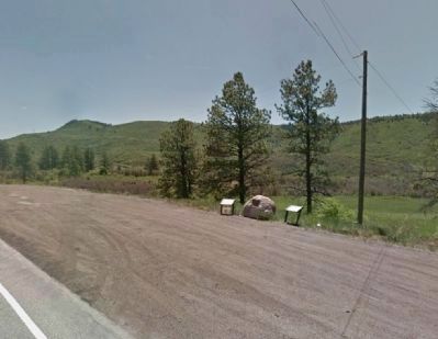
Google Street View (©2014 Google), June 2012
5. View to Southeast from US 160
Credits. This page was last revised on December 2, 2025. It was originally submitted on February 6, 2014. This page has been viewed 1,892 times since then and 90 times this year. Last updated on July 21, 2020, by Duane and Tracy Marsteller of Murfreesboro, Tennessee. Photos: 1, 2, 3, 4, 5. submitted on February 6, 2014, by Duane Hall of Abilene, Texas. • J. Makali Bruton was the editor who published this page.
