Ogdensburg in St. Lawrence County, New York — The American Northeast (Mid-Atlantic)
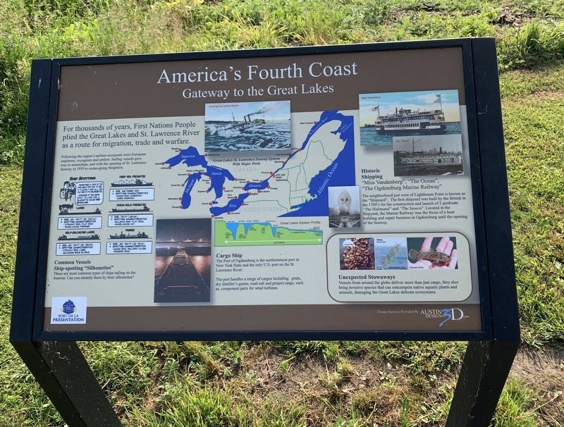
America’s Fourth Coast
Gateway to the Great Lakes
For thousands of years, First Nations People plied the Great Lakes and St. Lawrence River as a route for migration, trade and warfare.
Following the region's earliest occupants were European explorers, voyageurs and settlers. Sailing vessels gave way to steamships, and with the opening of St. Lawrence Seaway in 1959 to ocean-going freighters.
Cargo Ship
The Port of Ogdensburg is the northernmost port in New York State and the only U.S. port on the St. Lawrence River.
The port handles a range of cargos including: grain, road salt, and project cargo, such as, component parts for wind turbines.
Historic Shipping
"Miss Vandenberg", "The Ocean", "The Ogdensburg Marine Railway"
The neighborhood just west of Lighthouse Point is known as the "Shipyard". The first shipyard was built by the British in the 1760's for the construction and launch of 2 gunboats "The Halimand” and "The Seneca". Located in the Shipyard, the Marine Railway was the focus of a boat building and repair business in Ogdensburg until the opening of the Seaway.
Unexpected Stowaways
Vessels from around the globe deliver more than just cargo, they also bring invasive species that can outcompete native aquatic plants and animals, damaging the Great Lakes delicate ecosystems.
Photos: Zebra Mussel - Spiny Water Flea- Round Goby
Photos and Illustrations (top center going counter-clockwise);
- Shooting the LaChine Rapids
- Great Lakes St. Lawrence Seaway System With Major Ports
- Great Lakes System Profile
- The "Ocean”
- "Miss Vandenberg"
Common Vessels
Ship-spotting "Silhouettes"
These are most common types of ships sailing on the Seaway. Can you identify them by their silhouettes?
Ship Spotting
Sometimes a ship is too far away for you to see it clearly and all you can see is its silhouette. However, if you know what to look for, a silhouette can be very revealing.
Deep Sea Freighter
* Size And Cargo Vary.
* Spotting Characteristics
- Raked Bow
- Numerous Cargo Derricks.
Ocean Bulk Freighter
* Sze : 740 ft ( 225.5 m)
* Spotting Characteristics
- Bulbous Bow, Flat Deck
- Wheelhouse Aft
Laker
* Size : 600 -740 ft (183-255 m)
* Spotting Characteristics
- Straight Bow, Flat Deck
- Wheelhouse Forward
Self-Unloading Laker
* Size : 600 - 740 ft (183-225.5 m )
* Spotting Characteristics
-Straight Bow
- Large Unloading Boom On Deck
Tanker
* Size : 400 - 500 ft ( 122-153 m)
* Spotting Characteristics
- Raked Bow, Walkway Along Rounded Deck.
Topics. This historical marker is listed in this topic list: Waterways & Vessels. A significant historical year for this entry is 1959.
Location. 44° 41.749′ N, 75° 30.234′ W. Marker is in Ogdensburg, New York, in St. Lawrence County. Marker can be reached from New York State Route 68. In the Fort de la Présentation Park. Touch for map. Marker is at or near this postal address: Abbe Picquet Walking Trail, Ogdensburg NY 13669, United States of America. Touch for directions.
Other nearby markers. At least 8 other markers are within walking distance of this marker. Abbe Picquet 1708 -1781 (about 600 feet away, measured in a direct line); Railroads Come To The North Country (about 700 feet away); Mission Fort (about 800 feet away); Fort de la Présentation (approx. 0.2 miles away); Fort la Présentation (approx. 0.2 miles away); Fort de la Présentation - 1749-1759 (approx. 0.2 miles away); Fort Lévis - 1760 (approx. 0.2 miles away); Fort Oswegatchie 1760-1796 (approx. 0.2 miles away). Touch for a list and map of all markers in Ogdensburg.
Credits. This page was last revised on July 25, 2020. It was originally submitted on July 22, 2020, by Steve Stoessel of Niskayuna, New York. This page has been viewed 232 times since then and 31 times this year. Photo 1. submitted on July 22, 2020, by Steve Stoessel of Niskayuna, New York. • Bill Pfingsten was the editor who published this page.
