Klamath Falls in Klamath County, Oregon — The American West (Northwest)
Klamath Basin History
Agriculture
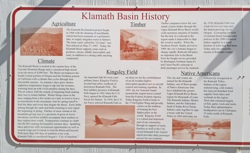
The Klamath Reclamation project began in 1906 with the draining of marshlands, which had been remnants of a prehistoric lake, to supply irrigation water to farmers. The main canal, called the “A Canal,” was first utilized on May 22, 1907. Today, the Klamath Basin supports crops such as potatoes, onions, alfalfa, horseradish, and mint, in addition to a strong cattle ranching community.
Climate
The Klamath Basin is nestled at the eastern base of the Cascade Mountain Range and is considered high desert at an elevation of 4,090 feet. The Basin encompasses the South Central portion of Oregon and the Northern portion of California with the climate that cycles through four discernible seasons. As autumn's days grow shorter, nighttime temperatures begin to dip into the twenties, warming back up with vivid sunshine during the days. The air echoes with the sounds of migrating birds making their way to winter habitat. Winter brings snow to the area, ranging from a few inches at a time in town to heavy accumulations in the mountains vital for spring runoff to feed the lakes and rivers that irrigate the Basin. Early bulbs poking through the earth and birds returning to nest signal the beginning of spring. Patches of snow remain in the mountains giving way to a spectrum of green at lower elevations; newborn wildlife accompany their mothers as they explore their world. Temperatures continue to climb into the 80’s making for beautiful summer days. Sparkling lakes and rivers offer recreational opportunities as well as nourish crops and livestock to feed the Basin and beyond. With more than 300 days of sunshine every year, Klamath Falls is considered Oregon's “City of Sunshine.”
Kingsley Field
An important link for west coast military bases, Kingsley Field is located four miles southeast of downtown Klamath Falls. The first military presence in Klamath Falls began in 1942 when the U.S. Navy opened the Klamath Falls Naval Air Station. IN 1954, the U.S. Air Force selected Klamath Falls as an ideal site for the establishment of an all-weather-fighter-interceptor-squadron and an aircraft control and warning squadron. In 1995, the Air National Guard assumed the airport tower control from the Federal Aviation Agency. Today Kingsley Field is home to the 173rd Fighter Wing and proudly carries on the tradition of training the best fighter pilots in the world. Kingsley Field is a valued and important part of our community through its support of many families as well as the City owned Klamath Falls Airport which provides daily passenger service for our residents.
Timber
Timber companies knew the vast stands of pine
timber through the Upper Klamath River Basin would yield enormous amounts of lumber, but the lack of a railroad in the region made it impossible to ship the wood to market. When the Southern Pacific finally arrived in 1909, the city's fortunes began to change rapidly. Railroad still plays an important role in the Basin from the freight service provided by Burlington Northern Santa Fe and Union Pacific railroads to daily passenger service by Amtrack. By 1930, Klamath Falls was a hub for two rail lines and the fastest growing city in Oregon. A sweeping revision of national forest management policies in the 1990’s reduced timber supplies to a small fraction of what they had been. Today only two sawmills remain in Klamath County.
Native Americans
The city and county are named for the Klamath Indians, one of the three groups of Native Americans who have inhabited the greater Upper Klamath River Basin region for thousands of years. The Klamath Indians, Modoc Indians, and the Yahooskin band of Snake River Paiute Indians came together to sign a treaty with the United States in 1864 and today are collectively recognized as the Klamath Tribes. Indians of the region endured long, cold winters but enjoyed abundant food supplies from lakes and wetlands in the region. Their diet consisted largely of fish, game, roots and seeds. Today their administrative headquarters are
in Chiloquin, 25 miles north of Klamath Falls.
Topics. This historical marker is listed in these topic lists: Agriculture • Air & Space • Horticulture & Forestry • Native Americans. A significant historical date for this entry is May 22, 1907.
Location. 42° 13.149′ N, 121° 47.299′ W. Marker is in Klamath Falls, Oregon, in Klamath County. Marker is on Klamath Avenue, on the right when traveling east. Touch for map. Marker is in this post office area: Klamath Falls OR 97601, United States of America. Touch for directions.
Other nearby markers. At least 8 other markers are within walking distance of this marker. George Nurse (In Memory of) (about 400 feet away, measured in a direct line); Veterans Memorial (about 500 feet away); Locomotive 2579 (about 500 feet away); Pioneer Furtrader (about 700 feet away); Klamath Falls City Hall (approx. 0.4 miles away); Klamath Falls City Library (approx. 0.4 miles away); Whitlock House (approx. half a mile away); Marion Apartments (approx. half a mile away). Touch for a list and map of all markers in Klamath Falls.
Credits. This page was last revised on July 28, 2020. It was originally submitted on July 25, 2020, by Douglass Halvorsen of Klamath Falls, Oregon. This page has been viewed 122 times since then and 13 times this year. Photos: 1, 2, 3. submitted on July 25, 2020, by Douglass Halvorsen of Klamath Falls, Oregon. • J. Makali Bruton was the editor who published this page.


