Archaeological Excavations in 1905
Double Ditch State Historic Site
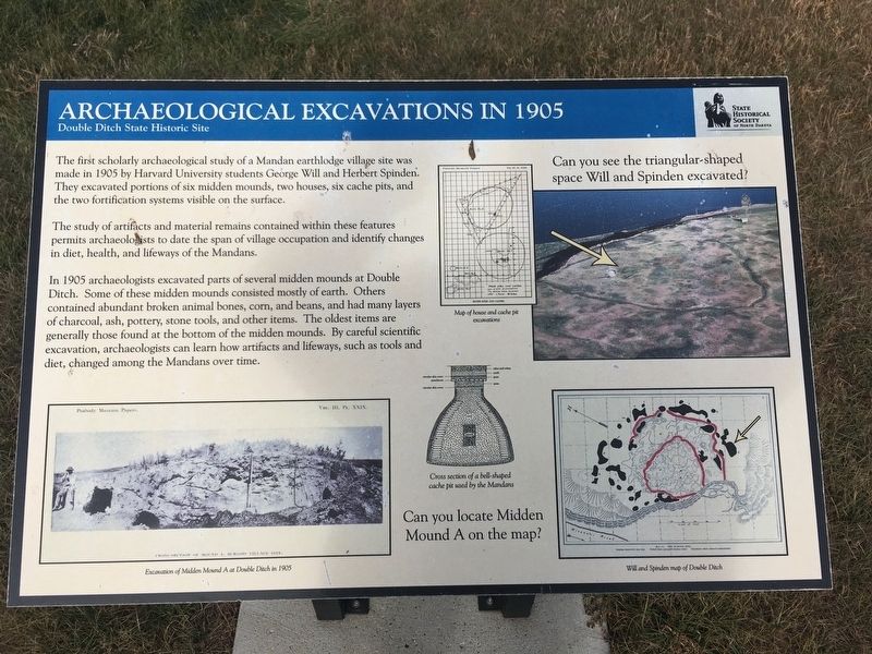
The study of artifacts and material remains contained within these features permits archaeologists to date the span of village occupation and identify changes in diet, health, and lifeways of the Mandans.
In 1905 archaeologists excavated parts of several midden mounds at Double Ditch. Some of these midden mounds consisted mostly of earth. Others contained abundant broken animal bones, corn, and beans, and had many layers of charcoal, ash, pottery, stone tools, and other items, The oldest items are generally those found at the bottom of the midden mounds. By careful scientific excavation, archeologists can learn how artifacts and lifeways, such as tools and diet, changed among the Mandans over time.
Photo captions:
Top Right: Can you see the triangular-shaped space Will and Spinden excavated?
Lower left: Excavation of Midden Mound A at Double Ditch in 1905
Upper middle: Map of house and cache pit excavations
Lower middle: Cross section of a bell-shaped cache pit
used by the Mandans
Lower right: Will and Spinden map of Double Ditch
Can you locate Midden Mound A on the map?
Erected by State Historical Society of North Dakota.
Topics. This historical marker is listed in these topic lists: Anthropology & Archaeology • Native Americans. A significant historical year for this entry is 1905.
Location. 46° 56.113′ N, 100° 53.962′ W. Marker is near Bismarck, North Dakota, in Burleigh County. Marker can be reached from State Highway 1804, 1.1 miles south of Double Ditch Loop, on the right when traveling north. Touch for map. Marker is in this post office area: Bismarck ND 58503, United States of America. Touch for directions.
Other nearby markers. At least 8 other markers are within walking distance of this marker. Final Occupation of Double Ditch (within shouting distance of this marker); Homes (within shouting distance of this marker); Ditch 2 (about 300 feet away, measured in a direct line); Missouri River Resources (about 400 feet away); Geophysical Prospecting in Archaeology (about 500 feet away); Ditch 3 (about 600 feet away); Stone Shelter (about 600 feet away); Double Ditch State Historic Site (about 600 feet away). Touch for a list and map of all markers in Bismarck.
Also see . . . Double Ditch State Historic Site. (Submitted on August 14, 2020, by Connor Olson of Kewaskum, Wisconsin.)
Credits. This page was last revised on August 15, 2020. It was originally submitted on August 14, 2020, by Connor Olson of Kewaskum, Wisconsin. This page has been viewed 153 times since then and 10 times this year. Photos: 1, 2. submitted on August 14, 2020, by Connor Olson of Kewaskum, Wisconsin. • Mark Hilton was the editor who published this page.
Editor’s want-list for this marker. A wide shot of the marker and its surroundings. • Can you help?

