
Near Petersburg in Prince George County, Virginia — The American South (Mid-Atlantic)
The Siege of Petersburg
| — | Petersburg National Battlefield | — |
Photographed by Craig Swain, November 22, 2008
1. The Siege of Petersburg Marker
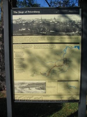
"I would not believe before I came here that man was capable of enduring so much."If Petersburg fell, the Confederate capital at Richmond would fall too. Grant knew it; Lee knew it. And for nine months in 1864 and 1865 Union and Confederate armies waged a brutal campaign here that left the Confederacy on the verge of total defeat.
-Lawrence Bradley, 1st Mass. Heavy Artillery
At Petersburg, the war in Virginia transformed from a whirlwind succession of marches and battles into a methodical struggle of endurance and hardship.
Touring the Battlefield
Petersburg National Battlefield includes four major historic areas. A driving tour links the main park unit, Five Forks Battlefield, and Flank and Defense Roads.
The City Point Unit is located eight miles northeast of the visitor center in the city of Hopewell. You can start your visit in the visitor center, where brochures and additional tour information are available.
Erected by National Park Service, U.S. Department of the Interior.
Topics. This historical marker is listed in this topic list: War, US Civil. A significant historical month for this entry is June 1864.
Location. This marker has been replaced by another marker nearby.
this page online

Regionally, this marker was in Coastal Virginia. It was also in the American South, specifically in the Upper South, in the Tidewater, and on the Eastern Seaboard. Globally, it was in the North Atlantic Region, North America, the Western Hemisphere, the Western World, and the Anglosphere. Historically, it found itself in what was once the territory of the Mississippian Culture, one of the original Thirteen Colonies, one of the Confederate States of America, and the Antebellum South.
Other nearby markers. At least 8 other markers are within walking distance of this location: A different marker also named The Siege of Petersburg
Photographed by Craig Swain, November 22, 2008
2. Park Map
Other markers no longer nearby. Battery 5 Trail (was within shouting distance of this marker but has been replaced with another marker now near it); a different marker also named Uprooted by War (was about 300 feet away, measured in a direct line but has been replaced with another marker now near it).
More about this marker. In the upper portion of the marker is a wartime photo of The prize: Petersburg.
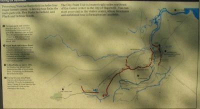
In the center is a map of Petersburg National Battlefield Park showing the locations of the park units.
(1) The main park unit includes sites that span the entire siege, including the Union capture of part of the Dimmock Line in June 1864, the spectacular blast at the "Crater" in July, and Lee's last offensive, at Fort Stedman, in March 1865.
(2) Flank Road and Defense Road link fortifications and battle sites related to the Union's incessant efforts to cut the rail lines leading into Petersburg - efforts that ultimately stretched the Confederate defense lines to their breaking point.
(3) At Five Forks on April 1, 1865 the Union army defeated and scattered one-fifth of Lee's entire force. Petersburg and Richmond fell within two days.
(4) During the siege, City Point was one of the busiest ports in America. From his headquarters there, Ulysses S. Grant directed the movement of Union armies throughout the South.
In
Photographed by Craig Swain, November 22, 2008
3. The Siege of Petersburg Marker
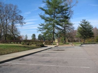
From the parking lot.
Related marker. Click here for another marker that is related to this marker. New Replacement Marker At This Location also titled "The Siege of Petersburg".
Also see . . . Battle and Siege of Petersburg. National Park Service site. (Submitted on December 21, 2008, by Craig Swain of Leesburg, Virginia.)
Photographed by Craig Swain, November 22, 2008
4. Stephen Tyng Mather
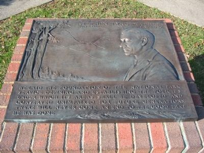
On the walk to the Visitor Center is this memorial to Stephen Mather. Mather was the first director of the National Park Service. It reads:
July 4, 1867 - Jan. 22, 1930
He laid the foundation of the National Park Service, defining and establishing the policies under which its areas shall be developed and conserved unimpaired for future generations. There will never come an end to the good that he has done.
July 4, 1867 - Jan. 22, 1930
He laid the foundation of the National Park Service, defining and establishing the policies under which its areas shall be developed and conserved unimpaired for future generations. There will never come an end to the good that he has done.
Credits. This page was last revised on October 21, 2024. It was originally submitted on December 21, 2008. This page has been viewed 1,788 times since then and 42 times this year. Last updated on August 25, 2020, by Bradley Owen of Morgantown, West Virginia. Photos: 1, 2, 3. submitted on December 21, 2008, by Craig Swain of Leesburg, Virginia. 4. submitted on December 22, 2008, by Craig Swain of Leesburg, Virginia. • J. Makali Bruton was the editor who published this page.
