Cecilton in Cecil County, Maryland — The American Northeast (Mid-Atlantic)
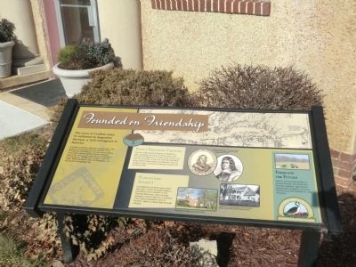
Founded on Friendship
Chesapeake Country National Scenic Byway
Photographed by Don Morfe, January 30, 2015
1. Founded on Friendship Marker
The town of Cecilton owes its existence to Augustine Herman, a 1633 immigrant to America.
A wealthy merchant, diplomat, cartographer, and explorer, he also proposed the creation of the Chesapeake and Delaware Canal a century before it was built. Herman drafted the first detailed map of the Chesapeake region for Lord Baltimore in exchange for 20,000 acres of land--which he called "Bohemia Manor" after his birthplace--in and around Chesapeake City.
Family Followed Through
Herman made several attempts to establish a town named for his friend Cecilius Calvert, the Second Lord Baltimore, in lower Cecil County, but was not successful. It was not until after Herman's death that his descendants founded the Town of Cecilton at the crossroads of Maryland Route 213 and Route 282.
Plantations Aplenty
Lord Baltimore favored many others with gifts of land, and great tobacco plantations were common in the Sassafras River area. One surviving example is Mount Harmon, a restored 17th century plantation west of Cecilton, open to visitors May through October.
Farms for the Future
Land in and around Cecilton is actively farmed, and much of
this page online
[Captions:]
Augustine Herman, left, and Cecilius Calvert, Second Lord Baltimore, right. Copyright expired (both images).
Mount Harmon. Image courtesy Steve Gotlieb.
Homestead of Augustine Herman, Bohemia Manor. Image courtesy Cecil County Historical Society.
Topics and series. This historical marker is listed in these topic lists: Colonial Era • Settlements & Settlers. In addition, it is included in the Chesapeake & Delaware (C&D) Canal series list. A significant historical year for this entry is 1633.
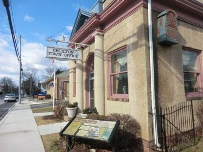
Location. Marker has been permanently removed. It was located near 39° 24.261′ N, 75° 52.114′ W. Marker was in Cecilton, Maryland, in Cecil County. It was on W. Main Street (Maryland Route 282) west of Bohemia Avenue ( Route 213), on the right when traveling west. The marker is in front of the Cecilton Town Office. Touch for map. Marker was at or near this postal address: 117 W Main Street, Cecilton MD 21913, United States of America.
We have been informed that this marker is no longer there and will not
Photographed by Don Morfe, January 30, 2015
2. Founded on Friendship Marker
Regionally, this marker was in Greater Wilmington, on the Eastern Shore, and in Greater Philadelphia. It was also in the American Mid-Atlantic, on the Delmarva Peninsula, in the Tidewater, in the Chesapeake Bay Region, and on the Eastern Seaboard. Globally, it was in the North Atlantic Region, North America, the Western Hemisphere, the Western World, and the Anglosphere. Historically, it found itself in what was once one of the original Thirteen Colonies and also the Antebellum South.

Other nearby markers. At least 8 other markers are within 3 miles of this location, measured as the crow flies: Cpl Brandon Michael Craig (within shouting distance of this marker); Union Bethel African Methodist Episcopal Church (about 800 feet away, measured in a direct line); Greenfield (approx. one mile away); The Anchorage (approx. 1.4 miles away); St. Francis Xavier Church (approx. 2 miles away); “Worsell Mannor” (approx. 2.2 miles away); Sassafras River (approx. 2.8 miles away); Mount Pleasant (approx. 2.9 miles away). Touch for a list and map of all markers in Cecilton.
Credits. This page was last revised on July 25, 2026. It was originally submitted on February 2, 2015, by Don Morfe of Baltimore, Maryland. This page has been viewed 1,164 times since then and 51 times this year. Last updated on August 30, 2020, by Carl Gordon Moore Jr. of North East, Maryland. Photos: 1, 2. submitted on February 2, 2015, by Don Morfe of Baltimore, Maryland. • Bill Pfingsten was the editor who published this page.
