Georgetown in Kent County, Maryland — The American Northeast (Mid-Atlantic)
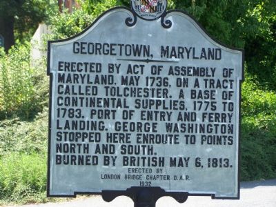
Georgetown, Maryland
Burned by British May 6, 1813.
Erected 1932 by London Bridge Chapter D. A. R.
Topics and series. This historical marker is listed in these topic lists: Colonial Era • War of 1812 • War, US Revolutionary • Waterways & Vessels. In addition, it is included in the Former U.S. Presidents: #01 George Washington, and the George Washington Slept Here series lists. A significant historical date for this entry is May 14, 1736.
Location. 39° 21.688′ N, 75° 52.818′ W. Marker is in Georgetown, Maryland, in Kent County. Marker is at the intersection of Maryland Route 213 and Queen Street, on the right when traveling south on State Route 213. Touch for map. Marker is in this post office area: Georgetown MD 21930, United States of America. Touch for directions.
Other nearby markers. At least 8 other markers are within 3 miles of this marker, measured as the crow flies. Mistress Kitty Knight (within shouting distance of this marker); Daring to Resist (within shouting distance of this marker); A Heavy Price (about 500 feet away, measured in a direct line); Sassafras River (approx. 0.3 miles away); Fort Duffy (approx. 0.4 miles away); Downs’ Cross Roads (approx. 1.4 miles away); Greenfield (approx. 2 miles away); Founded on Friendship (approx. 3 miles away). Touch for a list and map of all markers in Georgetown.
Regarding Georgetown, Maryland. From Carl G. Moore Jr.: It has come to my attention that there is another Georgetown in Kent County, about due west of Chestertown and near Chesapeake Bay and Tolchester Beach. On THIS marker, a tract called Tolchester is mentioned, thus creating a question about the extent of such tract. Both Georgetowns of Kent County, Maryland have wikipedia entries; do not confuse them with the Georgetown which became part of Washington DC.
Credits. This page was last revised on August 31, 2020. It was originally submitted on July 6, 2007, by Bill Pfingsten of Bel Air, Maryland. This page has been viewed 2,452 times since then and 45 times this year. Last updated on August 31, 2020, by Carl Gordon Moore Jr. of North East, Maryland. Photos: 1, 2. submitted on July 6, 2007, by Bill Pfingsten of Bel Air, Maryland.

