Near Spotsylvania Courthouse in Spotsylvania County, Virginia — The American South (Mid-Atlantic)
Harris Farm
Central Virginia Battlefields Trust
Photographed by Bernard Fisher, May 15, 2014
1. Harris Farm Marker
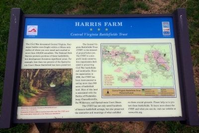
The Central Virginia Battlefields Trust (CVBT) is the steward of ground before you. The CVBT is a non-profit lands conservation organization dedicated to preserving Civil War battlefields and landmarks. Since its organization in 1996, the CVBT has been instrumental in saving more than 900 acres of battlefield land. Most of this land is associated with the Battles of Fredericksburg, Chancellorsville, the Wilderness, and Spotsylvania Court House.
The CVBT has not only saved hundreds of historic battlefield acreage, but also preserved the memories and meanings of what unfolded on these crucial grounds. Please help us to protect these battlefields. To learn more about the CVBT and what you can do, visit our website at www.cvbt.org.
(captions)
(lower
this page online
Thousands of soldiers marched down this road. The CVBT saved this crucial piece of ground on the Wilderness Battlefield.
Erected by Virginia Civil War Trails.
Topics and series. This historical marker is listed in this topic list: War, US Civil. In addition, it is included in the Virginia Civil War Trails series list. A significant historical year for this entry is 1996.
Location. 38° 14.026′ N, 77° 34.12′ W. Marker is near Spotsylvania Courthouse, Virginia, in Spotsylvania County. It is at the intersection of South Harris Farm Road and Pond View Lane, on the right when traveling south on South Harris Farm Road. Touch for map. Marker is at or near this postal address: 9906 South Harris Farm Road, Spotsylvania VA 22553, United States of America. Touch for directions.

Regionally, this marker is in the Washington Metropolitan Area, in Northern Virginia, and in the Piedmont. It is also in the American South, specifically in the Upper South, in the Mid-Atlantic, and on the Eastern Seaboard. Globally, it is in the North Atlantic Region, North America,
Photographed by Bernard Fisher, May 15, 2014
2. Harris Farm Marker
Other nearby markers. At least 8 other markers are within 2 miles of this marker, measured as the crow flies: A different marker also named Harris Farm (here, next to this marker); Pvt. James Z. Branscomb, CSA (about 400 feet away, measured in a direct line); a different marker also named Harris Farm (about 400 feet away); a different marker also named Harris Farm (about 400 feet away); First Regiment Heavy Artillery (about 500 feet away); Engagement at Harris Farm (Bloomsbury) (approx. 0.4 miles away); Landram Farm (approx. 1.4 miles away); Landram House (approx. 1.4 miles away). Touch for a list and map of all markers in Spotsylvania Courthouse.
Other markers no longer nearby. Harris Farm (was about 400 feet away but has been replaced with another marker now near it); a different marker also named Harris Farm (was about 400 feet away but has been replaced
Photographed by Bernard Fisher, May 15, 2014
3. Harris Farm Marker
Also see . . . Central Virginia Battlefield Trust. (Submitted on May 16, 2014.)
Credits. This page was last revised on November 14, 2021. It was originally submitted on May 15, 2014, by Bernard Fisher of Richmond, Virginia. This page has been viewed 1,178 times since then and 60 times this year. Last updated on September 11, 2020, by Bradley Owen of Morgantown, West Virginia. Photos: 1. submitted on May 15, 2014, by Bernard Fisher of Richmond, Virginia. 2, 3. submitted on May 16, 2014, by Bernard Fisher of Richmond, Virginia.
