Squirrel Hill South in Pittsburgh in Allegheny County, Pennsylvania — The American Northeast (Mid-Atlantic)
Welcome to the Frick Woods / Pennsylvania - Forest Land

Photographed By Devry Becker Jones (CC0), September 11, 2020
1. Welcome to the Frick Woods side of the marker
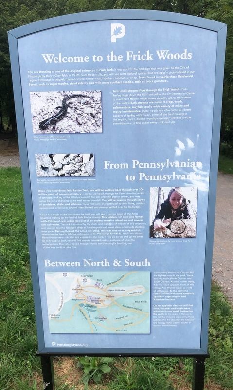
You are standing at one of the original entrances to Frick Park. It was part of the acreage that was given to the City of Pittsburgh by Henry Clay Frick in 1919. From these trails, you will see some natural spaces that are nearly unparalleled in our region. Pittsburgh is uniquely placed where northern and southern habitats overlap. Trees found in the Northern Hardwood Forest, such as sugar maples, stand side by side with more southern species, such as black gum trees.
Two small streams flow through the Frick Woods: Falls Ravine skips down the hill from below the Environmental Center to meet Fern Hollow which moves steadily along the bottom of the valley. Both streams are home to frogs, toads, salamanders, crayfish, and a wide variety of micro and macro invertebrates. These woods are also home to vibrant carpets of spring wildflowers, some of the best birding in the region, and a diverse woodland canopy. There is always something new to find under every rock and log.
From Pennsylvanian to Pennsylvania
When you head down Falls Ravine Trail, you will be walking back through over 300 million years of geological history — all the way back through the Pennsylvanian period of geology. Looking at the hillsides beneath the oak and tulip poplar leaves, you may notice rocks changing as the trail moves downhill. You will be passing through layers of sandstone, shale, and siltstone. These rocks are characterized by their flaky, crumbly appearance, created as ancient rivers and swamps settled over the landscape.
About two-thirds of the way down the trail, you will see a narrow band of the Ames limestone making up the bed of Falls Ravine stream. This calcium-rich rock was formed while Pittsburgh was along the coast of an ancient, massive inland sea and covered with salt water. The rock is created by the shells and skeletons of millions of sea creatures and you can find the fossilized shells of brachiopods and round stems of crinoids studding these rocks. Passing through the Ames limestone, the rocks take on a rusty reddish color from the iron in this layer, known as Pittsburgh Red Beds. This is the oldest Pennsylvanian-era rocks that are exposed in the park. If you go across and up the other hill to Braddock Trail, you will find smooth, rounded rocks — evidence of when the Monongahela River once flowed through what is now Pittsburgh's East End, and all the way north to Lake Erie.
Between North & South
Sounding the top of Clayton Hill, the highest point in the park, there are two trails: North Clayton and South Clayton. AS their names imply,

Photographed By Devry Becker Jones (CC0), September 11, 2020
2. Pennsylvania - Forest Land side of marker
On the opposite side you will find oaks, hickories and tupelo trees, which are found much further into the south. In this area of the park, it is not the distance separating these species; it is the direction the hillsides are facing, which creates colder or warmer microclimates.
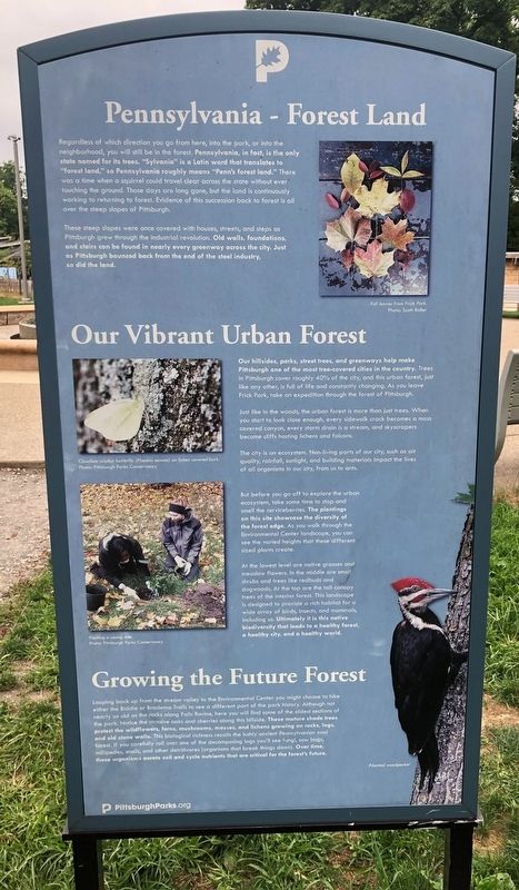
Regardless of which direction you go from here, into the park, or into the neighborhood, you will still be in the forest. Pennsylvania, in fact, is the only state named for its trees. "Sylvania" is a Latin word that translates to "forest land," so Pennsylvania roughly means "Penn's forest land." There was a time when a squirrel could travel clear across the state without ever touching the ground. Those days are long gone, but the land is continuously working to returning to forest. Evidence of this succession back to forest is all over the steep slopes of Pittsburgh.
These steep slopes were once covered with houses, and steps on Pittsburgh grew through the industrial revolution. Old walls, foundations, and stairs can be found in nearly every greenway across the city. Just as Pittsburgh bounced back

Photographed By Devry Becker Jones (CC0), September 11, 2020
3. Welcome to the Frick Woods / Pennsylvania - Forest Land Marker
Our Vibrant Urban Forest
Our hillsides, parks, street trees, and greenways help make Pittsburgh one of the most tree-covered cities in the country. Trees in Pittsburgh cover roughly 40% of the city, and this urban forest, just like any other, is full of life and constantly changing. As you leave Frick Park, take an expedition through the forest of Pittsburgh.
Just like in the woods, the urban forest is more than just trees. When you start to look close enough, every sidewalk crack becomes a moss covered canyon, every storm drain is a stream, and skyscrapers become cliffs hosting lichens and falcons.
The city is an ecosystem. Non-living parts of our city, such as air quality, rainfall, sunlight, and building materials impact the lives of all organisms in our city, from us to ants.
But before you go off to explore the urban ecosystem, take some time to stop and smell the serviceberries. the plantings on this site showcase the diversity of the forest edge. As you walk through the Environmental Center landscape, you can see the varied heights that these different sized plants create.
At the lowest level are native grasses and meadow flowers. In the middle are small shrubs and trees like redbuds and dogwoods. At the top are the tall canopy trees of the interior forest. This landscape is designed to provide a rich habitat for a wide array of birds, insects, and mammals, including us. Ultimately it is the native biodiversity that leads to a healthy forest, a healthy city, and a healthy world.
Growing the Future Forest
Looping back up from the stream valley to the Environmental Center you might choose to hike either the Biddle or Bradema Trails to see a different part of the park history. Although not nearly as old as the rocks along Falls Ravine, here you will find some of the oldest sections of the park. Notice the massive oaks and cherries along this hillside. These mature shade trees protect the wildflowers, ferns, mushrooms, mosses, and lichens growing on rocks, logs, and old stone walls. This biological richness recalls the lushly ancient Pennsylvania coal forest. If you carefully roll over one of the decomposing logs you'll see fungi, sow bugs, millipedes, snails, and other detritivores (organisms that break things down). Over time, these organisms aerate soil and cycle nutrients that are critical for the forest's future.
Erected by Pittsburgh Parks Conservancy.
Topics. This historical marker is listed in these topic lists: Animals • Environment • Horticulture & Forestry • Parks & Recreational Areas. A significant historical year for this entry is 1919.
Location. 40° 26.192′ N, 79° 54.405′ W. Marker is in Pittsburgh, Pennsylvania, in Allegheny County. It is in Squirrel Hill South. Marker can be reached from Beechwood Boulevard, 0.1 miles east of Shaw Avenue, on the right when traveling north. Touch for map. Marker is at or near this postal address: 2005 Beechwood Blvd, Pittsburgh PA 15217, United States of America. Touch for directions.
Other nearby markers. At least 8 other markers are within walking distance of this marker. Park Development (about 300 feet away, measured in a direct line); Frick Park Today (about 300 feet away); Frick Family (about 300 feet away); From Slavery to Freedom Garden (about 400 feet away); a different marker also named From Slavery to Freedom Garden (about 400 feet away); Veterans Memorial (approx. 0.3 miles away); Robert Andrew Woods, M.D. and his wife Grace Lydia Street (approx. 0.4 miles away); a different marker also named Veterans Memorial (approx. 0.4 miles away). Touch for a list and map of all markers in Pittsburgh.
Credits. This page was last revised on February 2, 2023. It was originally submitted on September 14, 2020, by Devry Becker Jones of Washington, District of Columbia. This page has been viewed 316 times since then and 76 times this year. Photos: 1, 2, 3. submitted on September 14, 2020, by Devry Becker Jones of Washington, District of Columbia.