The Sassafras River
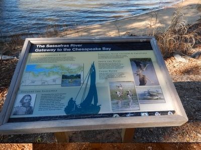
Gateway to the Chesapeake Bay
About the Sassafras River
The Sassafras River is a popular destination for recreation, boating, fishing and waterfowl. The Sassafras River is over 20 miles long and provides critical habitat wildlife and is an important flyway for migrating birds along the Chesapeake Bay. The Sassafras River has brackish water, with primarily fresh water from tributaries mixing with saltier water from the Chesapeake Bay.
Explore the Sassafras
The Sassafras River and its tributaries are great places to explore. The Sassafras is part of the Captain John Smith Chesapeake National Historic Trail, the Star Spangled Banner National Historic Trail and the Sassafras River Water Trail. Explore the Sassafras by kayak or canoe and follow the journies of Captain John Smith and the Tockwogh Indians.
Sassafras River Critters & Creatures
The Sassafras River is home to a wide array of wildlife and migrating birds, so be sure to keep your eyes out for some of our furry, finned, and feathered friends.
Above the Water
Above the water, be on the look out for white-tailed deer, great blue herons, red fox, bald eagles, osprey, red-tailed hawks, Canada geese, wood ducks, mallards, tundra swans, and a whole host of migrating birds.
Under Water
Under the water’s surface is an important ecosystem and nursery
[map caption] This map is intended as a reference source only and is not to be used as an aid for navigation.
Topics and series. This historical marker is listed in these topic lists: Animals • Environment • Waterways & Vessels. In addition, it is included in the Captain John Smith Chesapeake National Historic Trail series list.
Location. 39° 22.762′ N, 75° 56.254′ W. Marker is in Earleville, Maryland, in Cecil County. Marker is on Mount Harmon Road. The marker is on the grounds of the Mount Harmon Plantation. Touch for map. Marker is in this post office area: Earleville MD 21919, United States of America. Touch for directions.
Other nearby markers. At least 8 other markers are within walking distance of this marker. Mount Harmon Plantation at World's End (here, next to this marker); Tobacco and Mount Harmon (about 800 feet away, measured in a direct line); History Quest (approx. 0.2 miles away); a different marker also named Mount Harmon Plantation at World’s End (approx. 0.2 miles away); a different marker also named Mount Harmon Plantation at World's End (approx. 0.2 miles away); Plantation Life in the Colonial Era (approx. 0.2 miles away); Hilltop View (approx. ¼ mile away); On the Wild Side (approx. 0.3 miles away). Touch for a list and map of all markers in Earleville.
Credits. This page was last revised on September 28, 2020. It was originally submitted on November 18, 2015, by Don Morfe of Baltimore, Maryland. This page has been viewed 408 times since then and 43 times this year. Last updated on September 28, 2020, by Carl Gordon Moore Jr. of North East, Maryland. Photos: 1, 2. submitted on November 18, 2015, by Don Morfe of Baltimore, Maryland. 3. submitted on October 13, 2019, by Bill Coughlin of Woodland Park, New Jersey. • Bill Pfingsten was the editor who published this page.


