Hartsville in Trousdale County, Tennessee — The American South (East South Central)
Morgan at Hartsville
The Gallatin Raid
Photographed by Duane and Tracy Marsteller, October 4, 2020
1. Morgan at Hartsville Marker
Inscription.
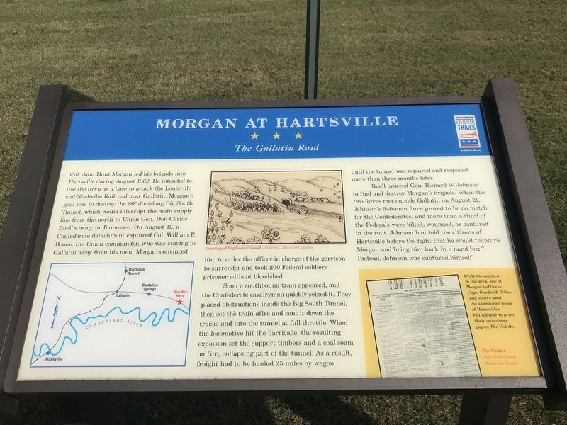
Morgan at Hartsville. The Gallatin Raid. Col. John Hunt Morgan led his brigade into Hartsville during August 1862. He intended to use the town as a base to attack the Louisville and Nashville Railroad near Gallatin. Morgan's goal was to destroy the 800-foot-long Big South Tunnel, which would interrupt the main supply line from the north to Union Gen. Don Carlos Buell's army in Tennessee. On August 12, a Confederate detachment captured Col. William P. Boone, the Union commander, who was staying in Gallatin away from his men. Morgan convinced him to order the officer in charge of the garrison to surrender and took 200 Federal soldiers prisoner without bloodshed., Soon a southbound train appeared, and the Confederate cavalrymen quickly seized it. They placed obstructions inside the Big South Tunnel, then set the train afire and sent it down the tracks and into the tunnel at full throttle. When the locomotive hit the barricade, the resulting explosion set the support timbers and a coal seam on fire, collapsing part of the tunnel. As a result, freight had to be hauled 25 miles by wagon until the tunnel was repaired and reopened more than three months later., Buell ordered Gen. Richard W. Johnson to find and destroy Morgan's brigade. When the two forces met outside Gallatin on August 21, Johnson's 640-man force proved to be no match for the Confederates, and more than a third of the Federals were killed, wounded, or captured in the rout. Johnson had told the citizens of Hartsville before the fight that he would “capture Morgan and bring him back in a band box.” Instead, Johnson was captured himself., Sidebar: , While bivouacked in the area, one of Morgan's officers, Capt. Gordon E. Niles, and others used the abandoned press of Hartsville's Plaindealer to print their own camp paper, The Vidette., Captions: , Center: Drawing of Big South Tunnel – Courtesy Library of Congress , Right: The Vidette , Trousdale County Historical Society
Col. John Hunt Morgan led his brigade into Hartsville during August 1862. He intended to use the town as a base to attack the Louisville and Nashville Railroad near Gallatin. Morgan's goal was to destroy the 800-foot-long Big South Tunnel, which would interrupt the main supply line from the north to Union Gen. Don Carlos Buell's army in Tennessee. On August 12, a Confederate detachment captured Col. William P. Boone, the Union commander, who was staying in Gallatin away from his men. Morgan convinced him to order the officer in charge of the garrison to surrender and took 200 Federal soldiers prisoner without bloodshed.
Soon a southbound train appeared, and the Confederate cavalrymen quickly seized it. They placed obstructions inside the Big South Tunnel, then set the train afire and sent it down the tracks and into the tunnel at full throttle. When the locomotive hit the barricade, the resulting explosion set the support timbers and a coal seam on fire, collapsing part of the tunnel. As a result, freight had to be hauled 25 miles by wagon until the tunnel was repaired and reopened more than three months later.
Buell
Click or scan to see this page online
ordered Gen. Richard W. Johnson to find and destroy Morgan's brigade. When the two forces met outside Gallatin on August 21, Johnson's 640-man force proved to be no match for the Confederates, and more than a third of the Federals were killed, wounded, or captured in the rout. Johnson had told the citizens of Hartsville before the fight that he would “capture Morgan and bring him back in a band box.” Instead, Johnson was captured himself.
Sidebar:
While bivouacked in the area, one of Morgan's officers, Capt. Gordon E. Niles, and others used the abandoned press of Hartsville's Plaindealer to print their own camp paper, The Vidette.
Captions: Center: Drawing of Big South Tunnel – Courtesy Library of Congress Right: The Vidette — Trousdale County Historical Society
Erected by Tennessee Civil War Trails.
Topics and series. This historical marker is listed in these topic lists: Railroads & Streetcars • War, US Civil. In addition, it is included in the Tennessee Civil War Trails series list. A significant historical date for this entry is August 12, 1862.
Location. 36° 23.955′ N, 86° 9.696′ W. Marker is in Hartsville,
Photographed by Duane and Tracy Marsteller, October 4, 2020
2. Morgan at Hartsville Marker
Tennessee, in Trousdale County. It is on McMurry Boulevard (State Highway 10) west of Hayes Street, on the right when traveling west. Touch for map. Marker is at or near this postal address: 114 McMurry Boulevard, Hartsville TN 37074, United States of America. Touch for directions.
Regionally, this marker is in Middle Tennessee and in the Highland Rim. It is also in the American South and specifically in the Upper South. Globally, it is in North America, the Western Hemisphere, the Western World, and the Anglosphere. Historically, it finds itself in what was once the territory of the Mississippian Culture, one of the Confederate States of America, and the Antebellum South.
Credits. This page was last revised on October 5, 2020. It was originally submitted on October 5, 2020, by Duane and Tracy Marsteller of Murfreesboro, Tennessee. This page has been viewed 665 times since then and 38 times this year. Photos:1, 2. submitted on October 5, 2020, by Duane and Tracy Marsteller of Murfreesboro, Tennessee. • Bernard Fisher was the editor who published this page.