Johnson City in Washington County, Tennessee — The American South (East South Central)
Main Street
Photographed by Duane and Tracy Marsteller, October 10, 2020
1. Main Street Marker
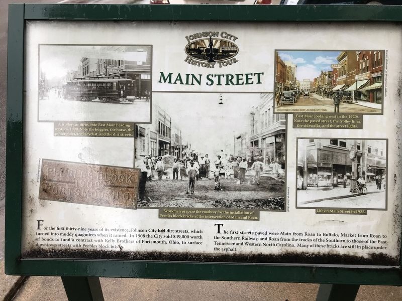
For the first thirty-nine years of its existence, Johnson City had dirt streets, which turned into muddy quagmires when it rained. In 1908 the City sold $49,000 worth of bonds to fund a contract with Kelly Brothers of Portsmouth, Ohio, to surface downtown streets with Peebles block bricks.
The first streets paved were Main from Roan to Buffalo, Market from Roan to the Southern Railway, and Roan from the tracks of the Southern to those of the East Tennessee and Western North Carolina. Many of these bricks are still in place under the asphalt.
Captions
Top left: A trolley car turns onto East Main heading west, ca. 1900. Note the buggies, the horse, the power poles, the bicyclist, and the dirt streets.
Top right: East Main looking west in the 1920s. Note the paved street, the trolley lines, the sidewalks, and the street lights.
Bottom right: Life on Main Street in 1922.
Center: Workmen prepare the roadway for the installation of Peebles block bricks at the intersection of Main and Roan.
Erected by Johnson City History Tour.
Topics. This historical marker is listed in this topic list: Roads & Vehicles. A significant historical year for this entry is 1908.
Location. 36° 18.993′ N,
this page online

Regionally, this marker is in East Tennessee and in the Tri-Cities Area. It is also in the American South, specifically in the Upper South, in Appalachia, and specifically in Southern Appalachia. Globally, it is in North America, the Western Hemisphere, the Western World, and the Anglosphere. Historically, it finds itself in what was once the original Cherokee Nation, the territory of the Mississippian Culture, one of the Confederate States of America, the State of Franklin, and the Antebellum South.
Other nearby markers. At least 8 other markers are within walking distance of this marker: James Hobart Stanton (about 400 feet away, measured in a direct line); Rich-R-Tone Records (about 400 feet away); Johnson City (about 500 feet away); John Sevier Hotel (about 600 feet away); Samuel Cole Williams
Photographed by Duane and Tracy Marsteller, October 10, 2020
2. Main Street Marker
Photographed by Tom Bosse, March 4, 2023
3. Main Street Marker
Credits. This page was last revised on March 22, 2023. It was originally submitted on October 13, 2020, by Duane and Tracy Marsteller of Murfreesboro, Tennessee. This page has been viewed 961 times since then and 55 times this year. Photos: 1, 2. submitted on October 13, 2020, by Duane and Tracy Marsteller of Murfreesboro, Tennessee. 3. submitted on March 22, 2023, by Tom Bosse of Jefferson City, Tennessee. • J. Makali Bruton was the editor who published this page.
