South Coventry in Tolland County, Connecticut — The American Northeast (New England)
John Boynton’s Mill
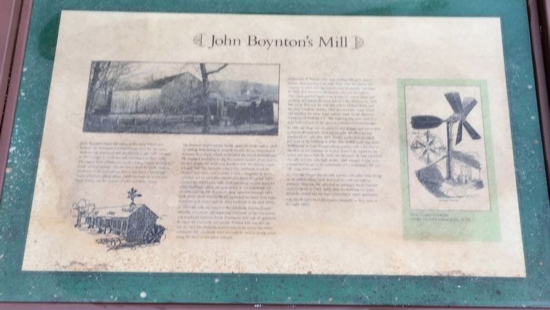
John Boynton began his career in the early 1800s and became the dominant businessman in town for the next 45 years. He purchased this site known as the ‘still’ lot and in 1815 at age 35, built the mill building seen here today.
The upper floor contained a wool carding engine serving the needs of local families. On the lower floor he made carding machines of his own patent. Power was from a breast-type water wheel providing about 14HP. He built his home just west of here, on the corner of Lake and Main Street.
Mr. Boynton improved the brook upstream of the mill in 1825 by adding stone lining to prevent erosion. To accommodate a fourteen foot water wheel, he lowered the brook downstream. He engaged workmen to dig the natural channel about four to six feet deeper for about 100 feet. He thereby created a larger “fall’ for the water wheel. The workmen lined the channel with stone and covered it with magnificent stone arch that can be seen downstream just above the pond. They covered the whole area with earth providing usable space for other buildings, which are gone today. It is a remarkable bit of workmanship. Mr. Boynton’s shop operated through 1854 with about thirty-five hands. He provided the town with loans, donations and advice until he went bankrupt in the mid 1850’s. In 1855 the mill was leased to the nationally famous Daniel Halladay who made self-regulating windmills of his own patent and employed eighteen hands. During his first year of operation he made 65 windmills and pumps. A brick kiln was also on site. In 1863 Mr. Halladay moved west to be nearer his many customers. His windmills were successfully used to pump water along the lines of our great railroads.
Crittenden & Tibbals, who were renting mill space down stream, then purchased the mill. They were the first in the country to enter into the manufacture of metallic cartridges. In 1866 they moved to Bridgeport and sold the mill to Dan Clark and Ed Taylor. They produced cotton twin and wicking and rented the brick kiln to a Mr. Holman. In 1875, Mr. Clark died and the mill was sold to Nathan White and his sister Charlotte Stanley. They removed the water wheel and installed the latest water turbine made by Bradway Company of Stafford, CT. The building was converted to a grist mill and part of the space rented to a wheelwright.
In 1881 the shop was occupied by D.F. Knight and was rented to Ernest Woodworth, both blacksmiths. Mr. Woodworth purchased the mill after 1900. Trolley tracks were installed just west of the building in 1909. The Trolley route was from Willimantic to Lake Wamgumbaug passing only a few feet to the west of the building on its way across Lake Street to the casino and dance hall. By 1920, Mr. Woodworth had converted the mill to make very high quality cider vinegar. A few of his vinegar bottles are in the possession of local residents. He was still using water power.
In 1945 Mr. Ernest Woodworth and his wife, who were living in the mill building, both died and the mill was sold to Anthony Tremont. He operated an appliance repair business until his death in 1984. Since then the building has been privately owned and has been converted to rental apartments. The brook and wheel pit remain essentially as they were in the early 1800’s.
Topics. This historical marker is listed in these topic lists: Agriculture • Industry & Commerce.
Location. 41° 46.161′ N, 72° 18.343′ W. Marker is in Coventry, Connecticut, in Tolland County. It is in South Coventry. Marker is at the intersection of Lake Street and Woodland Road, on the right when traveling north on Lake Street. Touch for map. Marker is in this post office area: Coventry CT 06238, United States of America. Touch for directions.
Other nearby markers. At least 8 other markers are within walking distance of this marker. Lakeside Park (a few steps from this marker); Warfield Pond (about 400 feet away, measured in a direct line); South Coventry Village (about 500 feet away); Veterans 1861-1865 (about 500 feet away); Captain Nathan Hale Monument (about 600 feet away); Nathan Hale Cemetery (about 600 feet away); Thomas H. Wood’s Silk Mill (about 600 feet away); E.A. Tracy Wool Extract and Shoddy Mill (approx. 0.2 miles away). Touch for a list and map of all markers in Coventry.
Credits. This page was last revised on February 10, 2023. It was originally submitted on October 26, 2020, by Brandon D Cross of Flagler Beach, Florida. This page has been viewed 229 times since then and 12 times this year. Photos: 1, 2. submitted on October 26, 2020, by Brandon D Cross of Flagler Beach, Florida. • Michael Herrick was the editor who published this page.

