Near Richmond in Chesterfield County, Virginia — The American South (Mid-Atlantic)
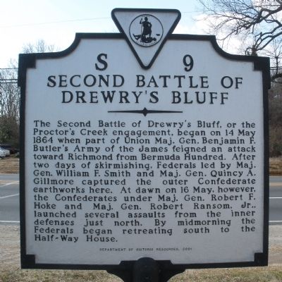
Second Battle of Drewry's Bluff
Erected 2001 by Department of Historic Resources. (Marker Number S-9.)
Topics and series. This historical marker is listed in this topic list: War, US Civil. In addition, it is included in the Virginia Department of Historic Resources (DHR) series list. A significant historical date for this entry is May 14, 1864.
Location. 37° 23.798′ N, 77° 25.826′ W. Marker is near Richmond, Virginia, in Chesterfield County. Marker is on Jefferson Davis Highway (U.S. 1) 0.2 miles north of Galena Avenue, on the right when traveling north. The marker is located in between the White House Motel and the Snow White Motel. Touch for map. Marker is in this post office area: Richmond VA 23237, United States of America. Touch for directions.
Other nearby markers. At least 8 other markers are within walking distance of this marker. Drewry’s Bluff Battlefield (a few steps from this marker); Fort Stevens (approx. half a mile away); First Virginia Infantry Regiment (approx. half a mile away); The Bermuda Campaign (approx. half a mile away); a different marker also named Fort Stevens (approx. half a mile away); Battle of Drewry’s Bluff (approx. 0.6 miles away); Drewry’s Bluff Defences (approx. 0.6 miles away); a different marker also named Second Battle of Drewry's Bluff (approx. ¾ mile away). Touch for a list and map of all markers in Richmond.
Also see . . . CWSAC Battle Summary. Proctor’s Creek (Submitted on February 10, 2009, by Bernard Fisher of Richmond, Virginia.)
Credits. This page was last revised on June 16, 2016. It was originally submitted on February 10, 2009, by Bernard Fisher of Richmond, Virginia. This page has been viewed 2,399 times since then and 71 times this year. Photos: 1, 2. submitted on February 10, 2009, by Bernard Fisher of Richmond, Virginia. • Craig Swain was the editor who published this page.

