Cumberland Township near Gettysburg in Adams County, Pennsylvania — The American Northeast (Mid-Atlantic)
Pettigrew and Trimble's Attack
July 3, 1863 - Third Day
"On and on they move, the Yankee lines pouring in their fire at every stop, men falling on every side."
Pvt. William F. Fulton, C.S.A.
5th Alabama Battalion, Pettigrew's Division
The bloody Confederate attack here on July 3 has come to be known as "Pickett's Charge." However, Pickett's Division was not alone. More than half the 12,000 Confederates engaged were from divisions commanded by Brig. Gen. James J. Pettigrew and Maj. Gen. Isaac R. Trimble. These troops formed their line of battle on Pickett's left (your right), and attacked at the same time.
About 3:00 p.m., the long line of men in gray and butternut stepped out of the woods in front of you and began their fatal march. An officer in Pettigrew's command recalled, "When within about 250 or 300 yards of the stone wall behind which the enemy was posted, we were met with a perfect hail-storm of lead.... Regiments that went in with colonels came out commanded by lieutenants."
A Union corporal here observed that the Rebels who began their attack with "a splendid appearance," soon "fell like grain before the reaper.... All that came as far as our line of battle came as prisoners, and out of 18 stand of colors they so nobly brought out, only one was seen to go back, 3,000 of their men were taken prisoner...."
Erected by Gettysburg National Military Park.
Topics. This historical marker is listed in this topic list: War, US Civil. A significant historical date for this entry is July 3, 1863.
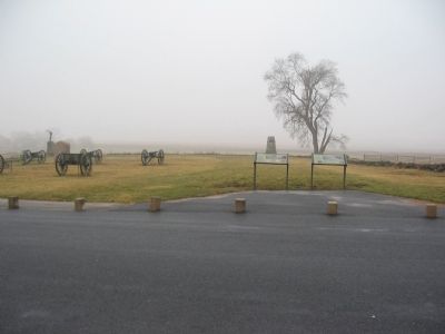
Location. This marker has been replaced by another marker nearby. It was located near 39° 48.8′ N, 77° 14.131′ W. Marker was near Gettysburg, Pennsylvania, in Adams County. It was in Cumberland Township. Marker was on Hancock Avenue, on the left when traveling north. Located in front of "the Angle" on Cemetery Ridge in Gettysburg National Military Park. Touch for map. Marker was in this post office area: Gettysburg PA 17325, United States of America. Touch for directions.
Other nearby markers. At least 8 other markers are within walking distance of this location. The Aftermath (here, next to this marker); Defining Moments (here, next to this marker); Gettysburg Cyclorama (a few steps from this marker); Artillery Brigade (a few steps from this marker); Army of the Potomac (a few steps from this marker); Arnold's Battery (a few steps from this marker); Twenty-Sixth North Carolina Regiment (within shouting distance of this marker); Lt. Alonzo Cushing (within shouting distance of this marker). Touch for a list and map of all markers in Gettysburg.
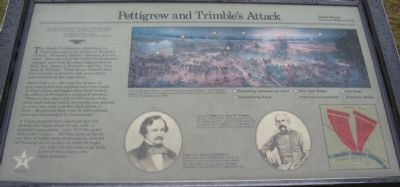
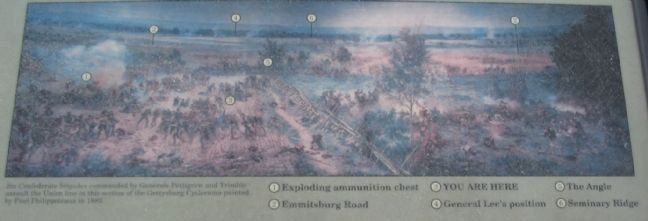
More about this marker. In the upper center is a section of the cyclorama painting: Six Confederate brigades commanded by Generals Pettigrew and Trimble assaulted the Union line in this section of the Gettysburg Cyclorama painted by Paul Philippoteaux in 1883. Key points indicated on the painting are:
(1) Exploding ammunition chest
(2) Emmitsburg Road
(3) You are here
(4) General Lee's position
(5) The Angle
(6) Seminary Ridge
In the lower center is a portrait of Brig. Gen. James J. Pettigrew who commanded the Confederate first line of attack, and was wounded in the hand. Ten days later, on the retreat through Maryland, he was killed by Federal cavalry.
Also in the lower center is a portrait of Maj. Gen. Isaac R. Trimble captioned: At age 61, Maj. Gen. Isaac R. Trimble was one of the oldest officers in Lee's army. He commanded the second line of attack 100 yards behind Pettigrew's men. Wounded in the leg, he was captured at a field hospital.
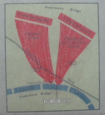
To the lower right is a map showing the advance of Pettigrew and Trimble's commands.
Related marker. Click here for another marker that is related to this marker. New Marker At This Location titled "The Aftermath".
Credits. This page was last revised on February 7, 2023. It was originally submitted on February 12, 2009, by Craig Swain of Leesburg, Virginia. This page has been viewed 1,247 times since then and 18 times this year. Photos: 1. submitted on February 12, 2009, by Craig Swain of Leesburg, Virginia. 2, 3. submitted on February 13, 2009, by Craig Swain of Leesburg, Virginia. 4. submitted on February 12, 2009, by Craig Swain of Leesburg, Virginia.


