AuSable in Clinton County, New York — The American Northeast (Mid-Atlantic)
What Is This Boat?
— What Was This Boat Used For? —
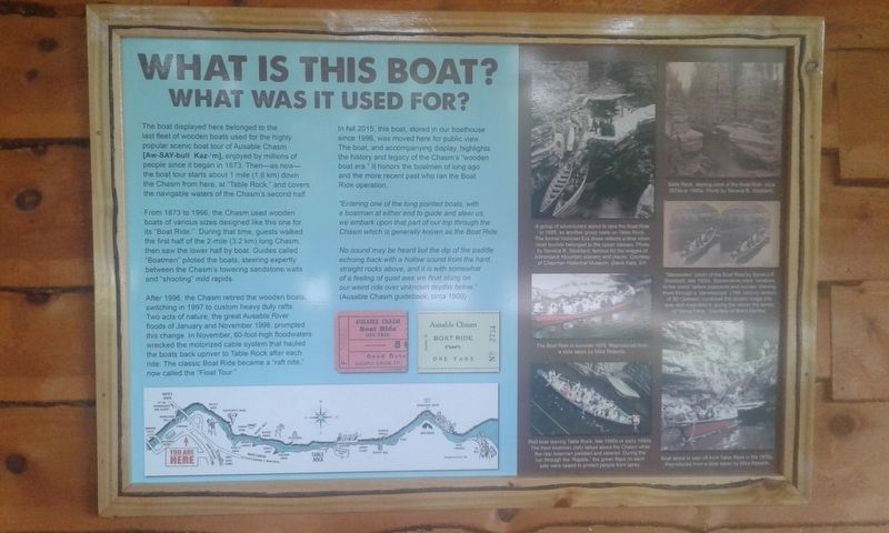
The boat displayed here belonged to the last fleet of wooden boats used for the highly popular scenic boat tour of Ausable Chasm [Aw-SAY-bull Kaz-'m], enjoyed by millions of people since it began in 1873. Then—as now—the boat tour starts about 1 mile (1.6 km) down the Chasm from here, at "Table Rock, ” and covers the navigable waters of the Chasm's second half.
From 1873 to 1996, the Chasm used wooden boats of various sizes designed like this one for its "Boat Ride.” During that time, guests walked the first half of the 2-mile (3.2 km) long Chasm, then saw the lower half by boat. Guides called "Boatmen” piloted the boats, steering expertly between the Chasm's towering sandstone walls and "shooting” mild rapids.
After 1996, the Chasm retired the wooden boats, switching in 1997 to custom heavy duty rafts. Two acts of nature, the great Ausable River floods of January and November 1996, prompted this change. In November, 60-foot-high floodwaters wrecked the motorized cable system that hauled the boats back upriver to Table Rock after each ride. The classic Boat Ride became a "raft ride," now called the "Float Tour."
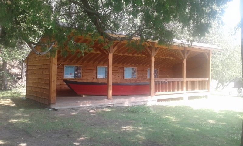
In fall 2015, this boat, stored in our boathouse since 1996, was moved here for public view. The boat, and accompanying display, highlights the history and legacy of the Chasm's "wooden boat era.” It honors the boatmen of long ago and the more recent past who ran the Boat Ride operation.
"Entering one of the long pointed boats, with a boatman at either end to guide and steer us, we embark upon that part of our trip through the Chasm which is generally known as the Boat Ride.
No sound may be heard but the dip of the paddle echoing back with a hollow sound from the hard, straight rocks above, and it is with somewhat of a feeling of quiet awe we float along on our weird ride over unknown depths below."
(Ausable Chasm guidebook, circa 1900)
Topics. This historical marker is listed in these topic lists: Parks & Recreational Areas • Waterways & Vessels. A significant historical month for this entry is November 1996.
Location. 44° 31.503′ N, 73° 27.708′ W. Marker is in AuSable, New York, in Clinton County. Marker is on Mace Chasm Road near U.S. 9, on the left when traveling west. Located behind the entrance to Ausable Chasm. Touch for map. Marker is in this post office area: Keeseville NY 12911, United States of America. Touch for directions.
Other nearby markers. At least 8 other markers are within 2 miles of this marker, measured as the crow flies. Ausable Chasm's "Famous Boat Ride" (here, next to this marker); The Boats And The Boatmen (here, next to this marker); How Did They Get Boats Back For The Next Ride? (a few steps from this marker); Herbert Estes (within shouting distance of this marker); Our Freedom Bell (within shouting distance of this marker); Rainbow Falls Hydroelectric Plant (about 600 feet away, measured in a direct line); Train Depot (approx. 1.4 miles away); Mineral Spring (approx. 1.6 miles away). Touch for a list and map of all markers in AuSable.
Also see . . .
1. Ausable Chasm. (Submitted on November 28, 2020, by Michael Herrick of Southbury, Connecticut.)
2. Ausable Chasm (Wikipedia). (Submitted on November 28, 2020, by Michael Herrick of Southbury, Connecticut.)
Credits. This page was last revised on November 28, 2020. It was originally submitted on November 23, 2020, by Craig Doda of Napoleon, Ohio. This page has been viewed 173 times since then and 12 times this year. Photos: 1, 2, 3. submitted on November 23, 2020, by Craig Doda of Napoleon, Ohio. • Michael Herrick was the editor who published this page.


