Breaks in Dickenson County, Virginia — The American South (Mid-Atlantic)
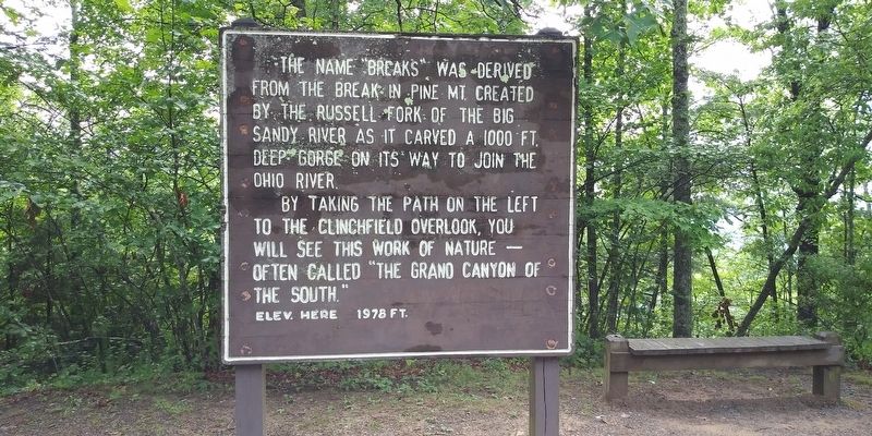
The Name Breaks
By taking the path on the left to the Clinchfield Overlook, you will see this work of nature often called "The Grand Canyon of the South." Elev. here 1978 ft.
Topics. This historical marker is listed in these topic lists: Natural Features • Parks & Recreational Areas.
Location. 37° 17.183′ N, 82° 18.183′ W. Marker is in Breaks, Virginia, in Dickenson County. Marker is on Breaks Park Road. Touch for map. Marker is in this post office area: Breaks VA 24607, United States of America. Touch for directions.
Other nearby markers. At least 8 other markers are within walking distance of this marker. Clinchfield Overlook (about 500 feet away, measured in a direct line); Salt Kettle (approx. 0.4 miles away); Early Settlement (approx. 0.4 miles away); Formation Of The Breaks (approx. 0.6 miles away); Mill Rock Point (approx. 0.8 miles away); Mill Rock Point Overlook (approx. 0.8 miles away); The Crooked Road (approx. 0.8 miles away); Known But to God (approx. one mile away in Kentucky). Touch for a list and map of all markers in Breaks.
Credits. This page was last revised on December 6, 2020. It was originally submitted on November 26, 2020, by Craig Doda of Napoleon, Ohio. This page has been viewed 162 times since then and 18 times this year. Photos: 1, 2. submitted on November 26, 2020, by Craig Doda of Napoleon, Ohio. • Bill Pfingsten was the editor who published this page.

