Ortonville in Big Stone County, Minnesota — The American Midwest (Upper Plains)
A Glacial Wall of Water
The Glacial River Warren
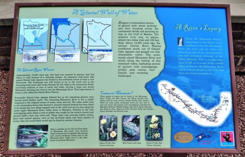
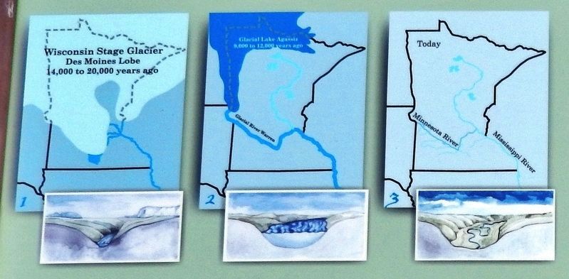
Approximately 13,000 years ago, this land was encased by glaciers that had begun to melt because of a warming climate. An expansive melt-water lake named Glacial Lake Agassiz was formed in the northwest corner of what is now Minnesota. The landscape was still frozen in ice to the north and so the deepening melt-water lake broke through the low ridge at the continental divide, excavating millions of tons of earth and rocks, carving a large scar across Minnesota, draining into what is now the Mississippi River. That huge torrent of water is now called the Glacial River Warren.
Eventually Glacial Lake Agassiz drained dry as the remaining glaciers were located much farther north. The remaining Minnesota River is but a trickle compared to the original torrent of water, rocks and soil. The valley holds clues to the tremendous forces that formed it. Ancient exposed bedrock has been dated to be among the very oldest exposed rock in the world and can be seen along the entire upper Minnesota River Valley down to Mankato. Potholes in the rock outcroppings show where a rock or pebble was caught by the water's current and ground itself a hole into solid rock. These same rock outcrops harbor unique plant and animal species, such as the five-lined skink and three species of cactus, that one would think would only be found in warmer climates.
A River’s Legacy
From the Minnesota River's beginnings in the plains to its confluence into the Mississippi River, the river and its valley tell interesting tales of the ancient history and rich ecological diversity of the Upper Midwest. This is an important story to tell, as it is part of the overall effort to restore the Minnesota River and to connect people to the river and their own local environment.
Erected by Big Stone County Historical Society, and Federal Highway Administration.
Topics. This historical marker is listed in these topic lists: Animals • Environment • Waterways & Vessels.
Location. 45° 17.817′ N, 96° 25.952′ W. Marker is in Ortonville, Minnesota, in Big Stone County. Marker can be reached from U.S. 12, 0.1 miles west of U.S. 75, on the left when traveling west. Marker is located at the Big Stone County Welcome Center. Touch for map. Marker is at or near this postal address: 985 US Highway 12, Ortonville MN 56278, United States of America. Touch for directions.
Other nearby markers. At least 8 other markers are within 11 miles of this marker, measured as the crow flies. Geology of Minnesota (a few steps from this marker); Paul Bunyan's Boat-Anchor (a few steps from this marker); Big Stone County Courthouse (approx. 0.8 miles away); Ancient Exposed Rock (approx. 3.2 miles away); Welcome to Odessa (approx. 5˝ miles away); St. Pauli Lutheran Church (approx. 9 miles away); Grant County Veterans Memorial (approx. 10.7 miles away in South Dakota); American Legion Junior Baseball Monument (approx. 10.8 miles away in South Dakota). Touch for a list and map of all markers in Ortonville.
Also see . . .
1. Lake Agassiz (Wikipedia). Lake Agassiz was a very large glacial lake in central North America. Fed by glacial meltwater at the end of the last glacial period, its area was larger than all of the modern Great Lakes combined though its mean depth was not as great as that of many major lakes today. (Submitted on November 29, 2020, by Cosmos Mariner of Cape Canaveral, Florida.)
2. Glacial River Warren (Wikipedia). Glacial River Warren,

Photographed By John J. Mosesso, NBII
3. Marker detail: Five-lined Skink
Keep a watchful eye for the five-lined skink. In Minnesota, this small, rare, secretive lizard is found only on exposed rock outcrops with nearby deciduous forests here in the Minnesota River Valley and in a few other places in southeast Minnesota.

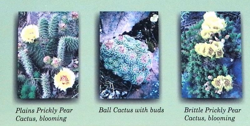
4. Marker detail: Cactus in Minnesota?
Three species of cactus can be found in the Minnesota River Valley: the Ball Cactus, the Plains Prickly Pear Cactus and the most common Brittle Prickly Pear Cactus. There are many public landscapes where you may visit to view the cactus and ancient rock outcroppings including the Big Stone National Wildlife Refuge, Blue Devil Valley Scientific and Natural Area, Memorial Park (Granite Falls) and Swede's Forest Scientific and Natural Area.
• Plains Prickly Pear Cactus, blooming
• Ball Cactus with buds
• Brittle Prickly Pear Cactus, blooming
• Plains Prickly Pear Cactus, blooming
• Ball Cactus with buds
• Brittle Prickly Pear Cactus, blooming
Credits. This page was last revised on November 29, 2020. It was originally submitted on November 27, 2020, by Cosmos Mariner of Cape Canaveral, Florida. This page has been viewed 570 times since then and 30 times this year. Photos: 1, 2, 3, 4, 5. submitted on November 29, 2020, by Cosmos Mariner of Cape Canaveral, Florida.


