Hyannis in Barnstable County, Massachusetts — The American Northeast (New England)
Hyannis Main Street
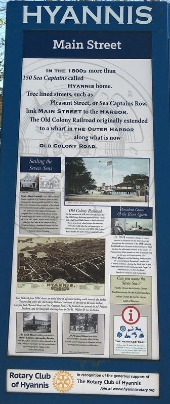
In the 1800s more than 150 Sea Captains called Hyannis home. Tree lined streets, such as Pleasant Street, or Sea Captain Row, link Main Street to the Harbor. The Old Colony Railroad originally extended to a wharf in The Outer Harbor along what is now Old Colony Road.
Sailing the Seven Seas
Capt. Allen Crowell (1821-1891), whose home was built at 35 Pleasant Street in 1852, is famous for having sailed the Seven Seas. His home remains a fine example of the Greek Revival architectural tradition popular in that era and found throughout the historic neighborhood of Pleasant & School Streets. Crowell began his career on the sea at the age of 10. In 1847, with captain Alan Baxter, he sailed on the Cabot & the American Belle, bringing grain to a famished Ireland. On his return, Baxter set the record of that era for an Atlantic Ocean crossing.
Old Colony Railroad
In the summer of 1854, the railroad tracks for the Old Colony Railroad were extended a mile and a half from Main Street to South Hyannis shore, to a stone wharf where the steamer Nebraska could take the rail passengers to Nantucket. The rail ran until 1872. Old Colony Road marks the path of these original tracks.
President Grant & the River Queen
in 1874 President Ulysses S. Grant arrived in Hyannis on the River Queen to inaugurate the extension of the Old Colony Railroad from Hyannis to Provincetown. With fanfare, he addressed crowds at the corner of Pleasant and Main Streets, as well as at each stop on his way to Provincetown. The River Queen was the floating headquarters for General Grant, President Lincoln and General Sherman during the Civil War. It was later operated by the Nantucket and Cape Cod Steamboat Co. in New Bedford, Martha’s Vineyard and Nantucket.
Can you name the Seven Seas?
Pacific Ocean • Atlantic Ocean • Mediterranean Sea • Caribbean Sea • Indian Ocean • Arctic Ocean • Gulf of Mexico
Captions
This postcard from 1884 shows an aerial view of Hyannis looking south towards the harbor. Can you find where the Old Colony Railroad continued all the way to the outer harbor? Can you find Pleasant Street and Sea Captains Row? The postcard was printed by AF Poole in Brockton, and the lithograph drawing done by Geo H. Walker & Co. in Boston.
The Cash Block building was built in 1829 by Captain Alexander Baxter, with F.C. Tobey. Baxter is often referred to as “the Father of Hyannis,” for his commitment to developing the village in the early 19th century.
27 Pleasant Street was built before 1770 by Captain Allen Hallett. It is the oldest residence in Hyannis still on its original foundation and location. Photos courtesy of Hyannis Public Library
Erected by Rotary Club of Hyannis.
Topics and series. This historical marker is listed in these topic lists: Industry & Commerce • Railroads & Streetcars • Waterways & Vessels. In addition, it is included in the Rotary International series list.
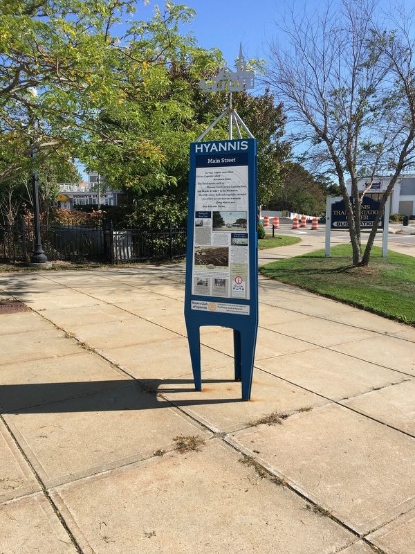
Location. 41° 39.296′ N, 70° 16.826′ W. Marker is in Hyannis, Massachusetts, in Barnstable County. Marker is at the intersection of Main Street and Center Street, on the left when traveling south on Main Street. Touch for map. Marker is in this post office area: Hyannis MA 02601, United States of America. Touch for directions.
Other nearby markers. At least 8 other markers are within walking distance of this marker. The Federated Church of Hyannis (about 500 feet away, measured in a direct line); Hyannis Ocean Street (about 800 feet away); Battle Of The Bulge (approx. 0.2 miles away); Hyannis Normal School (approx. 0.2 miles away); Kevin Arthur Houston (approx. 0.2 miles away); Vietnam Veterans Memorial (approx. ¼ mile away); SGT. Mark Vecchione Memorial (approx. ¼ mile away); National Seashore (approx. ¼ mile away). Touch for a list and map of all markers in Hyannis.
Credits. This page was last revised on December 15, 2020. It was originally submitted on December 15, 2020, by Brandon D Cross of Flagler Beach, Florida. This page has been viewed 208 times since then and 11 times this year. Photos: 1, 2. submitted on December 15, 2020, by Brandon D Cross of Flagler Beach, Florida. • J. Makali Bruton was the editor who published this page.

