Near Jamestown in Stutsman County, North Dakota — The American Midwest (Upper Plains)
North Dakota Native Prairies
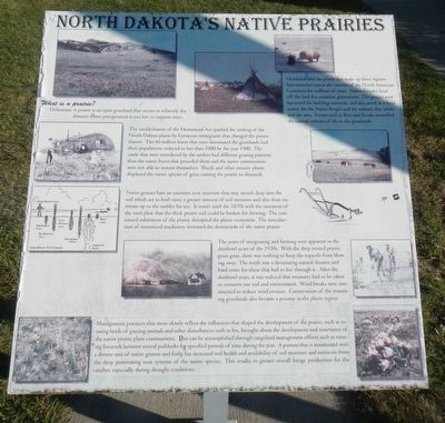
What is a Prairie?
Definition: A prairie is an open grassland that occurs in relatively dry climates where precipitation is too low to support trees.
Grasslands and the plants that make up there regions have stretched across the interior of the North American Continent for millions of years. Native Peoples lived off the land for countless generations. The grasses were harvested for building materials, and also acted as a food source for the Native People and the animals that inhabited the area. Events such as fires and floods controlled the natural systems of life in the grasslands.
The establishment of the Homestead Act sparked the settling of the North Dakota plains by European immigrants that changed the prairies forever. The 60 million bison that once dominated the grasslands had their populations reduced to less than 1000 by the year 1900. The cattle that were introduced by the settlers had different grazing patterns than the native bison that preceded them and the native communities were not able to sustain themselves. Weeds and other invasive plants displaced the native species of grass causing the prairie to diminish.
Native grasses have an extensive root structure that may stretch deep into the soil which act to both store a greater amount of soil moisture and also draw nutrients up to the surface for use. In wasn't until the 1870s with the invention of the steel plow that the thick prairie sod could be broken for farming. The continued cultivation the prairie disrupted the plains ecosystem. The introduction of motorized machinery increased the destruction of the naive prairie.
The years of overgrazing and farming were apparent in the dustbowl years of 1930s. With the deep rooted prairie grass gone, there was nothing to keep the topsoils from blowing away. The result was a devastating natural disaster and hard times for those that has to live through it. After the dustbowl years, it was realized that measures had to be taken to conserve our soil and environment. Wind breaks were constructed to reduce wind erosion. Conservation of the remaining grasslands also became a priority in the plains region.
Management practices that most closely reflect the influences that shaped the development of the prairie, such as rotating herds of grazing animals and other disturbances such as fire, brought about the development and sustenance of the naive prairie plant communities. This can be accomplished through rangeland management efforts such as rotating livestock between serval paddocks for specified periods of time during the year. A pasture that is maintained with a diverse mix of native grasses and forms has increased soil heat and availability of soil moisture and nutrients from the deep penetrating root system of the native species. This results in greater overall forage production for the rancher, especially during drought conditions.
Erected by North Dakota Highway Department.
Topics. This historical marker is listed in this topic list: Natural Features.
Location. 46° 53.585′ N, 98° 48.265′ W. Marker is near Jamestown, North Dakota, in Stutsman County. Marker is on Interstate 94 at milepost 253,, 2.3 miles west of 81st Ave SE (Bypass U.S. 281), on the right when traveling west. The marker is in the Jamestown Rest Area Westbound. Touch for map. Marker is in this post office area: Jamestown ND 58401, United States of America. Touch for directions.
Other nearby markers. At least 8 other markers are within 5 miles of this marker, measured as the crow flies. Fort Seward (approx. 4.1 miles away); Fort William H. Seward (approx. 4.2 miles away); a different marker also named Fort Seward (approx. 4.2 miles away); Model 1861 8" Siege Howitzer (approx. 4.2 miles away); Alton Klaus (approx. 4.2 miles away); Where the Two Rivers Meet (approx. 4.2 miles away); The Hansen Arts Park (approx. 4.6 miles away); In Celebration of the Two Hundredth Year Birthday of the United States of America, 1976 (approx. 4.7 miles away). Touch for a list and map of all markers in Jamestown.
Credits. This page was last revised on December 22, 2020. It was originally submitted on December 20, 2020, by Barry Swackhamer of Brentwood, California. This page has been viewed 262 times since then and 35 times this year. Photos: 1, 2. submitted on December 20, 2020, by Barry Swackhamer of Brentwood, California.

