Fork Shoals in Greenville County, South Carolina — The American South (South Atlantic)
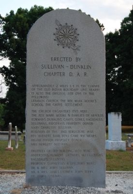
Erected by Sullivan - Dunklin Chapter D.A.R.
Inscription.
[Front]:
Approximately 2 miles s.e. is the corner of the Old Indian Boundary Line. Nearby is also the original site 1785 of the following:
Lebanon Church, the Rev. Mark Moore's School, the Grove Settlement.
The church organizers 1785 were: the Rev. Mark Moore & families of Arnolds, Bowmans, Dunklins, Camps, Gores, Ragsdales, Sullivan, Ridgeways. Property donor - Mary Charlton Sullivan.
Builders of the 2nd structure 1832: Rev. Barnett Babb, Benj. Camp, Wm. Mears, Abijah Pinson. Property donor - Mrs. Hewlitt Sullivan.
Trustees of 3rd building 1859 were: Anderson, Humbert, Latimers, McCulloughs, Ragsdales, Sullivans. Property conveyors & erectors were: Dr. & Mrs. John Sullivan, Mr. & Mrs. James Latimer, John Jerry, Dr. James Sullivan.
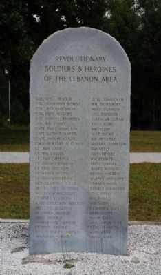
[Reverse]:
Col. Benj. Arnold, Col. Jonathan Downs, Col. Jhn. Brockman, Col. Benj. Kilgore, Col. Samuel Wharton, Col. Wm. Toney, Capt. Thos. Hamilton, Capt. George Martin, Capt. Jno. Ridgeway, Capt. Hewlet Sullivan, Lt. Jno. Camp, Lt. Wm. Choice, Lt. Jno. Calhoun, Lt. Joseph Dunklin, Lt. Oen Sullivan, Lt. James Sullivan, Sgt. Claiborn Sullivan, Sgt. Stephen Sullivan, Sgt. Peter Ragsdale, Charles Sullivan, Mary Charlton Sullivan, Pleasant Sullivan, Hendrick Arnold, Thos. Arnold, Temperance Arnold, Charity Adhold, Ann Hendrick Arnold, Elizabeth Harvey
[Right-Hand Column]:
Joel Chandler, Wm. Davenport, Mary Dunklin, Jno. Dunklin, Jeremiah Glenn, Thos. Gore, Wm. Terry, Jane Hicks, Wm. Holland, Martha Johnson, Wm. Kelly, Thos. Moore, Wm. Perritt, Thos. Lindley, James McDavid, Henry Machen, Martin Mahaffey, Edward Nash, George Mayberry, Jno. O'Dell, Wm. Powell, Wm. Shipp, Clayborn Sims, Robt. Scott, David Smith, Benj. Arnold, Sr., Samuel Bolling, Thos. Camp, Jerry Webb
Erected by Sullivan - Dunklin Chapter D.A.R.
Topics and series. This historical marker is listed in these topic lists: Churches & Religion • Colonial Era • Native Americans • Settlements & Settlers. In addition, it is included in the Daughters of the American Revolution series list. A significant historical year for this entry is 1785.
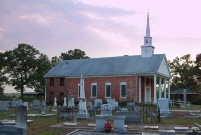
Location. 34° 33.7′ N, 82° 15.917′ W. Marker is in Fork Shoals, South Carolina, in Greenville County. Marker is on Dunklin Bridge Road, on the right when traveling west. Marker is located in the cemetery adjacent to Lebanon Church. Touch for map. Marker is at or near this postal address: 1450 Dunklin Bridge Road, Honea Path SC 29654, United States of America. Touch for directions.
Other nearby markers. At least 10 other markers are within 6 miles of this marker, measured as the crow flies. Lebanon Church (within shouting distance of this marker);
Sullivan (Grove) Cemetery (approx. 0.8 miles away); Tullyton (approx. 3.7 miles away); History - Cedar Falls Park (approx. 4 miles away); History – Cedar Falls Park (approx. 4 miles away); a different marker also named History - Cedar Falls Park (approx. 4 miles away); Environment – Cedar Falls Park (approx. 4 miles away); Fork Shoals School (approx. 4.9 miles away); Fork Shoals Baptist Church (approx. 4.9 miles away); Fairview Church / Fairview Cemetery (approx. 5.8 miles away). Touch for a list and map of all markers in Fork Shoals.
Additional commentary.
1. Rev. Mark Moore
Rev. Mark Moore taught at the Mount Bethel Academy, located in Newberry District and founded by Bishop Asbury from Virginia on March 20, 1795. Moore served at the school for six years. He was followed by Mr. Hammond, father of Governor James H. Hammond. During the late 1700s and early 1800s, Mount Bethel and Willington were the high grade schools this far inland. Mount Bethel closed its doors
in 1820. Many of its students now attended nearby Tabernacle Academy. In 1835, the Cokesbury School opened; many feel that Mount Ariel Academy was its germ. (Source: http://src1.cas.sc.edu/dept2/iss/SCNames/index.php?action=showPage&book=2&volume=17&page=42.)
— Submitted February 21, 2009, by Brian Scott of Anderson, South Carolina.
Credits. This page was last revised on June 16, 2016. It was originally submitted on February 21, 2009, by Brian Scott of Anderson, South Carolina. This page has been viewed 3,135 times since then and 98 times this year. Photos: 1. submitted on February 21, 2009, by Brian Scott of Anderson, South Carolina. 2. submitted on October 18, 2010, by Brian Scott of Anderson, South Carolina. 3, 4. submitted on February 21, 2009, by Brian Scott of Anderson, South Carolina.


