The Many Faces of the Trail
The bluffs have witnessed a wide variety of travelers.
— Scotts Bluff National Monument, National Park Service, U.S. Department of the Interior —
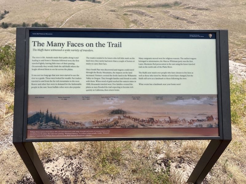
The river is life. Animals made their paths along it and leading to and from it. Humans followed next; the first traveled lightly, leaving little trace of their passing. Occasionally they would climb the tall bluffs where the height allowed them to see far across the plains.
It was not too long ago that new men started to use the river as a guide. These men looked for wealth. Fur traders traveled to and from the fur rich mountains to the west. Beaver and other furs were in demand for the fashionable people in the east. Soon buffalo robes were also popular.
The traders tended to be loners who left little mark on the land since they rarely had more than a couple of horses or mules to carry their furs.
Once South Pass was discovered and wagons could travel through the Rocky Mountains, the impacts on the land increased. Farmers coveted the fertile land in the Willamette Valley in Oregon. They brought families and friends to settle with them. When word of gold reached the eastern states in 1848, thousands traveled west. Few families crossed the plains as men flooded the trail expecting to become rich quickly in California, then return home.
Many emigrants moved west for religious reasons. The earliest wagons belonged to missionaries; the Marcus Whitman party was the first. Later, Mormons fled persecution in
the east using the lesser traveled trail on the north side of the Platte River.The bluffs now watch over people who have chosen to live here as well as those who travel by. Modes of travel have changed, but the bluffs still serve as a landmark to those following the river.
What events has a landmark near your home seen?
[Timeline:]
Wild Animals
Native Americans ??-1900
Fur Traders 1812-1850
Euro-American Emigrants 1836-1869
Pony Express 1860-1861
Stagecoach 1861-1869
Railroad 1869-Present
Automobile 1886-Present
Airplane 1914-Present
[Caption:]
William Henry Jackson lived almost 100 years and witnessed a wide range of people and modes of transportation as they
traveled across the plains. His watercolor painting, "Westward America,” is a tribute to those people.
Erected by National Park Service, U.S. Department of the Interior.
Topics. This historical marker is listed in these topic lists: Industry & Commerce • Native Americans • Roads & Vehicles • Settlements & Settlers. A significant historical year for this entry is 1848.
Location. 41° 50.089′ N, 103° 41.975′ W. Marker is in Gering, Nebraska, in Scotts Bluff County. Marker can be reached from
Other nearby markers. At least 8 other markers are within walking distance of this marker. Before the Wagons (here, next to this marker); A Landscape Changed Forever (a few steps from this marker); Remnant Highlands (within shouting distance of this marker); A Landmark for the Ages (approx. 0.2 miles away); Saddle Rock Trail (approx. 0.2 miles away); Eroding Landmark (approx. ¼ mile away); Scott Memorial (approx. ¼ mile away); The Way West (approx. 0.4 miles away). Touch for a list and map of all markers in Gering.
Credits. This page was last revised on January 5, 2021. It was originally submitted on January 4, 2021, by Connor Olson of Kewaskum, Wisconsin. This page has been viewed 151 times since then and 6 times this year. Photos: 1, 2. submitted on January 4, 2021, by Connor Olson of Kewaskum, Wisconsin. • Devry Becker Jones was the editor who published this page.

