Little Sandy in Elliott County, Kentucky — The American South (East South Central)
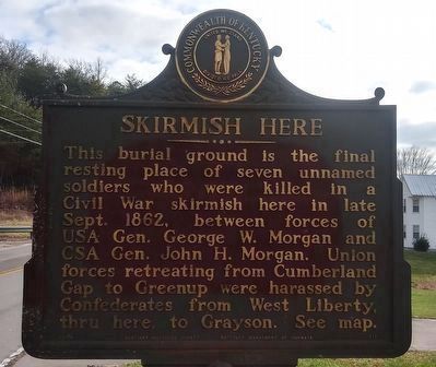
Skirmish Here
⎯⎯⎯
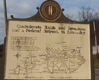
Confederate Raids and Invasions and a Federal Retreat, in Kentucky.
Photographed by Craig Doda, January 7, 2021
1. Skirmish Here / Confederate Raids and Invasions and a Federal Retreat, in Kentucky Marker
This burial ground is the final resting place of seven unnamed soldiers who were killed in a Civil War skirmish here in late Sept. 1862, between forces of USA Gen. George W. Morgan and CSA Gen. John H. Morgan. Union forces retreating from Cumberland Gap to Greenup were harassed by Confederates from West Liberty, thru here, to Grayson. See map.
— Lt. Gen. N. B. Forrest's Raid - Nov. 1881 - Feb. 1882
— Lt. Gen. N. B. Forrest's Raid - Dec. 1882
— Lt. Gen. N. B. Forrest's Raid - March - April 1884
— Lt. Gen. N. B. Forrest's Raid - Oct. - Nov. 1884
— Brig. Gen. John H. Morgan's Raid - July 1882
— Brig. Gen. John H. Morgan's Raid - Dec. 1882
— Brig. Gen. John H. Morgan's Raid - July 1883
— Brig. Gen. John H. Morgan's Raid - June 1884
— Gen. Braxton Bragg's Invasion - Aug. - Sept. 1882
— Maj. Gen. E. Kirby Smith's Invasion - Aug. - Sept. 1882
— Brigd. Gen. George W. Morgan's Retreat - Sept. - Oct. 1882
Erected 1964 by Kentucky Historical Society. (Marker Number 711.)
Topics. This historical marker is listed in this topic list: War, US Civil. A significant historical month for this entry is April 1884.
Location. 38° 4.119′ N, 83° 9.742′ W.
this page online

Regionally, this marker is in the Kyova Tri-State Region and in the Cumberland Plateau. It is also in the American South, specifically in the Upper South, in Appalachia, and specifically in Southern Appalachia. Globally, it is in North America, the Western Hemisphere, the Western World, and the Anglosphere. Historically, it finds itself in what was once the territory of the Mississippian Culture and also the Antebellum South.
Other nearby markers. At least 7 other markers are within 17 miles of this marker, measured as the crow flies: A Masterful Retreat / Confederate Raids and Invasions and a Federal Retreat, in Kentucky. (approx. 2.3 miles away); County Named, 1869 (approx. 2.4 miles away); Elliot County Veterans Memorial (approx. 3.4 miles away); Founding of Morgan County / The Old Mill (approx. 11.4 miles away); West Liberty - Civil War
Photographed by Craig Doda, January 7, 2021
2. Skirmish Here / Confederate Raids and Invasions and a Federal Retreat, in Kentucky Marker
Another marker is no longer nearby. County Named, 1822 (was approx. 11½ miles away but has been confirmed missing).
Photographed by Craig Doda, January 7, 2021
3. Skirmish Here / Confederate Raids and Invasions and a Federal Retreat, in Kentucky Marker
Credits. This page was last revised on November 9, 2024. It was originally submitted on January 9, 2021, by Craig Doda of Napoleon, Ohio. This page has been viewed 981 times since then and 85 times this year. Photos: 1, 2, 3. submitted on January 9, 2021, by Craig Doda of Napoleon, Ohio. • Bernard Fisher was the editor who published this page.
