Chester in Chesterfield County, Virginia — The American South (Mid-Atlantic)
USCTs At Dutch Gap
U.S. Colored Troops Construct the Canal
| — | Bermuda Hundred | — |
Photographed by Bernard Fisher, June 27, 2013
1. USCTs At Dutch Gap CWT Marker
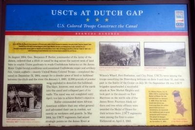
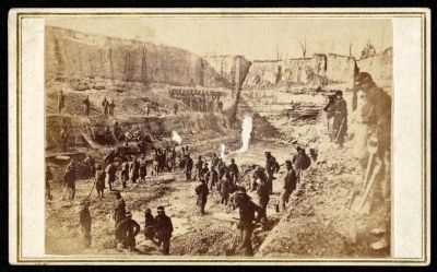
In August 1864, Gen. Benjamin F. Butler, commander of the Army of the James, ordered that a ditch or canal be dug across the narrow neck of land here to enable Union gunboats to evade Confederate batteries on the James River. Under brutal conditions and occasional Confederate sniper and artillery fire, Union soldiers—mostly United States Colored Troops—completed the canal on December 31, 1864, except for a slender piece of land or bulkhead between the ditch and the river. On January 1, 1865, 12,000 pounds of powder were
this page online
Butler commanded more African American soldiers than any other general and advocated their use in combat, not merely as workmen and guards. In May 1864, his USCT regiments had seized strategic points on the James River at Wilson’s Wharf, Fort Powhatan, and City Point. USCTs were among the troops assaulting the Petersburg defenses on June 9 and June 15, and took part in the Battle of the Crater on July 20. On September 29, two USCT brigades spearheaded a successful attack at New Market Heights and took part in the assault on Fort Harrison on the north side of the James River. Fourteen black soldiers and two white officers were awarded the Medal of Honor for their actions there. USCT regiments were among the first to enter Richmond on April 3, 1865.
(sidebar)
Lt. Walter Thorn, Co. G, 116th USCT, received the Medal of Honor for his actions here on January 1, 1865, when the bulk-head was blown up. Learning that the picket guard
November 1864
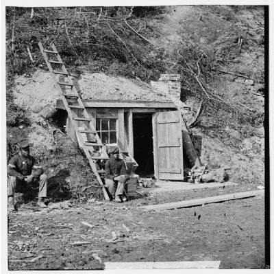
2. USCT picket post Dutch Gap Canal, November 1864
Dutch Gap, Va. Bomb-proof quarters of Major Strong
Library of Congress [LC-DIG-cwpb-01925]
Library of Congress [LC-DIG-cwpb-01925]
Erected by Virginia Civil War Trails.
Topics and series. This historical marker is listed in these topic lists: African Americans • War, US Civil. In addition, it is included in the Medal of Honor Recipients, and the Virginia Civil War Trails series lists. A significant historical month for this entry is May 1864.
Location. 37° 22.593′ N, 77° 21.617′ W. Marker is in Chester, Virginia, in Chesterfield County. It can be reached from Henricus Park Road 1.3 miles east of Coxendale Road. Located in Henricus Historical Park 300 yards north of the parking lot. Touch for map. Marker is at or near this postal address: 251 Henricus Park Road, Chester VA 23836, United States of America. Touch for directions.

Regionally, this marker is in Virginia’s Piedmont, in Central Virginia, and in the Richmond Metropolitan Area. It is also in the American South, specifically in the Upper South, and on the Eastern Seaboard. Globally, it is in the North
circa 1864
3. USCTs at work in the Dutch Gap Canal
Butler's Dutch Gap Canal, James River, Virginia
Library of Congress [LC-DIG-ppmsca-10894]
Library of Congress [LC-DIG-ppmsca-10894]
Other nearby markers. At least 8 other markers are within walking distance of this marker: Dutch Gap Canal (here, next to this marker); The Bermuda Hundred Campaign (here, next to this marker); Mortar Pit (a few steps from this marker); The Lightkeeper’s House (within shouting distance of this marker); Henricopolis (within shouting distance of this marker); The Church of Henricopolis (within shouting distance of this marker); Henricus Historical Park (within shouting distance of this marker); John Smith Explores the Chesapeake (within shouting distance of this marker). Touch for a list and map of all markers in Chester.
Other markers no longer nearby. The James River...Floating Through The Centuries (was a few steps from this marker but has been permanently removed); Dutch Gap (was a few steps from this marker but has been permanently
Photographed by John Reekie, April 1865
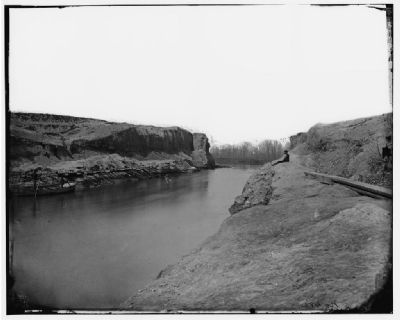
4. Completed canal, April 1865
Dutch Gap Canal, Virginia. View of completed canal
Library of Congress [LC-DIG-cwpb-03992]
Library of Congress [LC-DIG-cwpb-03992]
Also see . . . Henricus Historical Park. (Submitted on June 27, 2013.)
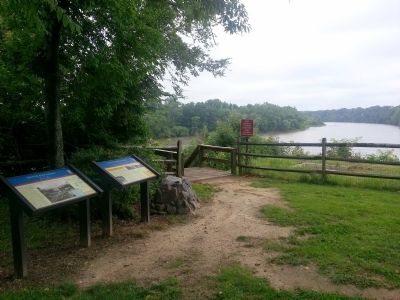
Photographed by Bernard Fisher, June 27, 2013
5. Dutch Gap Canal CWT Markers
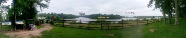
Photographed by Bernard Fisher, June 27, 2013
6. Dutch Gap Panorama
Credits. This page was last revised on April 29, 2024. It was originally submitted on June 27, 2013, by Bernard Fisher of Richmond, Virginia. This page has been viewed 1,186 times since then and 38 times this year. Last updated on January 9, 2021, by Bradley Owen of Morgantown, West Virginia. Photos: 1, 2, 3, 4, 5, 6. submitted on June 27, 2013, by Bernard Fisher of Richmond, Virginia.
