Bridgewater in Rockingham County, Virginia — The American South (Mid-Atlantic)
Bridgewater
Historic North River Crossing
| — | 1862 Valley Campaign | — |
Photographed by Robert H. Moore, II, February 20, 2009
1. Bridgewater Marker
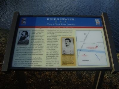
Jackson and part of his staff attended a religious service in the field across the river to your right front. The Rev. Maj. Robert Dabney, Jackson’s chief-of-staff, preached to Col. Zephaniah T. Conner’s brigade of Virginia and Georgia infantry from the text: “Come unto me, all that labor and are heavy laden, and I will give you rest.”
As the army began crossing the river, Jackson, his staff, Conner, and Capt. (later Gen.) Robert D. Lilley had a midday meal at the brick home of George Gibbon, .3 mile southwest on the left side of the turnpike.
On October 7, 1864, Gen. Fitzhugh Lee’s cavalry division (commanded by Gen. Thomas L. Rosser) crossed
this page online
Erected by Shenandoah Valley Battlefields Foundation & Virginia Civil War Trails.
Topics and series. This historical marker is listed in these topic lists: Bridges & Viaducts • War, US Civil. In addition, it is included in the Virginia Civil War Trails series list. A significant historical month for this entry is May 1741.
Location. 38° 22.793′ N, 78° 58.772′ W. Marker is in Bridgewater, Virginia, in Rockingham County. It can be reached from the intersection of South Main Street (State Highway 42) and West Riverside Drive, on the right when traveling south. Touch for map. Marker is at or near this postal address: 303 S Main St, Bridgewater VA 22812, United States of America. Touch for directions.

Regionally, this marker is in the Shenandoah Valley. It is also in the American South and specifically in the Upper South. Globally, it is in North America, the Western Hemisphere, the Western World, and the Anglosphere. Historically, it finds itself in what was once the territory of the Mississippian Culture, one of the original Thirteen Colonies, one of the
Photographed by Robert H. Moore, II, February 20, 2009
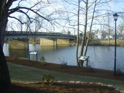
2. Bridgewater 's riverside Civil War Trails Markers (2)
Other nearby markers. At least 8 other markers are within walking distance of this marker: A different marker also named Bridgewater (here, next to this marker); In Honor and Remembrance (within shouting distance of this marker); The Roscoe Burgess Riverwalk (within shouting distance of this marker); The Litten Water Gardens at Edgebriar Park (within shouting distance of this marker); Dr. John G. Brown House (approx. 0.2 miles away); Bridgewater Historic District (approx. 0.2 miles away); Sipe Center (approx. ¼ mile away); The Alexander Mack Memorial Library (approx. half a mile away). Touch for a list and map of all markers in Bridgewater.
Another marker is no longer nearby. Bridgewater (was a few steps from this marker but has been replaced with another marker now near it).
More about this marker. In the upper left is a portrait of General Stonewall Jackson. In the center is a portrait of Colonel John D. Imboden. In 1863, the trustees of Warm Springs Turnpike asked Imboden if they could be reimbursed for the destroyed bridge. They never received compensation from either the Confederate or United States government. To the right is a map of the area.
Credits. This page was last revised on September 14, 2024. It was originally submitted on February 25, 2009, by Robert H. Moore, II of Winchester, Virginia. This page has been viewed 2,588 times since then and 63 times this year. Last updated on August 6, 2024, by Carl Gordon Moore Jr. of North East, Maryland. Photos: 1, 2. submitted on February 25, 2009, by Robert H. Moore, II of Winchester, Virginia. • Bernard Fisher was the editor who published this page.
