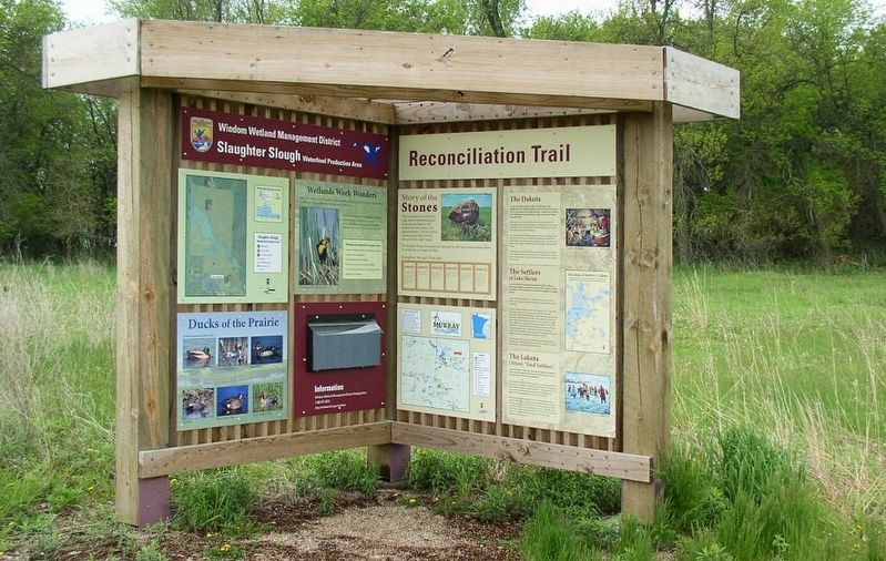
Reconciliation Trail
Story of the Stones
The monument rests on three large stones representing and honoring the Dakota, the Settlers and the Lakota. It is approximately 1,750 feet down a mown grass trail, behind you and to the right (west).
The Slaughter Slough monument was dedicated in 2003 and commemorates events occurring here on August 20, 1862.
Slaughter Slough Timeline
August 18, 1862: Beginning of the Dakota Conflict. Attacks on the Upper and Lower Sioux Agencies and other settlements, and ambush at the Redwood Ferry Crossing.
August 20, 1862: Attack on the Lake Shetek Settlement
November 11, 1862: Shetek captives are discovered by a trader, Charles "Major" Gaplin.
November 13, 1862: Fool Soldiers begin journey to rescue the captives.
November 15, 1862: Fool Soldiers meet the captives by present-day Mobridge, South Dakota.
July 1987: Descendents of some of the Dakota, white settlers and Lakota returned to this site to begin the process of reconciliation.
The Dakota
A stone beneath the monument represents the Dakota, early inhabitants of this land who exhibited so much restraint in reacting to the U.S. government and its broken promises. Angered and frustrated, a few Dakota took action, resulting in a tragic end for many Dakota and settlers alike.
Following
the 1851 treaties at Traverse des Sioux and Mendota, the United States pushed the Dakota Indians of Minnesota onto reservations along both the north and south sides of the Minnesota River, just east of the recently constructed Fort Ridgely.The treaties promised the Dakota annuities and cash in exchange for the land they were forced to give up, but the treaties were violated by the United States. Promised goods and cash didn't appear. And when crops failed in 1862, hunger was added to the list of hardships endured by the Dakota.
Following the conclusion of the Dakota war, the Dakota were virtually exiled from Minnesota onto reservations in the Dakota Territory. Some fled to Canada. Many Dakota did remain and others eventually returned to Minnesota.
The Settlers at Lake Shetek
A stone beneath the monument represents the settlers. Most were brave, hard working young families trying to make a living in a harsh environment. They became innocent bystanders caught up in a larger conflict.
A rush of white settlers arrived in the area after the construction of Fort Ridgely. Nine families, totaling fifty-four people, eventually settled around Lake Shetek.
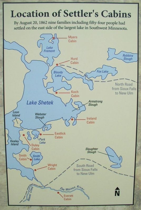
A group of Dakota attacked the settlement on August 20, 1862. Two settlers, John Voight, living at the Hurd cabin, and Andreas Koch were killed immediately. Thirty-four settlers gathered
at the Wright cabin, and negotiated with Pawn, a Dakota known to the settlers. With a guarantee of safety, they agreed to go back East and headed toward New Ulm, Minnesota in a single wagon. Within a few miles, the settlers encountered several Dakota, Pawn among them. The families fled down an incline into the tall grass of what is now called Slaughter Slough. A battle ensued in with some Dakota another settler being killed. Several more settlers were killed after leaving the slough, having been promised safety if they would come out.The remaining Dakota took eleven captives and were taken north and west. A woman and a child escaped, and an infant dies. The remaining two women and six children were held captive for three months.
The Lakota (Teton) "Fool Soldiers"
A stone beneath the monument represents the Lakota "Fool Soldiers". They rescued the captives never honored for their deed and were even shunned by much of the Lakota community.
In the middle of November 1862, a group of ten young men set out from Fort Pierre, South Dakota to a location north of what is now Mobridge, South Dakota to rescue the remaining captives. This group had formed to promote peace among Indian nations and between Indians and whites and was scornfully referred to as the "Fool Soldiers".
Upon finding the captives and their captors, they engaged in tense, extended
negotiations. Ultimately, they traded their horses, guns, and other personal effects for the release of the remaining captives. With one remaining horse, they transported these women and children back to Fort Pierre: A long, cold journey of over 100 miles. The "Fool Soldiers" received no compensation for this rescue, nor were they given recognition for this heroic act.
[Map:]
Location of Settler's Cabins
By August 20, 1862 nine families including fifty-four people had settled on the east side of the largest lake in Southwest Minnesota.
Erected by U.S. Fish & Wildlife Service.
Topics. This historical marker is listed in these topic lists: Native Americans • Peace • Settlements & Settlers • Wars, US Indian. A significant historical date for this entry is August 20, 1862.
Location. 44° 4.998′ N, 95° 36.798′ W. Marker is near Currie, Minnesota, in Murray County. Marker is on 225th Avenue, 0.4 miles north of 161st Street, on the left when traveling north. Marker is part of a kiosk on the edge of the parking lot for Slaughter Slough Waterfowl Production Area. Touch for map. Marker is in this post office area: Currie MN 56123, United States of America. Touch for directions.
Other nearby markers. At least 8 other markers are within 14 miles of this marker, measured as the crow flies. Slaughter Slough Waterfowl Production Area (approx. 0.3 miles away); Currie Veterans Memorial (approx. 2.7 miles away); Tragedy Surrounds Smith Lake on August 20, 1862 (approx. 4 miles away); Shetek Monument (approx. 4 miles away); Avoca (approx. 9˝ miles away); The Tracy Tornado Tree / Tracy Tornado Clock (approx. 10.8 miles away); Tracy Tornado Memorial (approx. 10.8 miles away); Old Soldier (approx. 13.3 miles away). Touch for a list and map of all markers in Currie.
Credits. This page was last revised on January 15, 2021. It was originally submitted on January 15, 2021, by McGhiever of Minneapolis, Minnesota. This page has been viewed 272 times since then and 44 times this year. Photos: 1, 2. submitted on January 15, 2021, by McGhiever of Minneapolis, Minnesota. • Devry Becker Jones was the editor who published this page.

