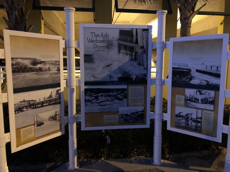
The Ash Wednesday Storm
March, 1962
— Along the Oceanfront —
![The Ash Wednesday Storm Marker [Center panel]. Click for full size. The Ash Wednesday Storm Marker [Center panel] image. Click for full size.](Photos5/564/Photo564417.jpg?120202140700PM)
Coastal areas along the Atlantic shoreline have always been acutely vulnerable to hurricanes and northeast storms. Virginia Beach is no exception. Ironically, the most massive and destructive storm of the modern era wasn't a hurricane or even a northeaster. It was a freak storm that was in early March, 1962 when two large storm systems came together and stalled off the Virginia Capes at the Virginia Beach coastline.
When the storm moved ashore in the early morning of March 7, 1962 (Ash Wednesday), the full force of the storm produced 20-foot to 30-foot waves that relentlessly pounded the Virginia Beach Oceanfront for three days.
Storms have partially or completely washed out the wooden Virginia Beach Fishing pier at 15th Street eight times since it was built in 1948.
Later that day, at the height of the storm, a maximum tidal elevation of 7.3 feet was recorded at high tide. The ocean had crashed through the concrete bulkhead and dune line farther north, dumping sand and flood water onto Atlantic Avenue.
Army DUKS had to be careful to avoid submerged cars and other underwater obstacles during the evacuation process. Notice that the traf[f]ic lights at 57th Street were still in working order.
Private Oceanfront homes that today would be valued in the millions of dollars were destroyed.
In
1962, there was no storm water drainage system in place, so seawater and sand were trapped along Atlantic Avenue. As ween in these photographs, North End beach residents had to be evacuated from their homes to higher ground by Army DUKS from Fort Story.Topics. This historical marker is listed in these topic lists: Disasters • Waterways & Vessels. A significant historical month for this entry is March 1962.
Location. 36° 51.851′ N, 75° 58.804′ W. Marker is in Virginia Beach, Virginia. It is in North Virginia Beach. Marker is on 36th Street just west of Atlantic Avenue, on the right when traveling west. Touch for map. Marker is at or near this postal address: 205 36th St, Virginia Beach VA 23451, United States of America. Touch for directions.
Other nearby markers. At least 8 other markers are within walking distance of this marker. Seaside Park Casino / The Cavalier Hotel (here, next to this marker); The Winds of Change (here, next to this marker); A Day at the Beach (here, next to this marker); VB Now (here, next to this marker); The Princess Anne Hotel (a few steps from this marker); Premier Boardwalk Events (a few steps from this marker); The Graveyard of the Atlantic (a few steps from this marker); The Threshold of a New Nation (a few steps from this marker). Touch for a list and map of all markers in Virginia Beach.
![The Ash Wednesday Storm Marker [Left panel]. Click for full size. The Ash Wednesday Storm Marker [Left panel] image. Click for full size.](Photos5/564/Photo564416.jpg?120202135700PM)
![The Ash Wednesday Storm Marker [Right panel]. Click for full size. The Ash Wednesday Storm Marker [Right panel] image. Click for full size.](Photos5/564/Photo564418.jpg?120202140900PM)
Credits. This page was last revised on February 1, 2023. It was originally submitted on January 20, 2021, by Devry Becker Jones of Washington, District of Columbia. This page has been viewed 519 times since then and 50 times this year. Photos: 1, 2, 3, 4. submitted on January 20, 2021, by Devry Becker Jones of Washington, District of Columbia.
Editor’s want-list for this marker. Clear, daylight photos of the marker and its context • Can you help?
