Locks of the Dismal Swamp Canal

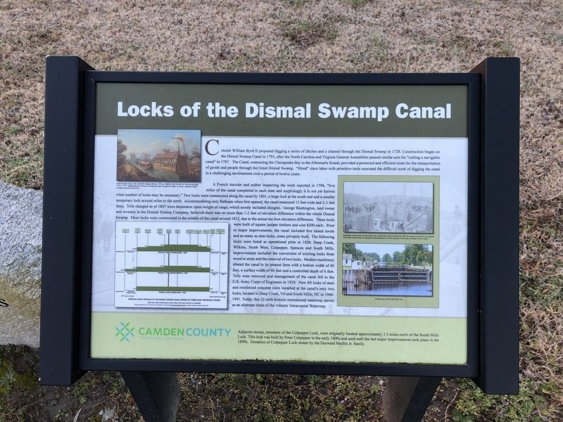
Colonel William Byrd II proposed digging a series of ditches and a channel through the Dismal Swamp in 1728. Construction began on the Dismal Swamp Canal in 1793, after the North Carolina and Virginia General Assemblies passed similar acts for "cutting a navigable canal in 1787. The Canal, connecting the Chesapeake Bay to the Albemarle Sound, provided a protected and efficient route for the transportation of goods and people through the Great Dismal Swamp. "Hired" slave labor with primitive tools executed the difficult work of digging the canal in a challenging environment over a period of twelve years.
A French traveler and author inspecting the work reported in 1796, "five miles of the canal completed in each state and surprisingly it is not yet known what number of locks may be necessary." Two locks were constructed along the canal by 1801, a large lock at the south end and a smaller temporary lock several miles to the north. Accommodating only flatboats when first opened, the canal measured 15 feet wide and 2-3 feet deep. Tolls charged as of 1807 were dependent upon weight of cargo, which mostly included shingles. George Washington, land owner and investor in the Dismal Swamp Company, believed there was no more than 1-2 feet of elevation difference within the whole Dismal Swamp. More locks were constructed in the middle
of the canal around 1812, due to the actual ten foot elevation difference. These locks were built of square juniper timbers and cost $300 each. Prior to major improvements, the canal included five raised levels and as many as nine locks, some privately built. The following locks were listed as operational prior to 1826: Deep Creek, Wilkins, North West, Culpepper, Spences and South Mills. Improvements included the conversion of existing locks from wood to stone and the removal of two locks. Modern machinery altered the canal to its present form with a bottom width of 40 feet, a surface width of 60 feet and a controlled depth of 6 feet. Tolls were removed and management of the canal fell to the U.S. Army Corps of Engineers in 1929. New lift locks of steel and reinforced concrete were installed at the canal's only two locks, located in Deep Creek, VA and South Mills, NC in 1940-1941. Today, this 22-mile historic recreational waterway serves as an alternate route of the Atlantic Intracoastal Waterway.
[Caption:]
Rebuilding of the Dismal Swamp Canal Lock at South Mills. Between 1896 and 1899, the masonry of the lock was replaced with timber and the canal was enlarged to the dimensions of 60 feet wide and 10 feet deep. (Courtesy of Alex Leary.)
Erected by Camden County, North Carolina

Topics and series. This historical marker is listed in these topic lists: Industry & Commerce • Waterways & Vessels. In addition, it is included in the Former U.S. Presidents: #01 George Washington series list. A significant historical year for this entry is 1728.
Location. 36° 19.744′ N, 76° 10.464′ W. Marker is in Camden, North Carolina, in Camden County. Marker is on State Highway 343, 0.1 miles north of Plank Bridge Road, on the right when traveling south. Touch for map. Marker is at or near this postal address: 117 N Carolina Hwy 343 S, Camden NC 27921, United States of America. Touch for directions.
Other nearby markers. At least 8 other markers are within 3 miles of this marker, measured as the crow flies. Camden County Jail (a few steps from this marker); Camden County Courthouse (within shouting distance of this marker); Veterans Memorial (within shouting distance of this marker); Isaac Gregory (approx. 0.2 miles away); Dempsey Burgess (approx. ¼ mile away); a different marker also named Isaac Gregory (approx. ¼ mile away); Lemuel Sawyer (approx. one mile away); Former Site of Sawyer's Creek / Marian Anderson High School (approx. 2.2 miles away). Touch for a list and map of all markers in Camden.
Credits. This page was last revised on January 20, 2021. It was originally submitted on January 20, 2021, by Devry Becker Jones of Washington, District of Columbia. This page has been viewed 760 times since then and 67 times this year. Photos: 1, 2. submitted on January 20, 2021, by Devry Becker Jones of Washington, District of Columbia.