Village of Deep Creek
"The den of the Rebels"
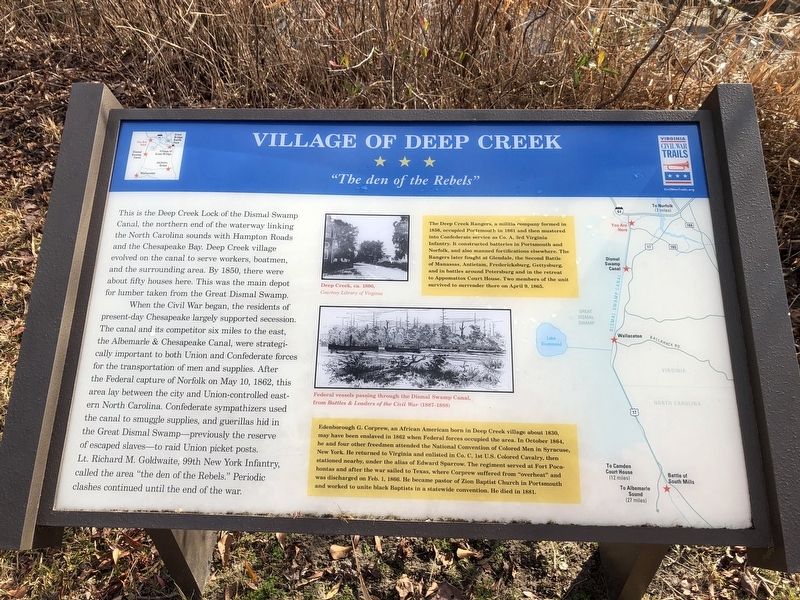
This is the Deep Creek Lock of the Dismal Swamp Canal, the northern end of the waterway linking the North Carolina sounds with Hampton Roads and the Chesapeake Bay. Deep Creek village evolved on the canal to serve workers, boatmen, and the surrounding area. By 1850, there were about fifty houses here. This was the main depot for lumber taken from the Great Dismal Swamp.
When the Civil War began, the residents of present-day Chesapeake largely supported secession. The canal and its competitor six miles to the east, the Albemarle & Chesapeake Canal, were strategically important to both Union and Confederate forces for the transportation of men and supplies. After the Federal capture of Norfolk on May 10, 1862, this area lay between the city and Union-controlled eastern North Carolina. Confederate sympathizers used the canal to smuggle supplies, and guerillas hid in the Great Dismal Swamp—previously the reserve of escaped slaves—to raid Union picket posts. Lt. Richard M. Goldwaite, 99th New York Infantry, called the area "the den of the Rebels." Periodic clashes continued until the end of the war.
[Sidebars:]
The Deep Creek Rangers, a militia company formed in 1856, occupied Portsmouth in 1861 and then mustered into Confederate service as Co. A, 3rd Virginia Infantry. It constructed batteries
in Portsmouth and Norfolk, and also manned fortifications elsewhere. The Rangers later fought at Glendale, the Second Battle of Manassas, Antietam, Fredericksburg, Gettysburg, and in battles around Petersburg and in the retreat to Appomattox Court House. Two members of the unit survived to surrender there on April 9, 1865.
Edenborough G. Corprew, an African American born in Deep Creek village about 1830, may have been enslaved in 1862 when Federal forces occupied the area. In October 1864, he and four other freedmen attended the National Convention of Colored Men in Syracuse New York. He returned to Virginia and enlisted in Co. C, 1st U.S. Colored Cavalry, then stationed nearby, under the alias of Edward Sparrow. The regiment served at Fort Pocahontas and after the war sailed to Texas, where Corprew suffered from "overheat" and was discharged on Feb. 1, 1866. He became pastor of Zion Baptist Church in Portsmouth and worked to unite black Baptists in a statewide convention. He died in 1881.
Erected by Virginia Civil War Trails.
Topics and series. This historical marker is listed in these topic lists: African Americans • Churches & Religion • War, US Civil • Waterways & Vessels. In addition, it is included in the Virginia Civil War Trails series list. A significant historical date for this entry is April 9, 1865.
Location.
Other nearby markers. At least 8 other markers are within 5 miles of this marker, measured as the crow flies. Justin Holland (approx. 0.4 miles away); Owens-Melvin House (approx. 0.8 miles away); Cody S. Childers (approx. 2˝ miles away); Great Dismal Swamp National Wildlife Refuge (approx. 4.2 miles away); Site of the Nansemond Indian Public School #9 (approx. 4.2 miles away); Unknown and Known Afro-Union Civil War Soldiers Memorial (approx. 4.3 miles away); Dismal Swamp Canal Trail (approx. 4.4 miles away); Sunray (approx. 4.6 miles away). Touch for a list and map of all markers in Chesapeake.
Related marker. Click here for another marker that is related to this marker. This marker has replaced the linked marker.
Credits. This page was last revised on February 1, 2023. It was originally submitted on January 21, 2021, by Devry Becker Jones of Washington, District of Columbia. This page has been viewed 783 times since then and 198 times this year. Photos: 1, 2. submitted on January 21, 2021, by Devry Becker Jones of Washington, District of Columbia.

