Near Worden in Yellowstone County, Montana — The American West (Mountains)
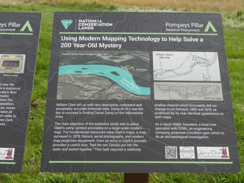
Using Modern Mapping Technology to Help Solve a 200 Year-Old Mystery

Photographed By Barry Swackhamer, September 14, 2020
1. Using Modern Mapping Technology to Help Solve a 200 Year-Old Mystery Marker
Captions: (upper left) Current photo from Google Earth, Approximate 1806 river channel; (Upper right, top & bottom) William Clark's 1806, Clark's campsite symbol; 1878 GLO Map.
The main objective of the extensive study was to place Clark's camp symbol accurately on a large-scale modern map. The fundamental resources were Clark's maps, a map surveyed in 1878, historic aerial photographs, and modern map projection equipment. Even an entry in Clark's journals provided a useful clue, "had the two Canoes put into the water and lashed together." That task required a relatively shallow channel which fortunately did not change much between 1806 and 1878, as evidenced by its nearly identical appearance on both maps.
As a result, Ralph Saunders, a local river specialist with DOWL, an engineering company, proposed a location upon which to do an archaeological investigation.
Erected by Bureau of Land Management and National Conservation Lands.
Topics and series. This historical marker is listed in these topic lists: Exploration • Waterways & Vessels. In addition, it is included in the Lewis & Clark Expedition series list.
Location. 45° 59.692′ N, 108° 0.165′ W. Marker is near Worden, Montana, in Yellowstone County. Marker can be reached from U.S. 312 near South 31st Road, on the right when traveling west. This marker is on The "Yellowstone River" Walkway at Pompeys Pillar National Monument. Touch for map. Marker is at or near this postal address: 3001 Highway 312, Worden MT 59088, United States of America. Touch for directions.
Other nearby markers. At least 8 other markers are within walking distance of this marker. Clark's Canoe Camp on the Yellowstone, Archaeology Study (here, next to this marker); Injury Forces a Halt to Build Canoes (here, next to this marker); Preparations of Continuing the Trip (here, next to this marker); Making Canoes, Then and Now (a few steps from this marker); Sign of American Indians (a few steps from this marker); Transportation: Hoofing It (within shouting distance of this marker); Transportation: Traveling Downstream (within shouting distance of this marker); Three Forks: Clark's Party Splits (within shouting distance of this marker). Touch for a list and map of all markers in Worden.
Credits. This page was last revised on January 27, 2021. It was originally submitted on January 27, 2021, by Barry Swackhamer of Brentwood, California. This page has been viewed 200 times since then and 24 times this year. Photos: 1, 2. submitted on January 27, 2021, by Barry Swackhamer of Brentwood, California.
