Montclaire South in Charlotte in Mecklenburg County, North Carolina — The American South (South Atlantic)
General Paul R. Younts Expressway
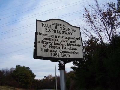
Photographed by Stanley and Terrie Howard, October 16, 2008
1. General Paul R. Younts Expressway Marker
Topics. This historical marker is listed in these topic lists: Industry & Commerce • Roads & Vehicles.
Location. 35° 7.292′ N, 80° 55.084′ W. Marker is in Charlotte, North Carolina, in Mecklenburg County. It is in Montclaire South. It is on Interstate 77 near Interstate 485. Touch for map. Marker is in this post office area: Charlotte NC 28273, United States of America. Touch for directions.

Regionally, this marker is in North Carolina’s Piedmont. It is also in the American South and specifically in the Upper South. Globally, it is in North America, the Western Hemisphere, the Western World, and the Anglosphere. Historically, it finds itself in what was once the territory of the Mississippian Culture, one of the original Thirteen Colonies, one of the Confederate States of America, and the Antebellum South.
Other nearby markers. At least 8 other markers are within 4 miles of this marker, measured as the crow flies: Catawba Indian Reservation
this page online
Credits. This page was last revised on February 3, 2023. It was originally submitted on March 6, 2009, by Stanley and Terrie Howard of Greer, South Carolina. This page has been viewed 3,408 times since then and 91 times this year. Photo 1. submitted on March 6, 2009, by Stanley and Terrie Howard of Greer, South Carolina. • Bill Pfingsten was the editor who published this page.
