Point of Rocks in Frederick County, Maryland — The American Northeast (Mid-Atlantic)
Point of Rocks
The C&O Canal
— Canal Towns • Point of Rocks —
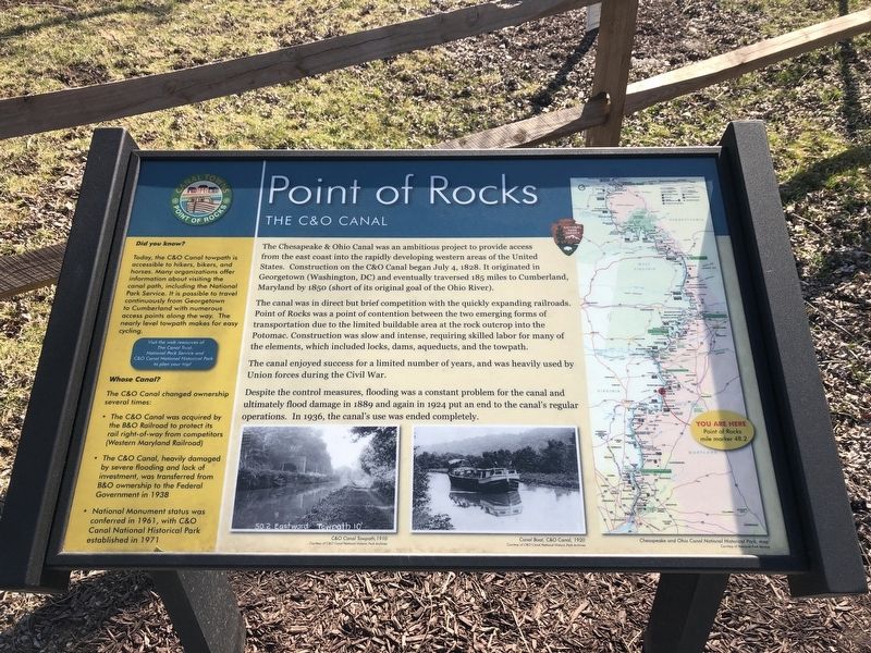
The Chesapeake & Ohio Canal was an ambitious project to provide access from the east coast into the rapidly developing western areas of the United States. Construction on the C&O Canal began July 4, 1828. It originated in Georgetown (Washington, DC) and eventually traversed 185 miles to Cumberland, Maryland by 1850 (short of its original coal of the Ohio River).
The canal was in direct but brief competition with the quickly expanding railroads. Point of Rocks was a point of contention between the two emerging forms of transportation due to the limited buildable area at the rock outcrop into the Potomac. Construction was slow and intense, requiring skilled labor for many of the elements, which included locks, dams, aqueducts, and the towpath.
The canal enjoyed success for a limited number of years, and was heavily used by Union forces during the Civil War.
Despite the control measures, flooding was a constant problem for the canal and ultimately flood damage in 1889 and again in 1924 put an end to the canal's regular operations. In 1936, the canal's use was ended completely.
[Sidebar:]
Did you know?
Today, the C&O Canal towpath is accessible to hikers, bikers, and horses. Many organizations offer information about visiting the canal path, including the National Park Service. It is possible to travel continuously from Georgetown to Cumberland with numerous access points along the way. The nearly level towpath makes for easy cycling.
Whose Canal?
The C&O Canal changed ownership several times:
• The C&O Canal was acquired by the B&O Railroad to protect its rail right-of-way from competitors (Western Maryland Railroad)
• The C&O Canal, heavily damaged by severe flooding and lack of investment, was transferred from B&O ownership to the Federal Government in 1938
• National Monument status was conferred in 1961, with C&O Canal National Historical Park established in 1971
Topics and series. This historical marker is listed in these topic lists: Industry & Commerce • Railroads & Streetcars • War, US Civil • Waterways & Vessels. In addition, it is included in the Baltimore and Ohio Railroad (B&O), and the Chesapeake and Ohio (C&O) Canal series lists. A significant historical date for this entry is July 4, 1828.
Location. 39° 16.454′ N, 77° 32.37′ W. Marker is in Point of Rocks, Maryland, in Frederick County. Marker is on Clay Street (Maryland Route 28) east of Monroe Street, on the right when traveling east. Touch for map. Marker is at or near this postal address: 3721 Clay St, Point of Rocks MD 21777, United States of America. Touch for directions.
Other nearby markers. At least 8 other markers
Credits. This page was last revised on October 12, 2021. It was originally submitted on March 6, 2021, by Devry Becker Jones of Washington, District of Columbia. This page has been viewed 345 times since then and 18 times this year. Photos: 1, 2. submitted on March 6, 2021, by Devry Becker Jones of Washington, District of Columbia.

