Leesburg in Loudoun County, Virginia — The American South (Mid-Atlantic)
Aftermath of Ballís Bluff
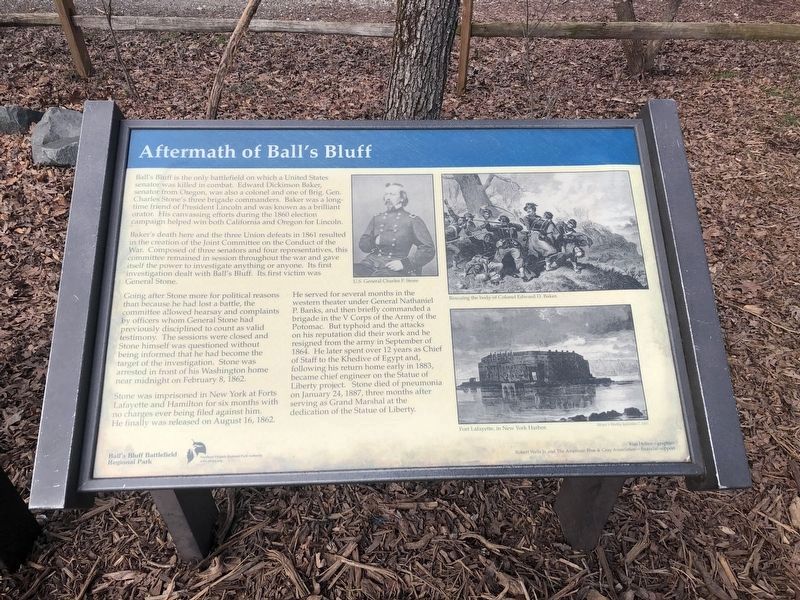
Ballís Bluff is the only battlefield on which a United States senator was killed in combat. Edward Dickinson Baker, senator from Oregon, was also a colonel and one of Brig. Gen. Charles Stoneís three brigade commanders. Baker was a long-time friend of President Lincoln and was known as a brilliant orator. His canvassing efforts during the 1860 election campaign helped win both California and Oregon for Lincoln.
Bakerís death here and three Union defeats in 1861 resulted in the creation of the Joint Committee on the Conduct of the War. Composed of three senators and four representatives, this committee remained in session throughout the war and gave itself the power to investigate anything or anyone. Its first investigation dealt with Ballís Bluff. Its first victim was General Stone.
Going after Stone more for political reasons than because he had lost a battle, the committee allowed hearsay and complaints by officers whom General Stone had previously disciplined to count as valid testimony. The sessions were closed and Stone himself was questioned without being informed he had become the target of the investigation. Stone was arrested in front of his Washington home near midnight on February 8, 1862.
Stone was imprisoned in New York at Forts Lafayette and Hamilton for six months with no charges ever being filed against him. He finally was released on August 16, 1862.
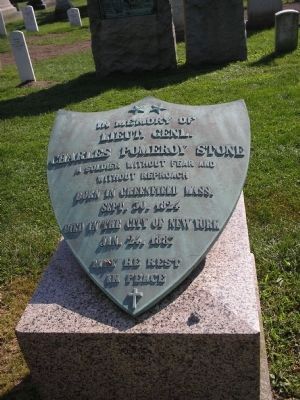
He served for several months in the western theater under General Nathaniel P. Banks, and then briefly commanded a brigade in the V Corps of the Army of the Potomac. But typhoid and the attacks on his reputation did their work and he resigned from the army in September of 1864. He later spent over 12 years as Chief of Staff to the Khedive of Egypt and, following his return home early in 1883, became chief engineer on the Statue of Liberty project. Stone died of pneumonia on January 24, 1887, three months after serving as Grand Marshall at the dedication of the Statue of Liberty.
Erected by Ball's Bluff Regional Park/Northern Virginia Regional Park Authority.
Topics and series. This historical marker is listed in this topic list: War, US Civil. In addition, it is included in the Former U.S. Presidents: #16 Abraham Lincoln, and the NOVA Parks series lists. A significant historical month for this entry is January 1863.
Location. 39° 7.825′ N, 77° 31.846′ W. Marker is in Leesburg, Virginia, in Loudoun County. Marker can be reached from Ballís Bluff Road, on the right when traveling east. Located inside Ballís Bluff Regional Park, just off the parking lot. Touch for map. Marker is in this post office area: Leesburg VA 20176, United States of America. Touch for directions.
Other nearby markers. At least 8 other markers are within walking distance of this marker. The Battle of Ball's Bluff in Perspective (here, next to this marker); A Divided America, A Divided Loudoun County (here, next to this marker); Battle of Balls Bluff (here, next to this marker); Additional Area Civil War Sites (here, next to this marker); The Battle at Ballís Bluff (within shouting distance of this marker); Battle of Ball's Bluff - October 21, 1861 (about 300 feet away, measured in a direct line); a different marker also named The Battle of Ball's Bluff (about 300 feet away); 8th Virginia Volunteer Infantry Regiment (about 500 feet away). Touch for a list and map of all markers in Leesburg.
More about this marker. The marker displays a portrait of General Charles P. Stone. A paintďRecovering the body of Colonel Edward D. Baker.Ē A drawing on the lower right shows Fort Lafayette, New York.
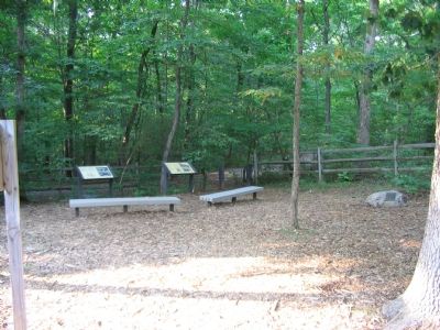
Regarding Aftermath of Ballís Bluff. This marker is one of a set along the Balls Bluff Battlefield walking trail. See the Balls Bluff Virtual Tour by Markers link below for details on each stop.
Related marker. Click here for another marker that is related to this marker. This marker has replaced the linked marker.
Also see . . .
1. Battle of Ball's Bluff.
Wikipedia entry (Submitted on April 29, 2024, by Larry Gertner of New York, New York.)
2. Balls Bluff Battlefield Virtual Tour by Marker. Over twenty markers detail the action at Balls Bluff and related sites. Please use the Click to map all markers shown on this page option at the bottom of the page to view a map of the marker locations. The hybrid view offers an excellent overlook of the park. (Submitted on November 11, 2007, by Craig Swain of Leesburg, Virginia.)
Credits. This page was last revised on April 29, 2024. It was originally submitted on August 29, 2007, by Craig Swain of Leesburg, Virginia. This page has been viewed 1,805 times since then and 30 times this year. Last updated on March 6, 2021, by Bradley Owen of Morgantown, West Virginia. Photos: 1. submitted on March 6, 2021, by Devry Becker Jones of Washington, District of Columbia. 2. submitted on August 29, 2007, by Craig Swain of Leesburg, Virginia. 3. submitted on September 7, 2009, by Bill Coughlin of Woodland Park, New Jersey. • J. Makali Bruton was the editor who published this page.


