The Blue Ridge Railroad
The Blue Ridge Tunnel
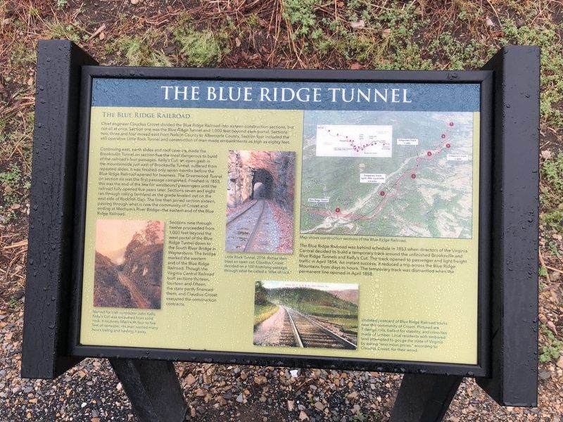
Chief engineer Claudius Crozet divided the Blue Ridge Railroad into sixteen construction sections, but not all at once. Section one was the Blue Ridge Tunnel and 1,000 feet beyond each portal. Sections two, three and four moved east from Nelson County to Albemarle County. Section four included the still operative Little Rock Tunnel and construction of man-made embankments as high as eighty feet.
Continuing east, earth slides and roof cave-ins made the Brooksville Tunnel on section five and the most dangerous to build of the railroad's four passages. Kelly's Cut, an open gash in the mountainside just east of Brooksville Tunnel, suffered from repeated slides. It was finished only seven months before the Blue Ridge Railroad opened for business. The Greenwood Tunnel on section six was the first passage completed. Finished in 1853, this was the end of the line for westbound passengers until the railroad fully opened five years later. Sections seven and eight ran through rolling farmland as the grade leveled out the east side of Rockfish Gap. The line then joined section sixteen, passing through what is now the community of Crozet and ending at Mechum's River Bridge—the eastern end of the Blue Ridge Railroad.
Sections nine through twelve proceeded from 1,000 feet beyond the west portal of the Blue Ridge Tunnel down to
the South River Bridge in Waynesboro. The bridge marked the western end of the Blue Ridge Railroad. Though the Virginia Central Railroad built sections thirteen, fourteen and fifteen, the state partly financed them, and Claudius Crozet executed the construction contracts.The Blue Ridge Railroad was behind schedule in 1853 when directors of the Virginia Central decided to build a temporary track around the unfinished Brooksville and Blue Ridge Tunnels and Kelly's Cut. The track opened to passenger and light freight traffic in April 1854. An instant success, it reduced a trip across the Blue Ridge Mountains from days to hours. The temporary track was dismantled when the permanent line opened in April 1858.
[Captions:]
Named for Irish contractor John Kelly, Kelly's Cut was excavated from solid rock, it routinely filled with four to five feet of rainwater. His men wasted many hours baling and hauling it away.
Little Rock Tunnel, 2016. Rather than blast an open cut, Claudius Crozet decided on a 100-foot-long passage through what he called a "dike of rock."
Undated postcard of Blue Ridge Railroad tracks near the community of Crozet. Pictured are T-design rails, ballast for stability, and cross ties made of lumber. Local residents with timbered land attempted to gauge the state of Virginia by asking "enormous prices," according to Claudius
Erected 2020 by Nelson County Parks & Recreation.
Topics. This historical marker is listed in these topic lists: Bridges & Viaducts • Natural Features • Natural Resources • Railroads & Streetcars. A significant historical month for this entry is April 1854.
Location. 38° 1.888′ N, 78° 50.883′ W. Marker is in Afton, Virginia, in Nelson County. Marker is on Blue Ridge Tunnel Trail, 0.4 miles west of Afton Depot Lane, on the right when traveling west. Touch for map. Marker is at or near this postal address: 435 Blue Ridge Tunnel Trail, Afton VA 22920, United States of America. Touch for directions.
Other nearby markers. At least 8 other markers are within walking distance of this marker. The Laborers (about 600 feet away, measured in a direct line); Claudius Crozet (about 700 feet away); Greenwood-Afton Rural Historic District (approx. ¼ mile away); Flight of Richard C. duPont (approx. ¼ mile away); Rockfish Gap Meeting (approx. ¼ mile away); Virginia's Nineteenth-Century Transportation Challenges (approx. ¼ mile away); Crozet Blue Ridge Tunnel (approx. ¼ mile away); East Trailhead (approx. 0.3 miles away). Touch for a list and map of all markers in Afton.
Credits. This page was last revised on April 11, 2021. It was originally submitted on April 11, 2021, by Devry Becker Jones of Washington, District of Columbia. This page has been viewed 217 times since then and 22 times this year. Photos: 1, 2. submitted on April 11, 2021, by Devry Becker Jones of Washington, District of Columbia.

