Resaca in Gordon County, Georgia — The American South (South Atlantic)
Resaca — A Defensible Position
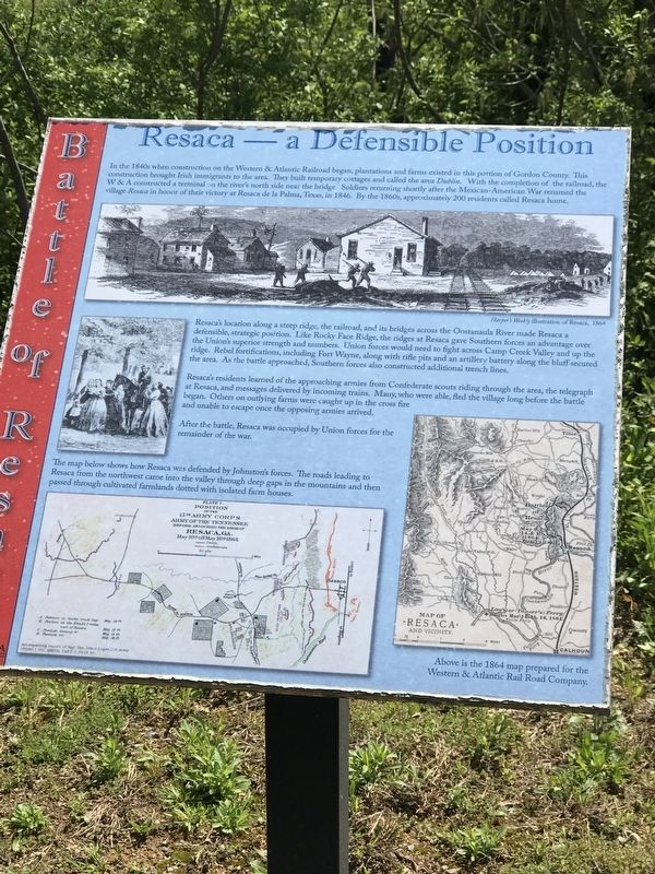
Resaca's location along a steep ridge, the railroad, and its bridges across the Oostanaula River made Resaca a defensible, strategic position. Like Rocky Face Ridge, the ridges at Resaca gave Southern forces an advantage over the Union's superior strength and numbers. Union forces would need to fight across Camp Creek Valley and up the ridge. Rebel fortifications, including Fort Wayne, along with rifle pits and an artillery battery along the bluff secured the area. As the battle approached, Southern forces also constructed additional trench lines.
Resaca's residents learned of the approaching armies from Confederate scouts riding through the area, the telegraph at Resaca, and messages delivered by incoming trains. Many, who were able, fled the village long before the battle began. Others on outlying farms were caught up in the cross fire and unable to escape once the opposing armies arrived.
After the battle, Resaca was occupied by Union forces for the remainder of the war.
Captions:
Top: Harper's Weekly illustration of Resaca, 1864
Bottom left: The map below shows how Resaca was defended by Johnston's forces. The roads leading to Resaca from the northwest came into the valley through deep gaps in the mountains and then passed through cultivated farmlands dotted with isolated farm houses.
Bottom right: Above is the 1864 map prepared for the Western & Atlantic Rail Road Company.
Erected by Georgia Department of Natural Resources - State Parks and Historic Sites.
Topics. This historical marker is listed in these topic lists: Railroads & Streetcars • Settlements & Settlers • War, US Civil. A significant historical date for this entry is May 9, 1846.
Location. 34° 34.641′ N, 84° 57.156′ W. Marker is in Resaca, Georgia, in Gordon County. Marker can be reached from Resaca Lafayette Road Northwest (Georgia Route 136). Marker is on the entrance road to Resaca Battlefield State Historic Site. Touch for map. Marker is at or near this postal address: 6 GA-136, Resaca GA 30735, United States of America. Touch for directions.
Other nearby markers. At least 8 other markers are within walking distance
of this marker. Crossing the Oostanaula at Lay's Ferry (here, next to this marker); The Road to Resaca (here, next to this marker); Battle of Resaca (a few steps from this marker); Logan's XV Corps to the South (approx. ¼ mile away); Dancers in the Red Clay Minuet (approx. 0.3 miles away); South Toward Atlanta (approx. 0.3 miles away); a different marker also named Battle of Resaca (approx. 0.6 miles away); a different marker also named Battle of Resaca (approx. 0.6 miles away). Touch for a list and map of all markers in Resaca.
Credits. This page was last revised on April 14, 2021. It was originally submitted on April 13, 2021, by Duane and Tracy Marsteller of Murfreesboro, Tennessee. This page has been viewed 210 times since then and 41 times this year. Photos: 1, 2. submitted on April 13, 2021, by Duane and Tracy Marsteller of Murfreesboro, Tennessee.

