El Oro de Hidalgo, Mexico State, Mexico — The Central Highlands (North America)
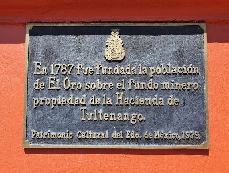
Hacienda de Tultenango
Patrimonio Cultural del Edo. de México, 1979.
In 1787 the town of El Oro was founded over the rustic mining area owned by the Hacienda de Tultenango.
Cultural Heritage of the State of Mexico, 1979.
Erected 1979 by Patrimonio Cultural del Estado de México.
Topics. This historical marker is listed in these topic lists: Colonial Era • Industry & Commerce • Settlements & Settlers. A significant historical year for this entry is 1787.
Location. 19° 48.12′ N, 100° 7.838′ W. Marker is in El Oro de Hidalgo, Estado de Mexico (Mexico State). Marker is on Constitución just north of Galeana, on the left when traveling north. Touch for map. Marker is in this post office area: El Oro de Hidalgo MEX 50600, Mexico. Touch for directions.
Other nearby markers. At least 8 other markers are within walking distance of this marker. The Mexican Golden Mile (here, next to this marker); El Oro de Hidalgo (here, next to this marker); The Founding of El Oro de Hidalgo (a few steps from this marker); Manuel Somera y Piña (a few steps from this marker); El Real del Oro (a few steps from this marker); Chamber of Commerce (within shouting distance of this marker); Hidalgo and Rayón in El Oro (within shouting distance of this marker); "Sor Juana Inés de la Cruz" Primary School (within shouting distance of this marker). Touch for a list and map of all markers in El Oro de Hidalgo.
Regarding Hacienda de Tultenango. A "hacienda" was a large landholding, usually under the control of one person or family and normally managed to produce agricultural products. The practice dates from the colonial period in Mexico.
Credits. This page was last revised on May 20, 2021. It was originally submitted on May 20, 2021, by J. Makali Bruton of Accra, Ghana. This page has been viewed 125 times since then and 14 times this year. Photos: 1, 2. submitted on May 20, 2021, by J. Makali Bruton of Accra, Ghana.

